File:Touristical map of the Allgäu.gif
Jump to navigation
Jump to search

Size of this preview: 600 × 600 pixels. Other resolutions: 240 × 240 pixels | 480 × 480 pixels | 768 × 768 pixels | 1,278 × 1,278 pixels.
Original file (1,278 × 1,278 pixels, file size: 409 KB, MIME type: image/gif)
Captions
Captions
Add a one-line explanation of what this file represents
Summary[edit]
| Description |
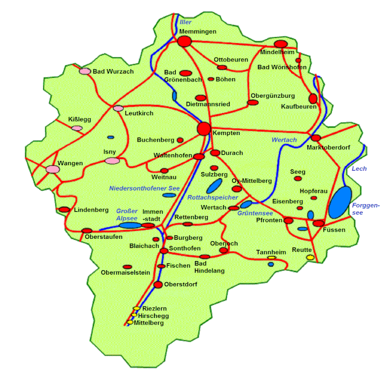
Deutsch: Skizze des Allgäus. ROT: Orte in Bayern, GELB: Orte in Österreich, PINK: Orte in Baden-Württemberg.
Dieses Bild wurde mit einer Grafiksoftware erstellt. Lizenz: GNU-FDL.
English: Map of the Allgäu. RED: Cities in Bavaria, YELLOW: Cities in Austria, PINK: Cities in Baden-Württemberg |
| Date | 30 March 2004 (original upload date) |
| Source | Transferred from de.wikipedia to Commons. |
| Author | Alexander.stohr (original file), new version: Kontrollstellekundl |
Licensing[edit]
Alexander.stohr, the copyright holder of this work, hereby publishes it under the following license:

|
Permission is granted to copy, distribute and/or modify this document under the terms of the GNU Free Documentation License, Version 1.2 or any later version published by the Free Software Foundation; with no Invariant Sections, no Front-Cover Texts, and no Back-Cover Texts. A copy of the license is included in the section entitled GNU Free Documentation License. |
| This file is licensed under the Creative Commons Attribution-Share Alike 3.0 Unported license. | ||
| Attribution: Alexander.stohr | ||
| ||
| This licensing tag was added to this file as part of the GFDL licensing update. |
Original upload log[edit]
The original description page was here. All following user names refer to de.wikipedia.
- 2008-05-19 07:38 Sir Boris 576×576× (54172 bytes) {{Information |Beschreibung = Skizze des Allgäus. Dieses Bild ist mit einer Grafiksoftware selbst erstellt worden. Lizenz: GNU-FDL. Entfernung eines nicht existenten (bzw. falsch eingezeichneten) Flusses durch [[Benutzer:Sir Boris|Sir Boris]] |Quelle = [
- 2004-03-30 21:47 Alexander.stohr 576×576× (55389 bytes) Skizze des Allgäus. Dieses Bild ist mit einer Grafiksoftware selbst erstellt worden. Lizenz: GNU-FDL.
| Annotations | This image is annotated: View the annotations at Commons |
File history
Click on a date/time to view the file as it appeared at that time.
| Date/Time | Thumbnail | Dimensions | User | Comment | |
|---|---|---|---|---|---|
| current | 13:24, 18 April 2015 | | 1,278 × 1,278 (409 KB) | Kontrollstellekundl (talk | contribs) | bessere Auflösung, neue Beschriftung, österr. + badenwürtt. Orten umgefärbt better resolution, renaming, new colours for cities in Austria (yellow) and Baden-Württemberg (pink) |
| 21:46, 25 March 2012 |  | 576 × 576 (53 KB) | OgreBot (talk | contribs) | (BOT): Reverting to most recent version before archival | |
| 21:46, 25 March 2012 |  | 576 × 576 (54 KB) | OgreBot (talk | contribs) | (BOT): Uploading old version of file from de.wikipedia; originally uploaded on 2004-03-30 21:47:26 by Alexander.stohr | |
| 21:45, 25 March 2012 |  | 576 × 576 (53 KB) | File Upload Bot (Magnus Manske) (talk | contribs) | Transfered from de.wikipedia by User:JuTa using CommonsHelper |
You cannot overwrite this file.
File usage on Commons
The following 2 pages use this file:
- Allgäu
- File:Allgaeu-outlined-w050-h050.gif (file redirect)
File usage on other wikis
The following other wikis use this file:
- Usage on de.wikipedia.org
- Usage on sl.wikipedia.org