File:Turgot map of Paris, sheet 18-19 - Norman B. Leventhal Map Center.jpg
קפיצה לניווט
קפיצה לחיפוש

גודל התצוגה המקדימה הזאת: 800 × 261 פיקסלים. רזולוציות אחרות: 320 × 104 פיקסלים | 640 × 209 פיקסלים | 1,024 × 334 פיקסלים | 1,280 × 418 פיקסלים | 2,560 × 835 פיקסלים | 17,930 × 5,850 פיקסלים.
לקובץ המקורי (17,930 × 5,850 פיקסלים, גודל הקובץ: 74.54 מ"ב, סוג MIME: image/jpeg)
כיתובים
כיתובים
נא להוסיף משפט שמסביר מה הקובץ מייצג
תקציר
[עריכה]| Warning | The original file is very high-resolution. It might not load properly or could cause your browser to freeze when opened at full size. |
|---|
| כותר | |||||||||||||||||||||||||||||||||||||||
| תיאור |
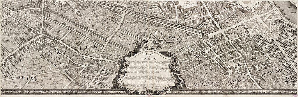
English: In marked contrast to the small, single-page city views appearing in late 16th and 17th century town atlases, were large, multi-sheet wall maps and birds eye views published during the 18th century. These richly detailed urban images depicted Europes largest and most important cities, such as London, Dublin, Rome, Vienna, and Paris. Displayed here is one page from a 20-sheet view of Paris, drawn from a birds eye perspective. Commissioned in 1734 by Michel Etienne Turgot, Prevot des Marchands (chief merchant or as we might say today, head of the chamber of commerce), this view was prepared by Louis Bretez, a sculptor, painter, and specialist in perspective. It took him five years to complete and publish this large-scale drawing of Frances capital city. Bretez constructed the drawing as if the city was being viewed from the northwest, looking southeast, with the Seine River running through the middle of his composition. He also places Éle de la Cité and Éle St. Louis, the historic heart of the city, near the center of the image. The twenty sheets are placed together create a dramatic wall map measuring approximately eight by ten feet. Such a presentation, as depicted in the composite reproduction displayed on the wall, captures the grandeur of the imperial city under the reign of Louis XV. Meanwhile, the exquisite detail which Bretez used to render individual buildings is evident in the atlas plate displayed below. |
||||||||||||||||||||||||||||||||||||||
| תאריך יצירה | |||||||||||||||||||||||||||||||||||||||
| מקור | Norman B. Leventhal Map Center | ||||||||||||||||||||||||||||||||||||||
| יוצר |
cartographer :
engraver :
|
||||||||||||||||||||||||||||||||||||||
| Geotemporal data | |||||||||||||||||||||||||||||||||||||||
| Map location | Paris | ||||||||||||||||||||||||||||||||||||||
| קנה מידה | Scale approximately 1:1,800 | ||||||||||||||||||||||||||||||||||||||
| Georeferencing | If inappropriate please set warp_status = skip to hide. | ||||||||||||||||||||||||||||||||||||||
| Bibliographic data | |||||||||||||||||||||||||||||||||||||||
| Map sheet | 18-19 | ||||||||||||||||||||||||||||||||||||||
| שפה | French | ||||||||||||||||||||||||||||||||||||||
| Archival data | |||||||||||||||||||||||||||||||||||||||
| אוסף |
|
||||||||||||||||||||||||||||||||||||||
| מספר גישה |
|
||||||||||||||||||||||||||||||||||||||
| ממדים | on sheet 63 x 90 cm | ||||||||||||||||||||||||||||||||||||||
| טכניקה | 1 map | ||||||||||||||||||||||||||||||||||||||
| כיתובים | dessiné et gravé sous les ordres de Messire Michel Etienne Turgot ... [et al.] ; levé et dessiné par Louis Bretez ; gravé par Claude Lucas ; et écrit par Aubin | ||||||||||||||||||||||||||||||||||||||

|
רישיון
[עריכה]
|
יצירה זו נמצאת בנחלת הכלל במדינת המקור ובמדינות אחרות בהם תקופת זכויות היוצרים היא משך חיי היוצר ו-100 שנה (או פחות) מפטירתו.
| |
| הקובץ הזה זוהה כקובץ חופשי מכל מגבלה ידועה תחת חוק זכויות היוצרים, כולל כל הזכויות הקשורות והסמוכות. | |
| Annotations | This image is annotated: View the annotations at Commons |
היסטוריית הקובץ
ניתן ללחוץ על תאריך/שעה כדי לראות את הקובץ כפי שנראה באותו זמן.
| תאריך/שעה | תמונה ממוזערת | ממדים | משתמש | הערה | |
|---|---|---|---|---|---|
| נוכחית | 11:22, 15 בפברואר 2018 | 5,850 × 17,930 (74.54 מ"ב) | Paris 16 (שיחה | תרומות) | ||
| 19:24, 13 בפברואר 2018 | 5,850 × 17,930 (73.76 מ"ב) | Paris 16 (שיחה | תרומות) | |||
| 10:00, 16 בנובמבר 2013 | 7,125 × 18,907 (63.5 מ"ב) | Paris 16 (שיחה | תרומות) |
אין באפשרותך לדרוס את הקובץ הזה.
שימוש בקובץ
הדפים הבאים משתמשים בקובץ הזה:
- Turgot map of Paris
- User:Paris 16/Recent uploads/2018 February 14-16
- Commons:Featured picture candidates/Log/February 2018
- Commons:Featured picture candidates/removal/Set/Turgot map of Paris, Kyoto University Library
- Commons:Featured pictures/Non-photographic media/Maps
- Commons:Featured pictures/Sets
- File:Turgot Map of Paris - Norman B. Leventhal Map Center.jpg (הפניה של קובץ)
שימוש גלובלי בקובץ
אתרי הוויקי השונים הבאים משתמשים בקובץ זה:
- שימוש באתר af.wikipedia.org
- שימוש באתר de.wikipedia.org
- שימוש באתר en.wikipedia.org
- Wikipedia:WikiProject France
- Wikipedia:Featured pictures/Diagrams, drawings, and maps/Maps
- Norman B. Leventhal Map Center
- Wikipedia:WikiProject France/Article Status
- Wikipedia:WikiProject France/Featured and good content
- Turgot map of Paris
- Wikipedia:Featured pictures thumbs/62
- Wikipedia:Featured picture candidates/November-2018
- Wikipedia:Featured picture candidates/Turgot map of Paris
- Wikipedia:Featured picture candidates/January-2019
- Wikipedia:Featured picture candidates/Turgot map of Paris (2)
- Wikipedia:Picture of the day/July 2021
- Template:POTD/2021-07-14/18
- Rue Saint-Florentin, Paris
- שימוש באתר es.wikipedia.org
- שימוש באתר fr.wikipedia.org
- שימוש באתר he.wikipedia.org
- שימוש באתר lt.wikipedia.org
- שימוש באתר mg.wikipedia.org
- שימוש באתר ru.wikipedia.org
- שימוש באתר uk.wikipedia.org