File:Užice and Bihać Republics.png
Jump to navigation
Jump to search

Size of this preview: 641 × 600 pixels. Other resolutions: 256 × 240 pixels | 513 × 480 pixels | 821 × 768 pixels | 1,076 × 1,007 pixels.
Original file (1,076 × 1,007 pixels, file size: 135 KB, MIME type: image/png)
Captions
Captions
Add a one-line explanation of what this file represents
Summary[edit]
| Description |
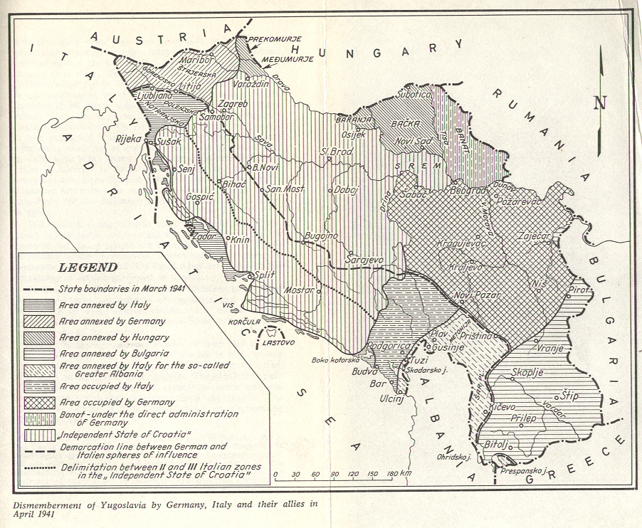
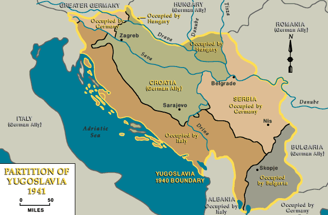
English: Short-lived partisan republics in Yugoslavia in World War II: the Republic of Užice in 1941 and the Republic of Bihać in 1942. Srpskohrvatski / српскохрватски: Kratkotrajne partizanske republike u Jugoslaviji u vreme Drugog svetskog rata: Užička republika (1941) i Bihaćka republika (1942). |
| Date | |
| Source | Own work |
| Author | PANONIAN |
Licensing[edit]
I, the copyright holder of this work, hereby publish it under the following license:
| This file is made available under the Creative Commons CC0 1.0 Universal Public Domain Dedication. | |
| The person who associated a work with this deed has dedicated the work to the public domain by waiving all of their rights to the work worldwide under copyright law, including all related and neighboring rights, to the extent allowed by law. You can copy, modify, distribute and perform the work, even for commercial purposes, all without asking permission.
|
References[edit]
Borders of the Republic of Užice are made in accordance with this source:
- Povijesni atlas za osnovnu školu, Kartografija - Tlos - Zagreb, Zagreb, 1975. (authors of the atlas were Dr Josip Lučić and Prof. Blagota Drašković; associates were Prof. Ivan Kampuš, Prof. Željka Kargačin, Prof. Ivo Makek, Prof. Olga Salzer and Prof. Tomaž Weber; editors were Prof. Zdravko Prelčec and Mr Dragutin Pavličević; reviewers were Prof. Dr Igor Karaman and Dr Ivan Jelić)
Borders of the Republic of Bihać are made in accordance with this source:
- Denis Šehić - Demir Šehić, Istorijski atlas sveta, Beograd, 2007.
Borders of Axis partition of Yugoslavia are made in accordance with these sources:
- Istorijski atlas, Geokarta, Beograd, 1999.
- Školski istorijski atlas, Zavod za izdavanje udžbenika SR Srbije, Beograd, 1970.
- Povijesni atlas, Učila - Zagreb, Zagreb, 1971.
- Denis Šehić - Demir Šehić, Istorijski atlas sveta, Beograd, 2007.
- The Times History of Europe, Times Books, London, 2002.
- Richard Overy, The Times History of the 20th Century, Times Books, London, 2004.
- The Times Atlas svjetske povijesti, Cankarjeva založba, Ljubljana - Zagreb, 1986.
- Tim Džuda, Srbi - istorija, mit i razaranje Jugoslavije, Beograd, 2003.
- Džon R. Lempi, Jugoslavija kao istorija, Beograd, 2004.
- Fransisko Veiga, Balkanska zamka (1804-2001), Beograd, 2003.
- Dr Tomislav Bogavac, Nestajanje Srba, Niš, 1994.
- Valter Manošek, Holokaust u Srbiji, Beograd, 2007.
- http://www.terra.es/personal7/jqvaraderey/194145fc.gif
- http://www.svetskirat.net/slike/razbijanje/zazbijanje_jugoslavije_1941.jpg
- http://www.marxists.org/subject/yugoslavia/images/maps/1941-dismemberment.jpg
- http://www.ushmm.org/lcmedia/map/lc/image/yug71020.gif
- http://www.srpska-mreza.com/MAPS/Yugoslavia/YU-Nazi-division.jpg
- http://www.cartoko.com/content/wp-content/uploads/2010/05/Yugoslavia_1992_p038_CtryStudy.jpg[dead link]
- http://www.arhivyu.gov.rs/Data/Images/06_karta_b.jpg archive copy at the Wayback Machine
- http://terkepek.adatbank.transindex.ro/kepek/netre/211.gif
File history
Click on a date/time to view the file as it appeared at that time.
| Date/Time | Thumbnail | Dimensions | User | Comment | |
|---|---|---|---|---|---|
| current | 17:12, 23 April 2012 | | 1,076 × 1,007 (135 KB) | PANONIAN (talk | contribs) | {{Information |Description ={{en|1=Short-lived partisan republics in Yugoslavia in World War II: The Republic of Užice in 1941 and The Republic of Bihać in 1942.}} |Source ={{own}} |Author =PANONIAN |Date ... |
You cannot overwrite this file.
File usage on Commons
The following 7 pages use this file:
File usage on other wikis
The following other wikis use this file:
- Usage on bs.wikipedia.org
- Usage on cs.wikipedia.org
- Usage on el.wikipedia.org
- Usage on fr.wikipedia.org
- Usage on hr.wikipedia.org
- Usage on it.wikipedia.org
- Usage on ko.wikipedia.org
- Usage on mk.wikipedia.org
- Usage on nl.wikipedia.org
- Usage on no.wikipedia.org
- Usage on pl.wikipedia.org
- Usage on ro.wikipedia.org
- Usage on ru.wikipedia.org
- Usage on sh.wikipedia.org
- Usage on sr.wikipedia.org
- Usage on tr.wikipedia.org
- Usage on uk.wikipedia.org