File:Uruguay T2.png
Bước tới điều hướng
Bước tới tìm kiếm

Kích thước hình xem trước: 527×599 điểm ảnh. Độ phân giải khác: 211×240 điểm ảnh | 422×480 điểm ảnh | 691×786 điểm ảnh.
Tập tin gốc (691×786 điểm ảnh, kích thước tập tin: 1,18 MB, kiểu MIME: image/png)
Chú thích
Chú thích
Ghi một dòng giải thích những gì có trong tập tin này
Miêu tả[sửa]
| Miêu tả |
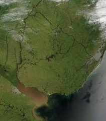
Español: Foto de Uruguay tomada desde satélite. Se aprecian claramente los límites con Brasil y Argentina, y el Río de la Plata al sur.
English: Photo of Uruguay taken from satellite, where the limits with Brazil and Argentina are clearly appreciated, as well as the Río de la Plata to the south. |
| Ngày | |
| Nguồn gốc | http://visibleearth.nasa.gov/view_rec.php?id=4817 |
| Tác giả | Jeff Schmaltz, MODIS Rapid Response Team, NASA/GSFC |
Giấy phép[sửa]
| This file is in the public domain in the United States because it was solely created by NASA. NASA copyright policy states that "NASA material is not protected by copyright unless noted". (See Template:PD-USGov, NASA copyright policy page or JPL Image Use Policy.) | ||
 |
Warnings:
|
Lịch sử tập tin
Nhấn vào ngày/giờ để xem nội dung tập tin tại thời điểm đó.
| Ngày/Giờ | Hình xem trước | Kích cỡ | Thành viên | Miêu tả | |
|---|---|---|---|---|---|
| hiện tại | 04:11, ngày 29 tháng 11 năm 2004 | | 691×786 (1,18 MB) | Tano4595 (thảo luận | đóng góp) | Uruguay_satelite |
Bạn không được phép ghi đè tập tin này.
Trang sử dụng tập tin
3 trang sau sử dụng tập tin này:
Sử dụng tập tin toàn cục
Những wiki sau đang sử dụng tập tin này:
- Trang sử dụng tại af.wikipedia.org
- Trang sử dụng tại als.wikipedia.org
- Trang sử dụng tại an.wikipedia.org
- Trang sử dụng tại ar.wikipedia.org
- Trang sử dụng tại ast.wikipedia.org
- Trang sử dụng tại azb.wikipedia.org
- Trang sử dụng tại ba.wikipedia.org
- Trang sử dụng tại bg.wikipedia.org
- Trang sử dụng tại ca.wikipedia.org
- Trang sử dụng tại cs.wikipedia.org
- Trang sử dụng tại da.wikipedia.org
- Trang sử dụng tại de.wikipedia.org
- Trang sử dụng tại el.wikipedia.org
- Trang sử dụng tại en.wikipedia.org
- Trang sử dụng tại en.wikibooks.org
- Trang sử dụng tại eo.wikipedia.org
- Trang sử dụng tại es.wikipedia.org
- Trang sử dụng tại eu.wikipedia.org
- Trang sử dụng tại fr.wikipedia.org
- Trang sử dụng tại gcr.wikipedia.org
- Trang sử dụng tại hi.wikipedia.org
- Trang sử dụng tại hr.wikipedia.org
- Trang sử dụng tại hu.wikipedia.org
- Trang sử dụng tại hy.wikipedia.org
- Trang sử dụng tại hyw.wikipedia.org
- Trang sử dụng tại is.wikipedia.org
- Trang sử dụng tại it.wikipedia.org
- Trang sử dụng tại ku.wikipedia.org
- Trang sử dụng tại la.wikipedia.org
- Trang sử dụng tại li.wikipedia.org
- Trang sử dụng tại lv.wikipedia.org
- Trang sử dụng tại ms.wikipedia.org
- Trang sử dụng tại mt.wikipedia.org
- Trang sử dụng tại oc.wikipedia.org
- Trang sử dụng tại os.wikipedia.org
- Trang sử dụng tại pcd.wikipedia.org
- Trang sử dụng tại pl.wikipedia.org
Xem thêm các trang toàn cục sử dụng tập tin này.