File:Verlaufskarte Inn DE.png
קפיצה לניווט
קפיצה לחיפוש
גודל התצוגה המקדימה הזאת: 674 × 599 פיקסלים. רזולוציות אחרות: 270 × 240 פיקסלים | 540 × 480 פיקסלים | 864 × 768 פיקסלים | 1,152 × 1,024 פיקסלים | 2,117 × 1,882 פיקסלים.
לקובץ המקורי (2,117 × 1,882 פיקסלים, גודל הקובץ: 5.54 מ"ב, סוג MIME: image/png)
כיתובים
כיתובים
נא להוסיף משפט שמסביר מה הקובץ מייצג
תקציר
[עריכה]
| תיאור |
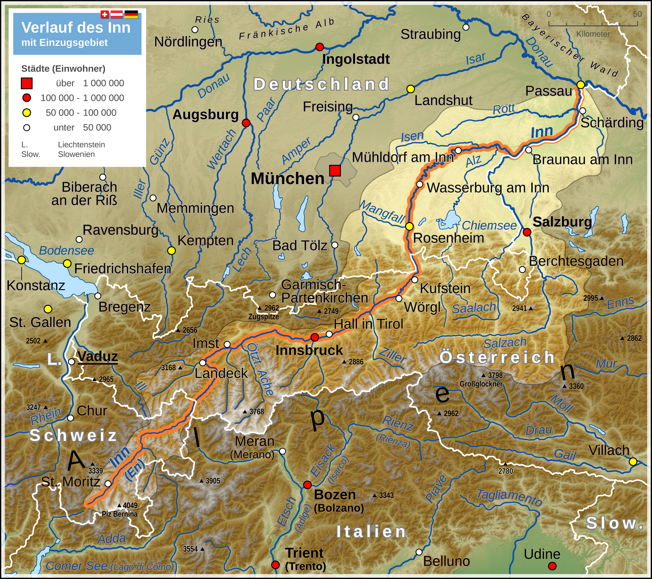
Deutsch: Verlaufskarte des Inn mit Darstellung des Einzugsgebietes
English: Map of Inn river (including drainage basin) |
| תאריך יצירה | |
| מקור |
נוצר על־ידי מעלה היצירה Map created using: |
| יוצר | Thoroe |
| אישורים והיתרים (שימוש חוזר בקובץ זה) |
Map data (c) OpenStreetMap (and) contributors, CC-BY-SA |

|
This map has been made or improved in the German Kartenwerkstatt (Map Lab). You can propose maps to improve as well.
|
רישיון
[עריכה]
הקובץ הזה מתפרסם לפי תנאי רישיון קריאייטיב קומונז ייחוס-שיתוף זהה 2.0 כללי.
ייחוס: Thomas Römer/OpenStreetMap data
- הנכם רשאים:
- לשתף – להעתיק, להפיץ ולהעביר את העבודה
- לערבב בין עבודות – להתאים את העבודה
- תחת התנאים הבאים:
- ייחוס – יש לתת ייחוס הולם, לתת קישור לרישיון, ולציין אם נעשו שינויים. אפשר לעשות את זה בכל צורה סבירה, אבל לא בשום צורה שמשתמע ממנה שמעניק הרישיון תומך בך או בשימוש שלך.
- שיתוף זהה – אם תיצרו רמיקס, תשנו, או תבנו על החומר, חובה עליכם להפיץ את התרומות שלך לפי תנאי רישיון זהה או תואם למקור.
היסטוריית הקובץ
ניתן ללחוץ על תאריך/שעה כדי לראות את הקובץ כפי שנראה באותו זמן.
| תאריך/שעה | תמונה ממוזערת | ממדים | משתמש | הערה | |
|---|---|---|---|---|---|
| נוכחית | 14:41, 6 ביולי 2014 | | 1,882 × 2,117 (5.54 מ"ב) | Thoroe (שיחה | תרומות) | ein paar mehr Flüsse |
| 15:06, 3 במאי 2013 |  | 1,882 × 2,117 (5.52 מ"ב) | Thoroe (שיחה | תרומות) | Einzugsgebiet korrigiert +einige Gewässer | |
| 21:24, 3 באוגוסט 2012 |  | 941 × 1,059 (2 מ"ב) | Kontrollstellekundl (שיחה | תרומות) | Das Standesamt Udine bestätigte für den 31. Januar 2012 erstmals seit 25 Jahren wieder mehr als 100.000 Einwohner - von Gelb auf Rot.<ref>http://messaggeroveneto.gelocal.it/cronaca/2012/02/03/news/udine-torna-sopra-i-100-mila-abitanti-1.3140196</... | |
| 14:48, 18 באוקטובר 2011 |  | 941 × 1,059 (1.88 מ"ב) | Thoroe (שיחה | תרומות) | farbliche Überarbeitung, Details am Einzugsgebiet | |
| 18:31, 9 באוקטובר 2011 |  | 941 × 1,059 (1.84 מ"ב) | Thoroe (שיחה | תרומות) | Einzugsgebiet, Legende reduziert, Geländehöhen, noch ein paar Nebenflüsse etc. | |
| 10:44, 6 באוקטובר 2011 |  | 941 × 1,059 (1.8 מ"ב) | Thoroe (שיחה | תרומות) | mehr Orte und diverse Änderungen | |
| 14:19, 1 באוקטובר 2011 |  | 941 × 1,059 (1.78 מ"ב) | Thoroe (שיחה | תרומות) | {{Information |Description ={{de|1=Verlauf des Inn}} |Source ={{own}} Map created using: *[http://gmt.soest.hawaii.edu Generic Mapping Tools (GMT)] with SRTM3 V2 data *[http://www.openstreetmap.org OpenStreetMap] data *[[:File:Flag |
אין באפשרותך לדרוס את הקובץ הזה.
שימוש בקובץ
הדפים הבאים משתמשים בקובץ הזה:
שימוש גלובלי בקובץ
אתרי הוויקי השונים הבאים משתמשים בקובץ זה:
- שימוש באתר af.wikipedia.org
- שימוש באתר als.wikipedia.org
- שימוש באתר an.wikipedia.org
- שימוש באתר bg.wikipedia.org
- שימוש באתר bs.wikipedia.org
- שימוש באתר cs.wikipedia.org
- שימוש באתר da.wikipedia.org
- שימוש באתר de.wikipedia.org
- שימוש באתר el.wikipedia.org
- שימוש באתר en.wikipedia.org
- שימוש באתר eo.wikipedia.org
- שימוש באתר es.wikipedia.org
- שימוש באתר frr.wikipedia.org
- שימוש באתר fr.wikipedia.org
- שימוש באתר he.wikipedia.org
- שימוש באתר hr.wikipedia.org
- שימוש באתר hu.wikipedia.org
- שימוש באתר hy.wikipedia.org
- שימוש באתר incubator.wikimedia.org
- שימוש באתר it.wikipedia.org
- שימוש באתר ja.wikipedia.org
- שימוש באתר ka.wikipedia.org
- שימוש באתר ko.wikipedia.org
- שימוש באתר lld.wikipedia.org
- שימוש באתר mk.wikipedia.org
- שימוש באתר ml.wikipedia.org
- שימוש באתר nl.wikipedia.org
- שימוש באתר nn.wikipedia.org
- שימוש באתר no.wikipedia.org
- שימוש באתר pl.wikipedia.org
- שימוש באתר pl.wiktionary.org
- שימוש באתר pnb.wikipedia.org
- שימוש באתר rm.wikipedia.org
- שימוש באתר ru.wikipedia.org
- שימוש באתר sco.wikipedia.org
- שימוש באתר sh.wikipedia.org
- שימוש באתר sl.wikipedia.org
צפייה בשימושים גלובליים נוספים של קובץ זה.