File:Vojvodina ethnic2002.png
Jump to navigation
Jump to search

Size of this preview: 506 × 600 pixels. Other resolutions: 202 × 240 pixels | 405 × 480 pixels | 760 × 901 pixels.
Original file (760 × 901 pixels, file size: 177 KB, MIME type: image/png)
Captions
Captions
Add a one-line explanation of what this file represents
Summary[edit]
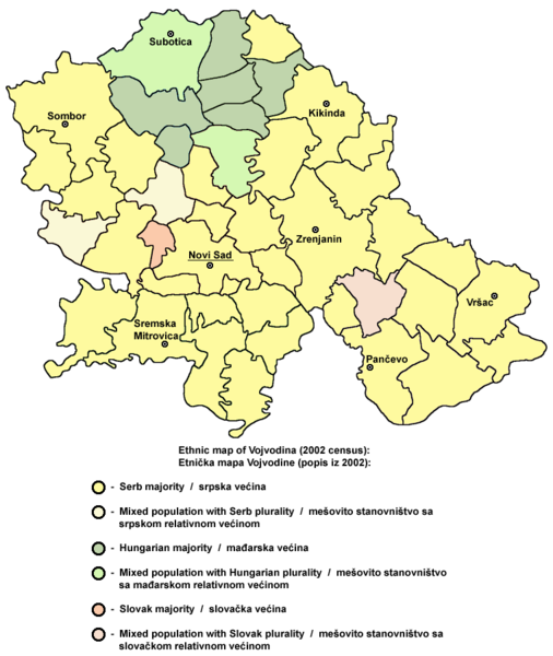
- English: Vojvodina ethnic map - data by municipalities (2002 census)
- Serbian: Етничка мапа Војводине - подаци по општинама (попис из 2002.)
References[edit]
- Popis stanovništva, domaćinstava i stanova u 2002, Stanovništvo, knjiga 1, Nacionalna ili etnička pripadnost - podaci po naseljima, Republika Srbija - Republički zavod za statistiku, Beograd, februar 2003.
- Slobodan Radovanović, Geografski atlas, Magic Map, Smederevska Palanka, 2001.
Source and licence[edit]
Self made map by en:User:PANONIAN
Source: en:File:Vojvodina ethnic2002.png
| This work has been released into the public domain by its author, PANONIAN at English Wikipedia. This applies worldwide. In some countries this may not be legally possible; if so: PANONIAN grants anyone the right to use this work for any purpose, without any conditions, unless such conditions are required by law. |
File history
Click on a date/time to view the file as it appeared at that time.
| Date/Time | Thumbnail | Dimensions | User | Comment | |
|---|---|---|---|---|---|
| current | 15:17, 5 December 2009 | | 760 × 901 (177 KB) | PANONIAN (talk | contribs) | improved version |
| 14:02, 12 June 2009 |  | 800 × 858 (61 KB) | PANONIAN (talk | contribs) | ||
| 20:14, 12 February 2009 |  | 800 × 787 (51 KB) | PANONIAN (talk | contribs) | ||
| 06:36, 23 November 2006 |  | 800 × 787 (44 KB) | Frode Inge Helland (talk | contribs) | Vojvodina ethnic map (self made) Design: Unknown Source: Downloaded from English Wikipedia {{PD-self}} Category:Maps of Vojvodina Category:Ethnic maps |
You cannot overwrite this file.
File usage on Commons
The following page uses this file:
File usage on other wikis
The following other wikis use this file:
- Usage on az.wikipedia.org
- Usage on ba.wikipedia.org
- Usage on be.wikipedia.org
- Usage on bs.wikipedia.org
- Usage on ca.wikipedia.org
- Usage on cs.wikipedia.org
- Usage on da.wikipedia.org
- Usage on dsb.wikipedia.org
- Usage on el.wikipedia.org
- Usage on en.wikipedia.org
- Usage on es.wikipedia.org
- Usage on fr.wikipedia.org
- Usage on hr.wikipedia.org
- Usage on ja.wikipedia.org
- Usage on lt.wikipedia.org
- Usage on nl.wikipedia.org
- Usage on no.wikipedia.org
- Usage on os.wikipedia.org
- Usage on pnb.wikipedia.org
- Usage on ro.wikipedia.org
- Usage on ru.wikipedia.org
- Usage on sh.wikipedia.org
- Usage on sr.wikipedia.org
- Usage on sv.wikipedia.org
- Usage on uk.wikipedia.org
- Usage on zh.wikipedia.org