File:Vongfong 2014 track.png
Jump to navigation
Jump to search

Size of this preview: 800 × 520 pixels. Other resolutions: 320 × 208 pixels | 640 × 416 pixels | 1,024 × 665 pixels | 1,280 × 832 pixels | 2,700 × 1,754 pixels.
Original file (2,700 × 1,754 pixels, file size: 889 KB, MIME type: image/png)
Captions
Captions
Add a one-line explanation of what this file represents
Summary
| Description |
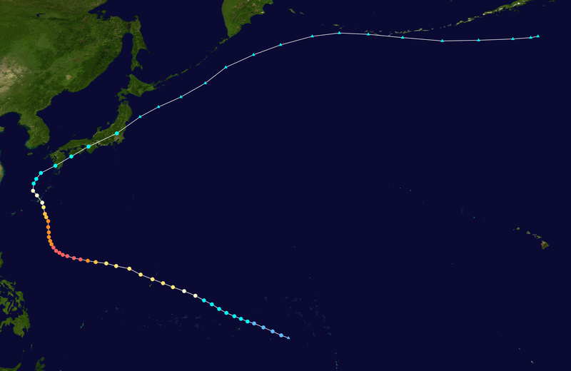
English: Track map of Typhoon Vongfong of the 2014 Pacific typhoon season. The points show the location of the storm at 6-hour intervals. The colour represents the storm's maximum sustained wind speeds as classified in the (see below), and the shape of the data points represent the nature of the storm, according to the legend below. Tropical depression (≤38 mph, ≤62 km/h)
Tropical storm (39–73 mph, 63–118 km/h)
Category 1 (74–95 mph, 119–153 km/h)
Category 2 (96–110 mph, 154–177 km/h)
Category 3 (111–129 mph, 178–208 km/h)
Category 4 (130–156 mph, 209–251 km/h)
Category 5 (≥157 mph, ≥252 km/h)
Unknown
Storm type |
||
| Date | 2014-10-01–2014-10-17 | ||
| Source | Created by Meow using Wikipedia:WikiProject Tropical cyclones/Tracks. The background image is from NASA. Tracking data is from the Joint Typhoon Warning Center[1]. | ||
| Author | Meow | ||
| Source code | Track map data table, if present below, is in HURDAT2 or ATCF format. See format details in [2] and [3], respectively.
|
Licensing
[edit]| This work has been released into the public domain by its author, Meow. This applies worldwide. In some countries this may not be legally possible; if so: Meow grants anyone the right to use this work for any purpose, without any conditions, unless such conditions are required by law. |
File history
Click on a date/time to view the file as it appeared at that time.
| Date/Time | Thumbnail | Dimensions | User | Comment | |
|---|---|---|---|---|---|
| current | 19:26, 14 March 2020 | | 2,700 × 1,754 (889 KB) | Supportstorm (talk | contribs) | JTWC/JMA/OPC data |
| 07:07, 7 January 2020 |  | 2,700 × 2,340 (1.14 MB) | Nino Marakot (talk | contribs) | IBTrACS version + OPC wind data on ET points (ET continuation not documented on any BT) | |
| 04:03, 10 July 2015 |  | 2,700 × 1,754 (1.09 MB) | Cyclonebiskit (talk | contribs) | JTWC best track | |
| 03:34, 22 November 2014 |  | 2,700 × 1,797 (953 KB) | Supportstorm (talk | contribs) | Precise points from OPC graphics/ added missing point | |
| 12:43, 21 November 2014 |  | 2,700 × 1,787 (950 KB) | Meow (talk | contribs) | Extended with the RSMC best track data and the OPC reports. | |
| 04:21, 18 November 2014 |  | 2,700 × 1,794 (945 KB) | Supportstorm (talk | contribs) | Extended extra-tropical track from NOAA OPC | |
| 17:24, 14 October 2014 |  | 2,700 × 2,414 (1.02 MB) | Meow (talk | contribs) | 10-04 06Z (operationally final) | |
| 13:49, 13 October 2014 |  | 2,700 × 2,092 (640 KB) | Meow (talk | contribs) | 10-13 12Z | |
| 13:49, 13 October 2014 |  | 3,000 × 2,325 (768 KB) | Krit-tonkla (talk | contribs) | 10-13 12Z | |
| 13:13, 12 October 2014 |  | 2,700 × 1,843 (422 KB) | Meow (talk | contribs) | 10-12 12Z |
You cannot overwrite this file.
File usage on Commons
The following page uses this file:
File usage on other wikis
The following other wikis use this file:
- Usage on de.wikipedia.org
- Usage on en.wikipedia.org
- Usage on es.wikipedia.org
- Usage on ja.wikipedia.org
- Usage on ko.wikipedia.org
- Usage on pt.wikipedia.org
- Usage on th.wikipedia.org
- Usage on tl.wikipedia.org
- Usage on vi.wikipedia.org
- Usage on www.wikidata.org
- Usage on zh-min-nan.wikipedia.org
- Usage on zh-yue.wikipedia.org
- Usage on zh.wikipedia.org