File:Wales Carmarthenshire locator map.svg
Pereiti į navigaciją
Jump to search

Rinkmenos SVG peržiūros PNG dydisː 502 × 600 taškų. Kitos 6 rezoliucijos: 201 × 240 taškų | 402 × 480 taškų | 643 × 768 taškų | 857 × 1 024 taškų | 1 714 × 2 048 taškų | 1 047 × 1 251 taškų.
Pradinė rinkmena (SVG rinkmena, formaliai 1 047 × 1 251 taškų, rinkmenos dydis: 151 KiB)
Captions
Captions
Add a one-line explanation of what this file represents
Aprašymas[keisti]
| Aprašymas |
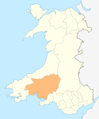
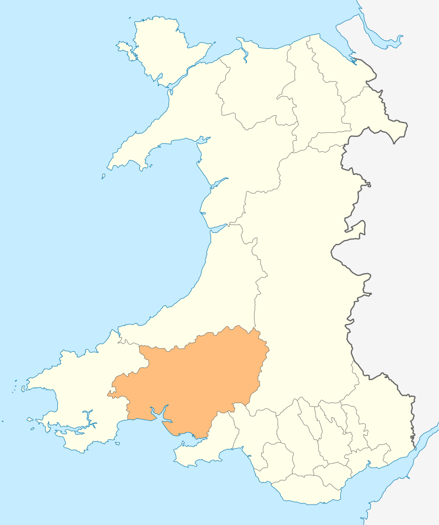
Deutsch: Lagekarte von Carmarthenshire in Wales
English: Locator map of Carmarthenshire in Wales |
| Data | |
| Šaltinis | Mano darbas |
| Autorius | NordNordWest |
| Leidimas (Šios rinkmenos panaudojimas kitur) |
Aš, šio darbo autoriaus teisių savininkas, publikuoju jį su šia licencija: Šiam failui taikoma Creative Commons Attribution-Share Alike 3.0 Unported licencija.
|

|
This map has been made or improved in the German Kartenwerkstatt (Map Lab). You can propose maps to improve as well.
|
Rinkmenos istorija
Paspauskite ant datos/laiko, kad pamatytumėte rinkmeną tokią, kokia ji buvo tuo metu.
| Data/Laikas | Miniatiūra | Matmenys | Naudotojas | Paaiškinimas | |
|---|---|---|---|---|---|
| dabartinis | 18:49, 4 gegužės 2010 | | 1 047 × 1 251 (151 KiB) | NordNordWest (aptarimas | indėlis) | {{int:filedesc}} {{Information |Description= {{de|Lagekarte von Carmarthenshire in Wales}} {{en|Locator map of Carmarthenshire in Wales}} |Source={{Own}} |Date=2010-05-04 |Author={{U|NordNordWest}} |Permission={{self|cc-by-sa-3.0}} |other_versions= }} {{ |
Jūs negalite perrašyti šios rinkmenos.
Rinkmenos naudojimas
Šie puslapiai naudoja šią rinkmeną:
- Template:Carmarthenshire year
- Category:2002 in Carmarthenshire
- Category:2003 in Carmarthenshire
- Category:2004 in Carmarthenshire
- Category:2005 in Carmarthenshire
- Category:2006 in Carmarthenshire
- Category:2007 in Carmarthenshire
- Category:2008 in Carmarthenshire
- Category:2009 in Carmarthenshire
- Category:2010 in Carmarthenshire
- Category:2012 in Carmarthenshire
- Category:2013 in Carmarthenshire
- Category:2014 in Carmarthenshire
- Category:2015 in Carmarthenshire
- Category:2016 in Carmarthenshire
- Category:2017 in Carmarthenshire
- Category:2018 in Carmarthenshire
- Category:2019 in Carmarthenshire
- Category:2020 in Carmarthenshire
- Category:2021 in Carmarthenshire
- Category:2022 in Carmarthenshire
- Category:2023 in Carmarthenshire
- Category:2024 in Carmarthenshire
Visuotinis rinkmenos naudojimas
Ši rinkmena naudojama šiose viki svetainėse:
- Naudojama cs.wikipedia.org
- Naudojama de.wikipedia.org
- Naudojama en.wikipedia.org
- WWT Llanelli Wetlands Centre
- Carmarthenshire
- Sandy, Carmarthenshire
- Llanelli
- Carmarthen
- Llandeilo
- Newcastle Emlyn
- Whitland
- Burry Port
- Kidwelly
- Llandovery
- Laugharne
- St Clears
- Pendine
- Garreg Lwyd (Black Mountain)
- Llandybie
- Llanwrda
- Afon Cothi
- Cwmann
- Bancyfelin
- Talley
- Aber-arad
- Aber-giar
- Abergorlech
- Abernant, Carmarthenshire
- Cross Hands
- Pantyffynnon
- List of places in Carmarthenshire
- Brandy Hill, Wales
- Caio, Carmarthenshire
- Template:Carmarthenshire-geo-stub
- Bryn, Llanelli
- Pemberton, Carmarthenshire
- Dafen, Carmarthenshire
- Pendine Museum of Speed
- Usk Reservoir
- River Cywyn
- Five Roads
- Maesybont
- Glanymor
- Trefawr Track
- Bethlehem, Carmarthenshire
- Stradey
- Cross Inn
- Bronwydd
- Llanfihangel Rhos-y-Corn
- St Ishmael, Carmarthenshire
- Elvet Hundred
Žiūrėti visuotinį šios rinkmenos naudojimą.