File:Zambezi river basin-fi.svg
Jump to navigation
Jump to search

Size of this PNG preview of this SVG file: 800 × 511 pixels. Other resolutions: 320 × 204 pixels | 640 × 409 pixels | 1,024 × 654 pixels | 1,280 × 818 pixels | 2,560 × 1,636 pixels | 2,931 × 1,873 pixels.
Original file (SVG file, nominally 2,931 × 1,873 pixels, file size: 2.12 MB)
Captions
Captions
Add a one-line explanation of what this file represents
Summary[edit]
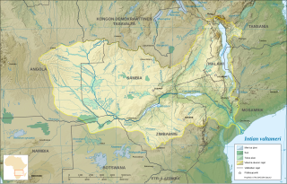
| Description | Map in Finnish of the Zambezi river hydrographic basin, Africa |
| Date | |
| Source |
Own work ; Topographic background map : NASA Shuttle Radar Topography Mission (SRTM30 v.2) (public domain) edited with MicroDEM and dlgv32 Pro / Global Mapper ; UTM projection ; WGS84 datum ; References for the additional data : Demis World Map data (see the approval e-mail and the Demis forum) and UNESCO map ; Locator map : Image:Africa_map_blank.svg (modified) created by myself. |
| Author | Eric Gaba (Sting) |
| Permission (Reusing this file) |
Attribution and Share-Alike required |
Français : * Sujet : Carte en français du bassin hydrographique du Zambèze, Afrique ;
- Sources : Création personnelle
- Fond de carte topographique : NASA Shuttle Radar Topography Mission (SRTM30 v.2) (domaine public) édité avec MicroDEM et dlgv32 Pro / Global Mapper ; projection UTM ; WGS84 datum ;
- Références pour les données complémentaires : Demis World Map data (voir le courriel d'approbation et le forum de Demis) et carte de l'UNESCO ;
- Carte de localisation : Image:Africa_map_blank.svg (modifiée) créée par moi-même ;
- Auteur : Eric Gaba (fr:Sting) ;
- Date : Juillet 2007.

|
This SVG file contains embedded text that can be translated into your language, using any capable SVG editor, text editor or the SVG Translate tool. For more information see: About translating SVG files. |
Licensing[edit]
I, Sting, the copyright holder of this work, hereby publishes it under the following licenses:

|
Permission is granted to copy, distribute and/or modify this document under the terms of the GNU Free Documentation License, Version 1.2 or any later version published by the Free Software Foundation; with no Invariant Sections, no Front-Cover Texts, and no Back-Cover Texts. A copy of the license is included in the section entitled GNU Free Documentation License. |
| This file is licensed under the Creative Commons Attribution-Share Alike 3.0 Unported license. | ||
| Attribution: I, Sting | ||
| ||
| This licensing tag was added to this file as part of the GFDL licensing update. |
This file is licensed under the Creative Commons Attribution-Share Alike 2.5 Generic, 2.0 Generic and 1.0 Generic license.
Attribution: I, Sting
- You are free:
- to share – to copy, distribute and transmit the work
- to remix – to adapt the work
- Under the following conditions:
- attribution – You must give appropriate credit, provide a link to the license, and indicate if changes were made. You may do so in any reasonable manner, but not in any way that suggests the licensor endorses you or your use.
- share alike – If you remix, transform, or build upon the material, you must distribute your contributions under the same or compatible license as the original.
You may select the license of your choice.
File history
Click on a date/time to view the file as it appeared at that time.
| Date/Time | Thumbnail | Dimensions | User | Comment | |
|---|---|---|---|---|---|
| current | 10:52, 23 November 2007 | | 2,931 × 1,873 (2.12 MB) | QWerk (talk | contribs) | == Summary == {{Information |Description=Map in French of the Zambezi river hydrographic basin, Africa |Source=Own work ;<br/>Topographic background map : [http://www2.jpl.nasa.gov/srtm NASA Shuttle Radar Topography Mission] (SRTM30 v.2) (public domain) e |
You cannot overwrite this file.
File usage on Commons
There are no pages that use this file.
File usage on other wikis
The following other wikis use this file:
- Usage on fi.wikipedia.org
- Usage on kk.wikipedia.org
- Usage on ro.wikipedia.org
- Usage on sn.wikipedia.org