File talk:Dux Wasconum 1150.png
Fixing errors and inaccuracies
[edit]
Kaixo Zorion, I'm going through detail, 1150 is the date previous to the Angevin overlordship over Gascony and Aquitaine (1152) and previous to the formation of the Lower Navarre, when the lords of the small seiguneuries cited (Donapaleu, Amikuze...) pledged loyalty to Navarre and not to the Angevins. My information for that area (southern Lower Navarre, Labourd larger than today,...) is for the late 12th century.
The default approach in these cases is to make all the counties suzerain to the duke of Aquitaine, but reality was far more intricate than that, it takes some bibliography browsing. The Auñamendi Entziklopedia entries provide some light on the Basque territories (Historia de Lapurdi, Historia de Zuberoa, Bearn). You can find that Bearn was before the Catalonia-Kingdom of Aragon union (1150) suzerain to Aragon for some time. (Check this Historia de Bearn entry)
Besides, this article is aimed at giving info on the Duchy of Gascony during that period, but should be accurate too on the surrounding area, right? Conspicuously the territories to the west of Navarre hadn't been conquered yet by the Castilian Alfonso VIII, they were Navarrese dependencies extending somewhat further west and south than present-day Basque Autonomous Community (Bureba and Rioja inclusive up to 1173 if I remember well). I can send the boundaries of the south and west of the western Basque districts, but you may find in Eneko del Castillo's work (Nabarlur...). Iñaki LLM (talk) 11:59, 20 December 2013 (UTC)
- O! As I notice too, there is a bold line between Gascony and Navarre/Aragon. Well, if it's about kingdom boundaries should apply then to Navarre too. However, as I said I doubt that at this point Bearn pledged any allegiance to the duke of Gascony, but to Aragon. Unfortunately, I don't have detailed data for Bigorre and Comminges, but may be available somewhere. The title for Labourd and Soule is Vicomté. Auñamendi states and provides evidence that Labourd was a Navarrese creation, but by 1150 that is not so clear, while it points to clashes between Aquitaine and Navarre and local lords over the dependency. However, William IX of Aquitaine seems to have granted a charter to Bayonne, pretty conclusive as to the affiliation of that Basque town at the mid 12th century. Iñaki LLM (talk) 12:29, 20 December 2013 (UTC)
- I wish this is my last shot --Zorion (talk) 20:00, 21 December 2013 (UTC)
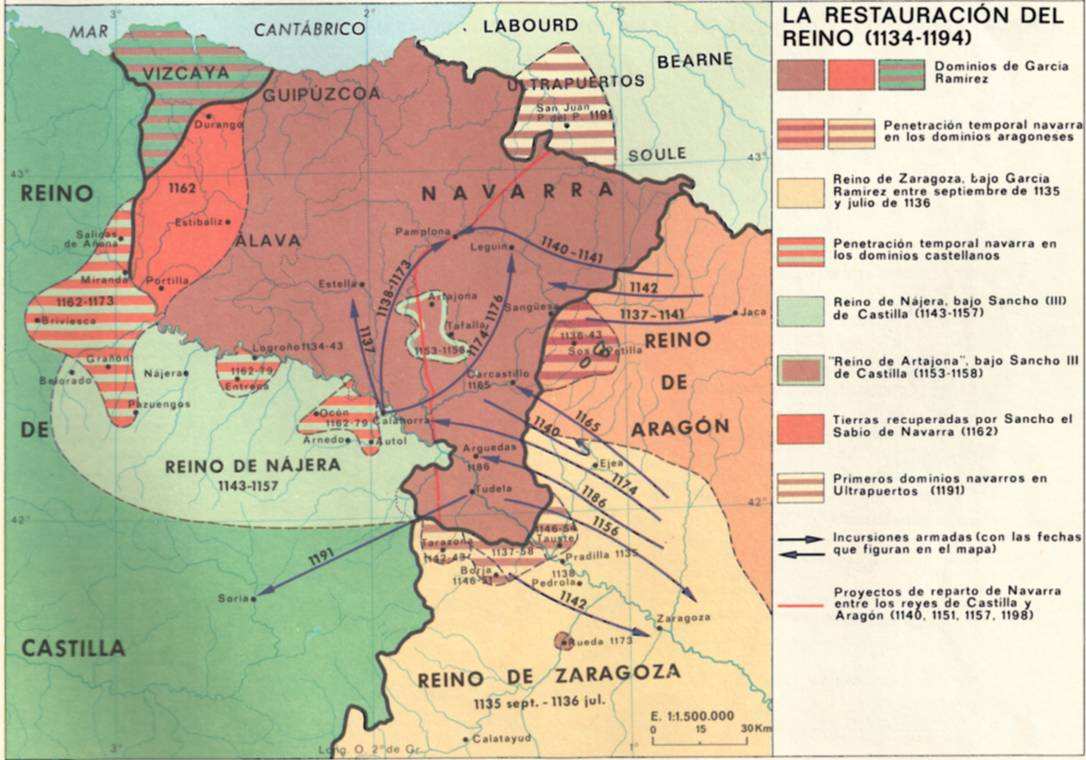
- Not that I have any private interest in this, just my interest in Basque medieval history and trying to save the map added to the Duchy of Gascony. The part of Lower Navarre was fine as you depicted before as far as I am concerned. There were not two kingdoms for Navarre, just Navarre and no Najera. Najera belongs rather to the period up to 1076. Navarre extends south right to the bottom frame of the map with no Aragonese strip of land, and on the west up to about Castro Urdiales, to the west of Bilbao, along the coast, but no Enkarterria (Encartaciones) within Navarre. Checkt out the reference I told you above, I add it here: Eneko del Castillo's dynamic map, the map would belong to the period previous to the 1179 loss of Bureba, and the Rioja. The exact details of the cartography are summarized in La Conquista de Navarra y la Reforma Europea. Pamiela is releasing very interesting and detailed publishing on Navarre, based on Nabarlur's historiography work. If we can save it, that's great, I won't be adding more details anyway. Mila esker eta izan untsa Iñaki LLM (talk) 10:22, 22 December 2013 (UTC)
- Kaixo, You say The part of Lower Navarre was fine as you depicted before as far as I am concerned. But I've found two maps showing a larger Lower Navarre : this map and a map of Manex Goyhenetche (Histoire générale du Pays basque :Préhistoire-Époque Romaine-Moyen-Âge page 254) showing Lapurdi, Lower Navarre and Zuberoa the way I've drawn it, during the reign of Sancho VI of Navarre, and Lower Navarre incorporated into the Kingdom of Navarre in 1194. I took for reference that these lands were not yet part of the kingdom and correspond to the seigneuries. So I'd rather take these two references.
- Concerning the kingdom of Najera, is this map wrong ?
- Also, I want you to tell me what color goes with another, I mean, do I add the same color for a territory with another? I thought you could help me on the map itself, not by adding a long list of historical facts. The dynamic map shows maybe some missing data between 1035 and 1194.
- Why don't you mark down on the map things you want and you don't want, then I can clean that up and do a better look. --Zorion (talk) 16:14, 22 December 2013 (UTC)
- Ok, here you are, I added my version, easier than expected. This is a map on Gascony so I wouldn't attempt to add all the politico-administrative realities outside Gascony, of course Navarre and Aragon are full of smaller districts and seigneuries. As for Najera, this is the first time I hear of it other than the 10-11th century realm. It is usually referred as Castile (Castile's takeover of Navarre's lands across the Ebro...), so it may be a sub-kingdom of Castile. Do as you feel with Lower Navarre (Garazi/Cize was loyal to Navarre at that point, not Amikuze/Mixe, but it was a fast changing reality). At the default of more data on Comminges, Conserans, etc. it's not bad now. And yes, there are stages in between the dynamic map of Nabarlur not showing some periods. Feel free to complete, modify or finetune this version. Iñaki LLM (talk) 21:56, 23 December 2013 (UTC)
- Not that I have any private interest in this, just my interest in Basque medieval history and trying to save the map added to the Duchy of Gascony. The part of Lower Navarre was fine as you depicted before as far as I am concerned. There were not two kingdoms for Navarre, just Navarre and no Najera. Najera belongs rather to the period up to 1076. Navarre extends south right to the bottom frame of the map with no Aragonese strip of land, and on the west up to about Castro Urdiales, to the west of Bilbao, along the coast, but no Enkarterria (Encartaciones) within Navarre. Checkt out the reference I told you above, I add it here: Eneko del Castillo's dynamic map, the map would belong to the period previous to the 1179 loss of Bureba, and the Rioja. The exact details of the cartography are summarized in La Conquista de Navarra y la Reforma Europea. Pamiela is releasing very interesting and detailed publishing on Navarre, based on Nabarlur's historiography work. If we can save it, that's great, I won't be adding more details anyway. Mila esker eta izan untsa Iñaki LLM (talk) 10:22, 22 December 2013 (UTC)
- I wish this is my last shot --Zorion (talk) 20:00, 21 December 2013 (UTC)
Embouchure de l'Adour
[edit]
Il y a une erreur sur l'embouchure de l'Adour qui ne se jette à Bayonne (Anglet/Tarnos) que depuis 1578 suite à des travaux. Le fleuve a changé plusieurs fois d'embouchure mais en 1150 il arrivait dans l'océan à 30 km plus au nord, à Port d'Albret (aujourd'hui Vieux-Boucau-les-Bains), voir L'Adour : histoire, géographie et détournement. --Diddou (talk) 16:05, 22 February 2016 (UTC)
- "L'Adour a été contraint de déplacer son embouchure par la volonté des dunes, remontant plus ou moins loin de Bayonne. Au début de notre ère, il se jetait dans l'Océan à Capbreton, quinze kilomètres plus au nord, en 910 il monte jusqu'à Port-d'Albret, à trente kilomètres ; en 1164, il perce la dune, face à Bayonne, pour peu de temps : Capbreton est élu de nouveau dix ans plus tard, et Port-d'Albret en 1390. Bayonne, ensablée, périclite ; Charles IX ordonne alors de creuser une tranchée dans la dune, face à la ville, qui entend redevenir port de mer. L'opération est réalisée par les habitants sous Henri III ; Louis de Foix, architecte de l'Escurial, la dirige. Le 28 octobre 1578, l'Adour, aidé par une crue de la Nive, se précipite dans la brèche façonnée par les hommes, au droit d'une ville nouvelle, Boucau-Neuf, qui signifie « nouvelle bouche ». Port-d'Albret devient Vieux-Boucau. Bayonne est revigorée. Il ne reste plus qu'à maintenir la brèche ouverte contre vents, sables et marées." --Diddou (talk) 16:19, 22 February 2016 (UTC)
- L'ancien tracé suivait la côte: le fleuve fait une bifurcation vers le nord à Bayonne puis s'écoule à travers ce qui sont aujourd'hui le lac d'Hossegor et le lac marin du Port d'Albret jusqu'à l'océan. --Diddou (talk) 16:19, 22 February 2016 (UTC)
Bonjour Diddou ! Vous pouvez vous-même le faire, c'est un fichier png, donc facile à modifier. --Zorion (talk) 18:09, 23 February 2016 (UTC)
- Je ne sais pas manipuler les images, c'est pour cela que je fais une demande. --Diddou (talk) 20:41, 23 February 2016 (UTC)
Ok, je verrai ça plus tard. --Zorion (talk) 17:17, 24 February 2016 (UTC)