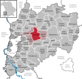
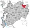
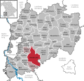
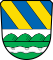
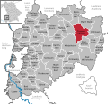
Landkreis Unterallgäu
Jump to navigation
Jump to search
district in Bavaria, Germany    | |||||
| Upload media | |||||
| Instance of |
| ||||
|---|---|---|---|---|---|
| Part of |
| ||||
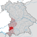
| Location | Swabia, Bavaria, Germany | ||||
| Capital | |||||
| Head of government |
| ||||
| Inception |
| ||||
| Population |
| ||||
| Area |
| ||||
| official website | |||||
 | |||||
located in the administrative territorial entity Bayer. Schwaben (Swabia)
-
 Lage in Deutschland
 -
 Lage im Regierungsbezirk Schwaben / in Bayern

Kommunen[edit]
-
 Kartierung aller Kommunen

Städte[edit]
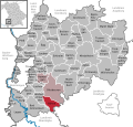
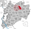
Bad Wörishofen[edit]
Main gallery: Bad Wörishofen.
Main category: Bad Wörishofen
-
 Lage
Lage -
 Wappen
 -
 Luitpold-Leusser-Platz mit Kurhaus
 -
 Brunnen am Kurpark, Pfarrer Sebastian Kneipp zum 76. Geburtstag gewidmet
 -
 Hauptstraße
 -
 Eingang zum Kurhaus
 -
 Im Kurpark
 -
 Kneipp-Brunnen am Denkmalplatz
 -
 Wassertretbecken an der Kneippstraße
 -
 Gradieranlage
 -
 Therme


.JPG)
.JPG)
.JPG)
.JPG)
.JPG)


.JPG)

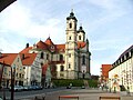
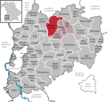
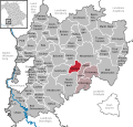
Mindelheim[edit]
Main gallery: Mindelheim.
Main category: Mindelheim
-
 Lage
Lage -
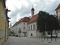
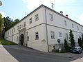
 Landratsamt Unterallgäu
 -
 Blick von der Mindelburg auf die Altstadt mit St. Stephan
 -
 Katholische Kirche St. Stephan
 -
 Kirchplatz von St. Stephan mit Gruftkapelle, Kloster Hl. Kreuz und Turm der ehemaligen Silvesterkirche
 -
 Blick auf eine Straße: die Maximilianstraße mit dem Oberen Tor
 -
 Der „neue“ …
 -
 … und der „alte“ Marienplatz
 -
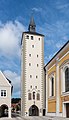
 Oberes Tor
 -
 Unteres Tor
 -
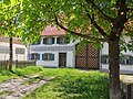
 Maximilianstr. 36


Märkte[edit]
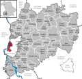
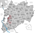
Babenhausen[edit]
Main category: Babenhausen (Swabia)
-
 Lage
Lage -
 Wappen
 -
 Rathaus
 -
 Kirche St. Andreas
 -
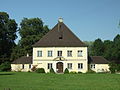 Fürstliches Forsthaus
 -
 Kolpingstrasse 15
 -
 St. Ursus (Klosterbeuren)


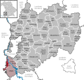
Bad Grönenbach[edit]
Main category: Bad Grönenbach
-
 Lage
Lage -
 Wappen
 -
 Kartierung des Gemeindegebietes
 -
 Rathaus


Dirlewang[edit]
Main category: Dirlewang
-
 Lage
Lage -
 St. Michael
 -
 ehemalige Tafernwirtschaft


Erkheim[edit]
Main category: Erkheim
-
 Lage
Lage -
 Wappen
 -
 Mariä Himmelfahrt
 -
 Günztalstraße
 -
 evangelische Pfarrkirche Peter und Paul
 -
 Bauernhaus in Erkheim
 -
 Daxberg von Südosten
 -
 Knaus
Knaus -
 Bürogebäude „Holzkopf“ der Firma Baufritz von Diether Kunerth


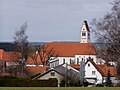
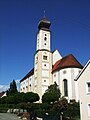
Kirchheim in Schwaben[edit]
Main category: Kirchheim in Schwaben
-
 Lage
Lage -
 Wappen
 -
 von Süden aus betrachtet
 -
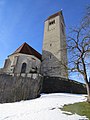
 uggerschloß Kirchheim in Schwaben
 -
 Historisches Rathaus Kirchheim in Schwaben
 -
 Marktplatz mit Denkmal Johannes von Nepomuk
 -
 ehemaliges Dominikanerkloster unterhalb von Kirche und Schloss
 -
 Marktplatz mit Gasthof Adler
 -
 Apotheke


_02.JPG)
_01.JPG)
_01.JPG)
_02.JPG)
_01.JPG)
Legau[edit]
Main category: Legau
-
 Lage
Lage -
 Wappen
 -
 Legau
Legau -
 von Osten
 -
 Wallfahrtskirche Maria Steinbach
 -
 Lehenbühl
 -
 Illersteg Legau


.jpg)


.jpg)
Markt Rettenbach[edit]
Main category: Markt Rettenbach
-
 Lage
Lage -
 Wappen
 -
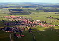
 Eutenhausen von Norden
 -
 Kirche in Engetried
 -
 Flohkraut
 -
 Gottenau und Frechenrieden
 -
 Griesthal
 -
 Günztal südlich von Engetried
 -
 Markt Rettenbach
 -
 Markt Rettenbach von Westen
 -
 Klosterkirche Mussenhausen
 -
 Wineden


Markt Wald[edit]
Main category: Markt Wald
-
 Lage
Lage -
 Wappen
 -
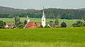
 Ortsansicht
 -
 Kapelle St. Antonius von Padua in Schnerzhofen von Norden
 -
 Pfarrkirche Mariä Himmelfahrt


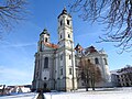
Ottobeuren[edit]
Main category: Ottobeuren
-
 Lage
Lage -
 Wappen
 -
 Basilika und Marktplatz
 -
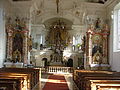
 Deckenfresko in der Basilika
 -
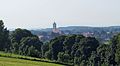
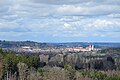 Ottobeuren von Südosten
 -
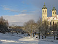 Basilika in Ottobeuren im Winter


Pfaffenhausen[edit]
Main category: Pfaffenhausen
-
 Lage
Lage -
 Wappen
 -
 Ortskarte
 -
 Ortsansicht
 -
 Pfarrkirche St. Stephan


Türkheim[edit]
Main category: Türkheim
-
 Lage
Lage -
 Wappen
 -
 Pfarrkirche und ehemaliges Waaghaus in Türkheim
 -
 Ortsansicht
 -
 Panorama mit Zugspitze
 -
 ehemalige Römerschanze im Norden


Tussenhausen[edit]
Main category: Tussenhausen
-
 Lage
Lage -
 Wappen
 -
 Tussenhausen von Norden
 -
 Marktplatz
 -
 Rathaus
 -
 Pfarrhof und Kirche in Zaisertshofen
 -
 Mariä Himmelfahrt (Mattsies)


Sonstige[edit]
-
 AmbergMain category: Amberg (Unterallgäu)
 -
 ApfeltrachMain category: Apfeltrach
 -

-
-
 BoosMain category: Boos (Schwaben)
 -
 BreitenbrunnMain category: Breitenbrunn (Schwaben)
 -
 BuxheimMain category: Buxheim (Schwaben)
 -
 Egg an der GünzMain category: Egg an der Günz
 -
 EttringenMain category: Ettringen (Wertach)
 -

-

-
 HeimertingenMain category: Heimertingen
 -

-

-
 KettershausenMain category: Kettershausen
 -
 KirchhaslachMain category: Kirchhaslach
 -

-
 LachenMain category: Lachen (Schwaben)
 -
 LaubenMain category: Lauben (Landkreis Unterallgäu)
 -
-
 MemmingerbergMain category: Memmingerberg
 -
 NiederriedenMain category: Niederrieden
 -
 OberriedenMain category: Oberrieden (Schwaben)
 -
 OberschöneggMain category: Oberschönegg
 -

-
 RammingenMain category: Rammingen (Bayern)
 -
-
 SontheimMain category: Sontheim (Schwaben)
 -
 StettenMain category: Stetten (Schwaben)
 -
 TrunkelsbergMain category: Trunkelsberg
 -
 UngerhausenMain category: Ungerhausen
 -

-
 WesterheimMain category: Westerheim (Schwaben)
 -
 WiedergeltingenMain category: Wiedergeltingen
 -
 WinterriedenMain category: Winterrieden
 -
 WolfertschwendenMain category: Wolfertschwenden
 -


Verschiedenes[edit]
-
 Landkreis-Schild
 -
 Fuggerschloss Babenhausen in Schwaben
 -
 Basilika in Ottobeuren von Nordwesten
 -
 Unterallgäuer Bauernhof mit typischem Korbbogentor
 -
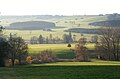
 Mittelschwäbische Landschaft bei Eppishausen
 -
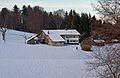
 Bei Bedernau im nördlichen Landkreis
 -
 Hawangen und Klosterkirche Ottobeuren vor der Mieminger Kette
 -
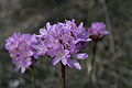 Die Riednelke im Benninger Ried, dem weltweit einzigen Platz, wo sie noch wächst
 -
 Mindeltal bei Unteregg


Urban districts (cities): Amberg · Ansbach · Aschaffenburg · Augsburg · Bamberg · Bayreuth · Coburg · Erlangen · Fürth · Hof · Ingolstadt · Kaufbeuren · Kempten · Landshut · Memmingen · Munich · Nuremberg · Passau · Regensburg · Rosenheim · Schwabach · Schweinfurt · Straubing · Weiden in der Oberpfalz · Würzburg
