Larvik
Jump to navigation
Jump to search
Norsk bokmål: Larvik er en by i Vestfold fylke, Norge.
English: Larvik is a town in Vestfold county, Norway.
Panoramic views
[edit]-
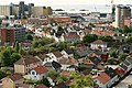
 Larvik
 -
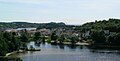
 Torstrand
 -
 Østre Halsen


Buildings
[edit]Churches
[edit]-
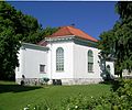
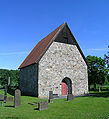 Berg old church
 -
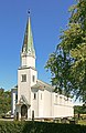 Berg kirke
 -
 Langestrand kirke
 -
 Tanum kirke
 -
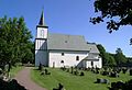
 Tjølling kirke


Schools
[edit]-
 Berg skole
 -
 Mesterfjellet skole
 -
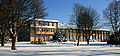 Thor Heyerdahl videregående (Larvik gymnas)
 -
 Torstrand skole


Other public buildings
[edit]-
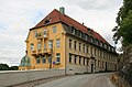
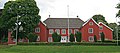 Herregården
 -
 Town hall
 -
 Hospitalet
 -
 Larvik museum
 -
 Sjøfartsmuseet


Industrial buildings
[edit]-
 Felleskjøpet
 -
 Farrisfabrikken


Farms
[edit]-
 Tanum gård, Brunlanes
 -
 Tanum prestegård
 -
 Odberg. 1946


Streets and places
[edit]-
 Torget.
The market. -
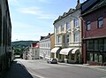 Kongegata
 -
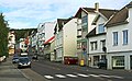 Prinsegata


Parks
[edit]-
 Bøkeskogen.
The Beach forest.

Villages
[edit]Nevlunghavn
[edit]
Landscapes
[edit]-
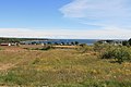 Brunlanes, Omrebukta

Sea, beach, harbour
[edit]-

-
-
 Røvikfjorden, Brunlanes


Lakes and rivers
[edit]-
 Farriselva, lower course
 -
 Hallevannet


Maps
[edit]-

-
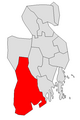 Location in Vestfold county


Coats of arms
[edit]
.jpg)
Misc.
[edit]-
 Fritzøe airfield
 -
 Fritzøe airfield
 -
 Larvikitt (mørk labrador)
 -
 Larvikitt (lys labrador)


