Maramureş
Jump to navigation
Jump to search
Deutsch: Die Maramuresch ist eine Landschaft im nordrumänischen Kreis Maramureș und dem ukrainischen Oblast Transkarpatien, die im Kaiserreich die Verwaltungseinheit Komitat Máramaros bildete.
English: Maramureș — a region of northern Transylvania, in northwestern Romania and western Ukraine.
- Location of Maramureș County (Romania) and Zakarpattia Oblast (Ukraine).
Română: Maramureș este o regiune în nordul Transilvaniei, în nord-vestul României și vestul Ucrainei.
Landscapes / mountain ranges | Landschaft / Berge
[edit]See also: Category:Maramureş Mountains
-
 English: Category:Munţii Maramureşului
 -
 English: Category:Farcău
 -
 English: Category:Cerneşti, Maramureş
 -
 English: Category:Lăpuşul Românesc


.jpg)

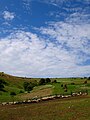
Vegetation | Vegetation
[edit]-
 English: Springflowers near Botiza

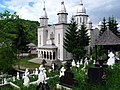
Sacral architecture | Sakrale Architektur
[edit]See also: Category:Romanian Orthodox churches in Maramureş County | Category:Wooden churches in Maramureş County
-
 English: Monastery Botiza (1998)
 -
 English: New church in Botiza
 -
 English: Rectory in Botiza
 -

-
 English: Bistra
 -


Rural architecture | Ländliche Architektur
[edit]See also: Category:Farm buildings in Maramureş County


Profane architecture | Profane Architektur
[edit]
Clickable Map of the Maramureş County, 1782-1785
[edit]