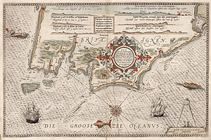
Nautical chart of the 16th century showing western Brittany (France). This map was published in the world's first printed maritime atlas, the Spieghel der zeevaerdt (Navigation Mirror) by Dutch cartographer Lucas Janszoon Waghenaer.
This is the English translation of the Picture of the day description page from 11 April 2022.
Nautical chart of the 16th century showing western Brittany (France). This map was published in the world's first printed maritime atlas, the Spieghel der zeevaerdt (Navigation Mirror) by Dutch cartographer Lucas Janszoon Waghenaer.