User:National Library of Israel/Maps
Jump to navigation
Jump to search

John Rapkin Map[edit]

De Pierre Map[edit]

Breydenbach Map[edit]
Nolin Map[edit]

Vilna Gaon Map[edit]

Canaan with Bordering Nations[edit]

Sieber Map[edit]

Derech Emeth[edit]


Van De Velde Map[edit]


Hadera Map[edit]
-
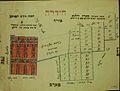 Hadera map sketch

-
 The Madaba Mosaic Map-A mosaic covering part of the floor of a late sixth-century Byzantine Church in Madaba (today in Jordan) representing the Holy Land and the surrounding countries
 -
 The first Palestine map of Ortelius
 -
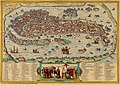 Venice Map from 1572


Acre[edit]
-
 Civitas Acon sive Ptolomaida-Acre 1500
 -
 Chaifa e S.Gio: Dachiri-Haifa 1770


Bethlehem[edit]
-
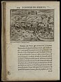
 The way betweene Ierusalem and Bethlem 1621
 -
 Bethlehem Cite de David, et Ville de Judee, ou N. Seigneur prit Naissance 1760


Carmel[edit]
-
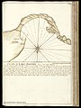
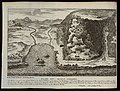
 A Plan of Mount Carmel
 -
 Mount Carmel


Jaffa[edit]
-
 Old map of Jaffa from 1587
 -
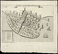
 Old map of Jaffa


Nazareth[edit]
-
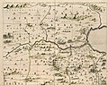
 Old map of Nazareth from 1657
 -
 Old map of Nazareth from 1681


Ramla[edit]
-
 Old map of Ramla from 1587
 -
 Old map of Ramla from 1657
_1587.jpg)
_1657.jpg)
Rehovot[edit]
-
 A Plan of Rehovot 1897

Mount Tabor[edit]
-
 A map of Mount Tabor from 1714
 -
 A map of Mount Tabor from 1677


Terre sainte[edit]
-
 A map of the Land of Israel from 1729
 -
 A map of the Land of Israel from 1729
 -
 A map of Israel from 1637
 -
 A map of Israel from 1639


Tribes of Israel[edit]
-
 A map of the land of the tribe of Asher, One of the twelve Israel tribes
 -
 A map describing Tribes of Israel from 1658
 -
 A map of a Tribe of Simeon. One of the twelve tribes of Israel from 1658
 -
 A map of the Tribes of Benjamin and Ephraim from 1658


