Category:Donauwörth
Jump to navigation
Jump to search
city in Bavaria, Germany    | |||||
| Upload media | |||||
| Instance of |
| ||||
|---|---|---|---|---|---|
| Part of |
| ||||
| Location | Donau-Ries, Swabia, Bavaria, Germany | ||||
| Located in or next to body of water | |||||
| Head of government |
| ||||
| Inception |
| ||||
| Population |
| ||||
| Area |
| ||||
| Elevation above sea level |
| ||||
| official website | |||||
 | |||||
Subcategories
This category has the following 23 subcategories, out of 23 total.
Media in category "Donauwörth"
The following 37 files are in this category, out of 37 total.
-
De-Donauwörth.ogg 2.0 s; 19 KB
-
 2010-09-04 Schwaebische Alb HW1 HW2 Donauwoerth.jpg 1,536 × 2,048; 682 KB
-
 Albrandweg Streckenverlauf Donauwörth.jpg 734 × 1,024; 545 KB
-
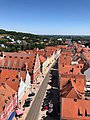 Blick vom Münsterturm über die Reichsstraße in Donauwörth.jpg 959 × 1,280; 329 KB
-
 DONAUWOERTH nieder.png 480 × 360; 5 KB
-
 DONAUWOERTH nieder.svg 512 × 427; 21 KB
-
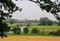 Donauwoerth Woernitz-2.jpg 1,400 × 955; 392 KB
-
 Donauwörth - Kalvarienberg - Donauwörth v NO 01.jpg 4,371 × 2,363; 1.24 MB
-
 Donauwörth - Münster links, Heiligkreuzkirche, Wörnitz.jpg 3,584 × 2,016; 782 KB
-
 Donauwörth - Münster und Heilig-Kreuz-Kirche rechts.jpg 3,584 × 2,016; 751 KB
-
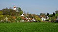 Donauwörth - Wörnitzstein mit Kapelle.jpg 3,542 × 1,941; 849 KB
-
 Donauwörth 001.jpg 4,712 × 3,142; 6.71 MB
-
 Donauwörth im Abendlicht.JPG 2,304 × 1,728; 743 KB
-
 Donauwörth Jakobsweg 253.jpg 4,394 × 2,929; 9.53 MB
-
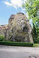 Donauwörth Mangoldfelsen 002.jpg 3,956 × 5,950; 15.56 MB
-
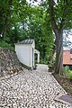 Donauwörth Sternschanze 02.jpg 3,955 × 5,948; 15.73 MB
-
 Donauwörth Sternschanze 03.jpg 3,900 × 5,865; 13.51 MB
-
 Donauwörth Städtepartnerschaft 252.jpg 4,549 × 3,032; 14.56 MB
-
 Donauwörth-Freilichtbühne1-Asio.JPG 3,456 × 2,304; 2.21 MB
-
 DOP40 - Landkreis Donau-Ries 32628 5397 (Bayerische Vermessungsverwaltung).tif 2,500 × 2,500; 18.61 MB
-
 DOP40 - Landkreis Donau-Ries 32630 5398 (Bayerische Vermessungsverwaltung).tif 2,500 × 2,500; 17.58 MB
-
 DOP40 - Landkreis Donau-Ries 32631 5396 (Bayerische Vermessungsverwaltung).tif 2,500 × 2,500; 15.16 MB
-
 DOP40 - Landkreis Donau-Ries 32631 5397 (Bayerische Vermessungsverwaltung).tif 2,500 × 2,500; 17.96 MB
-
 DOP40 - Landkreis Donau-Ries 32631 5398 (Bayerische Vermessungsverwaltung).tif 2,500 × 2,500; 17.62 MB
-
 DOP40 - Landkreis Donau-Ries 32631 5399 (Bayerische Vermessungsverwaltung).tif 2,500 × 2,500; 18.57 MB
-
 DOP40 - Landkreis Donau-Ries 32631 5400 (Bayerische Vermessungsverwaltung).tif 2,500 × 2,500; 18.02 MB
-
 DOP40 - Landkreis Donau-Ries 32632 5397 (Bayerische Vermessungsverwaltung).tif 2,500 × 2,500; 15.87 MB
-
 DOZEMODE.jpg 1,536 × 1,536; 560 KB
-
 Einwohnerentwicklung von Donauwörth.svg 800 × 400; 50 KB
-
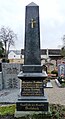
 Grabstätte Egk.jpg 1,440 × 2,000; 552 KB
-
-
 Historico-Topographica Descriptio. 1. Das Renntambt München 560.jpg 18,463 × 7,846; 23.61 MB
-
 Kirchengang.jpg 3,648 × 2,724; 6.22 MB
-
 Ortsschild Donauwoerth.jpg 3,000 × 4,000; 5.17 MB
-
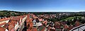 Panoramablick vom Donauwörther Münsterturm nach Südosten.jpg 1,280 × 468; 114 KB
-
 Panzergrenadiere 8 der Bundeswehr 1968.jpg 3,264 × 2,267; 482 KB
-
 Schwabenalb S109B, Donauwörth Donaubrücke Wörnitz, Traber.jpg 2,000 × 1,321; 770 KB


