File:Azimuthal equidistant projection SW.jpg
Jump to navigation
Jump to search

Size of this preview: 600 × 600 pixels. Other resolutions: 240 × 240 pixels | 480 × 480 pixels | 768 × 768 pixels | 1,024 × 1,024 pixels | 2,058 × 2,058 pixels.
Original file (2,058 × 2,058 pixels, file size: 975 KB, MIME type: image/jpeg)
Captions
Captions
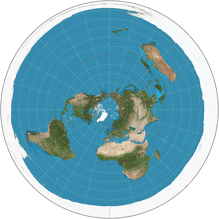
The world on azimuthal equidistant projection, north polar view.
|
Summary[edit]
| Description |
English: The world on azimuthal equidistant projection. 15° graticule, polar aspect. Imagery is a derivative of NASA’s Blue Marble summer month composite with oceans lightened to enhance legibility and contrast. Image created with the Geocart map projection software. |
| Date |
|
| Source | Own work |
| Author | Strebe |
Licensing[edit]
I, the copyright holder of this work, hereby publish it under the following license:
This file is licensed under the Creative Commons Attribution-Share Alike 3.0 Unported license.
- You are free:
- to share – to copy, distribute and transmit the work
- to remix – to adapt the work
- Under the following conditions:
- attribution – You must give appropriate credit, provide a link to the license, and indicate if changes were made. You may do so in any reasonable manner, but not in any way that suggests the licensor endorses you or your use.
- share alike – If you remix, transform, or build upon the material, you must distribute your contributions under the same or compatible license as the original.
File history
Click on a date/time to view the file as it appeared at that time.
| Date/Time | Thumbnail | Dimensions | User | Comment | |
|---|---|---|---|---|---|
| current | 22:17, 15 August 2011 | | 2,058 × 2,058 (975 KB) | Strebe (talk | contribs) |
You cannot overwrite this file.
File usage on Commons
The following page uses this file:
File usage on other wikis
The following other wikis use this file:
- Usage on ar.wikipedia.org
- Usage on bn.wikipedia.org
- Usage on cs.wikipedia.org
- Usage on de.wikipedia.org
- Usage on en.wikipedia.org
- User talk:Strebe
- World map
- Azimuthal equidistant projection
- Talk:Azimuthal equidistant projection
- Wikipedia:Featured pictures/Diagrams, drawings, and maps/Maps
- User talk:Cowtowner
- List of map projections
- Wikipedia:Featured pictures thumbs/35
- Wikipedia:Featured picture candidates/June-2013
- Wikipedia:Featured picture candidates/Map Projections Set
- User:R. Portela F.
- Wikipedia:Picture of the day/May 2016
- Template:POTD/2016-05-19
- Wikipedia:Main Page history/2016 May 19
- Template:User Flat Earth
- Interruption (map projection)
- Portal:Geography/Selected picture
- User:Hades699
- Usage on en.wiktionary.org
- Usage on es.wikipedia.org
- Usage on et.wikipedia.org
- Usage on eu.wikipedia.org
- Usage on fr.wikipedia.org
- Usage on fr.wikiversity.org
- Usage on ha.wikipedia.org
- Usage on he.wikipedia.org
- Usage on hu.wikipedia.org
- Usage on hy.wikipedia.org
- Usage on id.wikipedia.org
- Usage on it.wikipedia.org
- Usage on nl.wikipedia.org
- Usage on pnb.wikipedia.org
- Usage on pt.wikipedia.org
- Usage on ru.wikipedia.org
- Usage on th.wikipedia.org
- Usage on uk.wikipedia.org
View more global usage of this file.