File:2009-09-29 Samoa Island Region earthquake location.jpg
Jump to navigation
Jump to search
No higher resolution available.
2009-09-29_Samoa_Island_Region_earthquake_location.jpg (420 × 468 pixels, file size: 57 KB, MIME type: image/jpeg)
Captions
Captions
Add a one-line explanation of what this file represents


Summary[edit]
| Description |
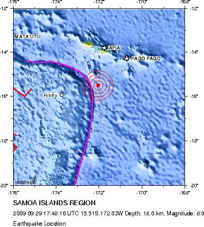
English: Earthquake location map. Major Tectonic Boundaries: Subduction Zones -purple, Ridges -red and Transform Faults -green
Deutsch: Erdbebenlagekarte. |
| Date | |
| Source | http://neic.usgs.gov/neis/eq_depot/2009/eq_090929_mdbi/neic_mdbi_l.html |
| Author | United States Geological Survey |
Licensing[edit]
This image is in the public domain in the United States because it only contains materials that originally came from the United States Geological Survey, an agency of the United States Department of the Interior. For more information, see the official USGS copyright policy.
|
File history
Click on a date/time to view the file as it appeared at that time.
| Date/Time | Thumbnail | Dimensions | User | Comment | |
|---|---|---|---|---|---|
| current | 15:05, 1 October 2009 | | 420 × 468 (57 KB) | Avenue (talk | contribs) | Updated version from USGS website: http://neic.usgs.gov/neis/eq_depot/2009/eq_090929_mdbi/neic_mdbi.jpg Created by USGS, so public domain. |
| 20:52, 29 September 2009 |  | 420 × 468 (57 KB) | Matthiasb (talk | contribs) | {{Information |Description={{en|1=Earthquake location map. Major Tectonic Boundaries: Subduction Zones -purple, Ridges -red and Transform Faults -green}} {{de|1=Erdbebenlagekarte. }} |Source=http://neic.usgs.gov/neis/eq_depot/2009/eq_090929_mdbi/neic_mdbi |
You cannot overwrite this file.
File usage on Commons
The following 2 pages use this file:
File usage on other wikis
The following other wikis use this file:
- Usage on de.wikipedia.org
- Usage on de.wikinews.org
- Usage on en.wikinews.org
- Usage on es.wikipedia.org
- Usage on es.wikinews.org
- Usage on eu.wikipedia.org
- Usage on fi.wikipedia.org
- Usage on fr.wikipedia.org
- Usage on he.wikipedia.org
- Usage on hif.wikipedia.org
- Usage on it.wikipedia.org
- Usage on ja.wikipedia.org
- Usage on ms.wikipedia.org
- Usage on nl.wikipedia.org
- Usage on no.wikipedia.org
- Usage on pl.wikipedia.org
- Usage on pl.wikinews.org
- Usage on pt.wikipedia.org
- Usage on pt.wikinews.org
- Usage on ro.wikipedia.org
- Usage on th.wikipedia.org
- Usage on www.wikidata.org
- Usage on zh.wikipedia.org