File:Karta öfver landswägarne uti Sverige och Norige LOC 2015591081.tif
Jump to navigation
Jump to search

Size of this JPG preview of this TIF file: 420 × 599 pixels. Other resolutions: 168 × 240 pixels | 336 × 480 pixels | 538 × 768 pixels | 717 × 1,024 pixels | 1,435 × 2,048 pixels | 7,745 × 11,054 pixels.
Original file (7,745 × 11,054 pixels, file size: 244.94 MB, MIME type: image/tiff)
Captions
Captions
Add a one-line explanation of what this file represents
Summary
[edit]| Warning | The original file is very high-resolution. It might not load properly or could cause your browser to freeze when opened at full size. |
|---|
| Description |
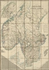
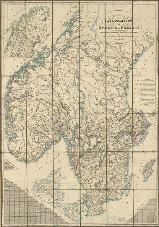
English: Relief shown by hachures. Also shows administrative counties (läner and amter). Prime meridian: Ferro [?]. Signed in ink on paper slip affixed to verso: Millard Fillmore, May 8 1856. LC copy imperfect: Sectioned to 36 panels to enable folding. Includes inset of northern Sweden/Norway and 3 highway distance tables. Available also through the Library of Congress Web site as a raster image. Vault |
||
| Title | Karta öfver landswägarne uti Sverige och Norige | ||
| Shelf ID | G6951.P2 1843 .B7 | ||
| Date | |||
| Source | https://www.loc.gov/item/2015591081/ | ||
| Author | Brandenburg, L. W. (Lorens Wilhelm); Fillmore, Millard; Sweden. Kongl. Gen. Landtm. Contoret | ||
| Permission (Reusing this file) |
|
||
| Other versions |
|
||
| Location | Sweden · Norway · Sweden. · Norway. | ||
| Part of | American Memory · Catalog · Transportation And Communication · Geography And Map Division | ||
| Subject | Maps · Sweden · Counties · Roads · Norway · Road Maps |


Licensing
[edit]|
This is a faithful photographic reproduction of a two-dimensional, public domain work of art. The work of art itself is in the public domain for the following reason:
The official position taken by the Wikimedia Foundation is that "faithful reproductions of two-dimensional public domain works of art are public domain".
This photographic reproduction is therefore also considered to be in the public domain in the United States. In other jurisdictions, re-use of this content may be restricted; see Reuse of PD-Art photographs for details. | ||||
File history
Click on a date/time to view the file as it appeared at that time.
| Date/Time | Thumbnail | Dimensions | User | Comment | |
|---|---|---|---|---|---|
| current | 13:41, 1 June 2018 |  | 7,745 × 11,054 (244.94 MB) | Fæ (talk | contribs) | LOC Maps https://www.loc.gov/item/2015591081/ #1584 |
You cannot overwrite this file.
File usage on Commons
The following page uses this file: