Category:Cat and Fiddle Inn, Cheshire
Jump to navigation
Jump to search
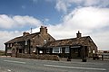
the second-highest pub in England  Cat and Fiddle Inn  | |||||
| Upload media | |||||
| Instance of | |||||
|---|---|---|---|---|---|
| Location | Macclesfield Forest and Wildboarclough, Cheshire East, Cheshire, North West England, England | ||||
| Street address |
| ||||
 | |||||
Media in category "Cat and Fiddle Inn, Cheshire"
The following 43 files are in this category, out of 43 total.
-
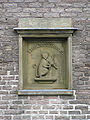
 Carving, Cat and Fiddle - geograph.org.uk - 175875.jpg 480 × 640; 141 KB
-
 Cat & Fiddle on the horizon - geograph.org.uk - 1950199.jpg 640 × 480; 54 KB
-
 Cat and Fiddle - geograph.org.uk - 3476084.jpg 2,048 × 1,536; 662 KB
-
 Cat and Fiddle - geograph.org.uk - 4097878.jpg 3,517 × 2,030; 1.63 MB
-

-
 Cat and Fiddle Inn - geograph.org.uk - 1093639.jpg 640 × 385; 51 KB
-
 Cat And Fiddle Inn - geograph.org.uk - 4070551.jpg 2,560 × 1,438; 1.93 MB
-
 Cat and Fiddle Inn on A537 - geograph.org.uk - 3511802.jpg 4,000 × 2,248; 3.89 MB
-
 Cat and Fiddle Inn plaque - geograph.org.uk - 3507393.jpg 501 × 800; 146 KB
-

-
 Cat and Fiddle Pub - geograph.org.uk - 2944086.jpg 1,280 × 853; 290 KB
-
 Cat and Fiddle pub sign cropped.jpg 515 × 503; 78 KB
-
 Cat and Fiddle pub sign.jpg 3,648 × 2,736; 2.87 MB
-
 Cat and Fiddle road from Shining Tor.jpg 4,128 × 3,096; 2.88 MB
-
 Cat and Fiddle. Northern Aspect - geograph.org.uk - 4180133.jpg 640 × 480; 68 KB
-
 Cat ^ Fiddle - geograph.org.uk - 2719367.jpg 2,592 × 1,944; 1.93 MB
-
 CatAndFiddleDetail (cropped).jpg 736 × 872; 100 KB
-
 CatAndFiddleDetail.jpg 960 × 1,280; 293 KB
-
 CatAndFiddlePH.jpg 1,144 × 858; 211 KB
-
 Cheshire, The 'Cat and Fiddle' public house - geograph.org.uk - 3118768.jpg 3,324 × 2,470; 5.6 MB
-
 Fingerpost at top of Stakeside path - geograph.org.uk - 1740824.jpg 480 × 640; 62 KB
-
 Last lap to the Cat and Fiddle - geograph.org.uk - 600676.jpg 477 × 640; 45 KB
-
 Mast beside the Cat and Fiddle - geograph.org.uk - 2025590.jpg 640 × 425; 36 KB
-
 Nearly at the Cat and Fiddle - geograph.org.uk - 1400349.jpg 640 × 480; 49 KB
-
 Ordnance Survey Flush Bracket G3602 - geograph.org.uk - 2849936.jpg 4,000 × 3,000; 4.31 MB
-
 Ordnance Survey Gravity Pillar 11174 - geograph.org.uk - 2849951.jpg 4,000 × 3,000; 5.87 MB
-
 Path to the Cat and Fiddle - geograph.org.uk - 972731.jpg 640 × 480; 52 KB
-
 Path to the Cat ^ Fiddle - geograph.org.uk - 3709160.jpg 3,674 × 2,449; 3.18 MB
-

-
 The Cat and Fiddle - geograph.org.uk - 600451.jpg 640 × 480; 67 KB
-
 The Cat and Fiddle - geograph.org.uk - 695734.jpg 640 × 426; 68 KB
-
 The Cat and Fiddle - geograph.org.uk - 695738.jpg 426 × 640; 65 KB
-
 The Cat and Fiddle Inn - geograph.org.uk - 3507389.jpg 800 × 531; 82 KB
-
 The Cat and Fiddle Inn - geograph.org.uk - 4027236.jpg 4,320 × 3,240; 4.79 MB
-
 The Cat and Fiddle Inn - geograph.org.uk - 697173.jpg 640 × 426; 84 KB
-
 The Cat and Fiddle Public House - geograph.org.uk - 3726986.jpg 3,862 × 2,808; 1.68 MB
-
 The Cat and Fiddle sign - geograph.org.uk - 695741.jpg 426 × 640; 63 KB
-
 The Cat and Fiddle, Axe Edge, Derbyshire in 1905.jpg 2,560 × 1,920; 2.63 MB
-
 The Cat ^ Fiddle - geograph.org.uk - 3709150.jpg 3,872 × 2,592; 3.82 MB
-
 The Cat ^ Fiddle Public House - geograph.org.uk - 2389770.jpg 3,072 × 2,304; 3.33 MB
-
 Cat and Fiddle - geograph.org.uk - 59833.jpg 640 × 480; 81 KB
-
 Cat and Fiddle from the north - geograph.org.uk - 175883.jpg 640 × 480; 107 KB
-
 Mast beside the Cat and Fiddle - geograph.org.uk - 695744.jpg 426 × 640; 61 KB


.jpg)


