Category:Old maps of Lithuania
Jump to navigation
Jump to search
Countries of Europe: Albania · Andorra · Armenia‡ · Austria · Azerbaijan‡ · Belarus · Belgium · Bosnia and Herzegovina · Bulgaria · Croatia · Cyprus‡ · Czech Republic · Denmark · Estonia · Finland · France‡ · Georgia‡ · Germany · Greece · Hungary · Iceland · Republic of Ireland · Italy · Kazakhstan‡ · Latvia · Lithuania · Luxembourg · Malta · Moldova · Monaco · Montenegro · Netherlands‡ · Norway · Poland · Portugal‡ · Romania · Russia‡ · Serbia · Slovakia · Slovenia · Spain‡ · Sweden · Switzerland · Turkey‡ · Ukraine · United Kingdom · Vatican City
Specific status: Faroe Islands · Gibraltar · Bailiwick of Guernsey · Isle of Man · Jersey · Svalbard – Limited recognition: Kosovo · Transnistria
‡: partly located in Europe
Specific status: Faroe Islands · Gibraltar · Bailiwick of Guernsey · Isle of Man · Jersey · Svalbard – Limited recognition: Kosovo · Transnistria
‡: partly located in Europe
Use the appropriate category for maps showing all or a large part of Lithuania. See subcategories for smaller areas:
| If the map shows | Category to use |
|---|---|
| Lithuania on a recently created map | Category:Maps of Lithuania or its subcategories |
| Lithuania on a map created more than 70 years ago | Category:Old maps of Lithuania or its subcategories |
| the history of Lithuania on a recently created map | Category:Maps of the history of Lithuania or its subcategories |
| the history of Lithuania on a map created more than 70 years ago | Category:Old maps of the history of Lithuania or its subcategories |
Subcategories
This category has the following 18 subcategories, out of 18 total.
*
E
G
O
P
Media in category "Old maps of Lithuania"
The following 11 files are in this category, out of 11 total.
-
 Brama Smolenska na mapie radziwillowskiej 1613.jpg 1,564 × 930; 666 KB
-
 Miereja Мере́я MDL 1780.jpg 698 × 611; 223 KB
-
 Estats de Pologne, subdivisés suivant l'Estendue des Palatinats (cropped).jpg 10,478 × 6,960; 7.5 MB
-
 Estats de Pologne, subdivisés suivant l'Estendue des Palatinats.jpg 10,562 × 7,652; 7.81 MB
-
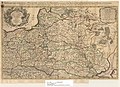
 Karte von Polen und den angränzenden Provinzen - Zusatz.jpg 2,623 × 3,623; 1.38 MB
-
 Karte von Polen und den angränzenden Provinzen 01.jpg 5,572 × 4,568; 7.27 MB
-
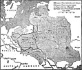 Kingdom of Poland.jpg 1,757 × 1,499; 494 KB
-
 Lithuanian (1850).jpg 1,386 × 1,021; 962 KB
-
 Livonia Islande.jpg 945 × 710; 1.05 MB
-
 Polonia – Jean Palairet 1755. (White Russia, Red Russia, Moscovia Russia).jpg 1,500 × 1,297; 655 KB
-
 БСЭ1. Латвия.jpg 1,001 × 1,622; 959 KB


.jpg)


.jpg)

.jpg)
