Commons:Graphic Lab/Map workshop/Archive/2022
 | This is an archive of past discussions. Do not edit the contents of this page. If you wish to start a new discussion or revive an old one, please do so on the current talk page. |
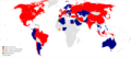
Metro in the World
-
 Description of first image
 -
Description of second image (if needed)
-
Description of third image (if needed; don't request too many at once, though)

Article(s): List of metro systems
- Request
- Please make Serbia orange as the Belgrade Metro is under construction and Iraq brown as the Baghdad Metro is being planned. --2603:8081:1602:E41F:15D:3469:BE01:D274 08:42, 18 January 2022 (UTC)
- Graphist opinion(s)
![]() Done – Uploaded your changes. Rcsprinter123 (talk) 20:35, 19 January 2022 (UTC)
Done – Uploaded your changes. Rcsprinter123 (talk) 20:35, 19 January 2022 (UTC)
Tagging for archiving, as the request seems to be fulfilled. --Donald Trung 『徵國單』 (No Fake News 💬) (WikiProject Numismatics 💴) (Articles 📚) 10:43, 29 January 2022 (UTC)
- This section was archived on a request by: Donald Trung 『徵國單』 (No Fake News 💬) (WikiProject Numismatics 💴) (Articles 📚) 10:43, 29 January 2022 (UTC)
map-request in illustration workshop
if anybody could help for this request in illustration workshop: COM:GL/I#Rail_transport_map_of_Turkey_maps
--Mrmw (talk) 10:37, 16 January 2022 (UTC)
-
 File:Rail transport map of Turkey.png
 -
 File:Rail transport map of Turkey-m.png
 -
 File:Rail transport map of Turkey in Turkish.png
 -
 File:TCDD.svg
 -
 File:Tcdd network.png


Article(s): Numerous articles across Wikipedia, where these three files appear.
- Request
- The three maps above need to be updated, because the Konya-Karaman high speed rail line was opened on 8 January 2022. The short thick black double track railway lines just to the east and to the west of Istanbul need to be colored in red.
- The latter two maps are duplicates of the the first and original map, and all three maps are widely used in Wikipedia articles. None of the original uploaders of these maps are active in Wikimedia Commons.
- Here is a source and other maps from Wikimedia Commons for reference:
- --Multituberculata (talk) 15:49, 28 February 2022 (UTC)
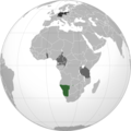
Central African Republic - Sudan Locator (orthographic projection).svg
-
 Bilateral map of the Central African Republic (sic) and Sudan
.svg)
- Request
- This map, created here, is wrong: the country shaded in green is South Sudan, not the Central African Republic. Can someone fix it? --Place Clichy 01:31, 12 March 2022 (UTC)
- @Sette-quattro: pinging creator. Place Clichy 13:09, 12 March 2022 (UTC)
- @Place Clichy whooops. corrected Sette-quattro (talk) 08:07, 16 March 2022 (UTC)
- @Sette-quattro:
 Thank you.! Place Clichy 08:37, 16 March 2022 (UTC)
- @Sette-quattro:
- @Place Clichy whooops. corrected Sette-quattro (talk) 08:07, 16 March 2022 (UTC)
- @Sette-quattro: pinging creator. Place Clichy 13:09, 12 March 2022 (UTC)
- Graphist opinion(s)
![]() Done by User:Sette-quattro here. Place Clichy 08:37, 16 March 2022 (UTC)
Done by User:Sette-quattro here. Place Clichy 08:37, 16 March 2022 (UTC)
- This section was archived on a request by: Place Clichy 08:37, 16 March 2022 (UTC)
NATO enlargement.svg

Article(s): many
- Request
- update
- According current news , Finland and Sweden need other colors. --Itu (talk) 16:50, 13 April 2022 (UTC)
- File:NATO affiliations in Europe.svg also exists, but as yet, neither should be changed until a formal decision to apply is made by either country, which I understand is still some time off, even if presumably inevitable in the short-term. GPinkerton (talk) 17:21, 13 April 2022 (UTC)
- Graphist opinion(s)
Now done by de-wiki --Itu (talk) 09:13, 5 May 2022 (UTC)
![]() Done
Done
Map of IKEA stores
-
 Description of first image
 -
Description of second image (if needed)
-
Description of third image (if needed; don't request too many at once, though)
Article(s): en:List of countries with IKEA stores
- Request
- Please add Puerto Rico in blue as IKEA is there and add Peru and Oman in yellow as they plan on opening IKEA stores.--2603:8081:1604:88DE:F402:4466:D101:EA4D 07:06, 3 December 2021 (UTC)
- Graphist opinion(s)
Alaska changes to Usa counties large
-
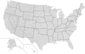 Usa counties large.svg
 -
 Alaska boroughs and census areas 2019.svg


Article(s): en:Wikipedia:WikiProject National Register of Historic Places/Progress and other places that have maps derived from this one
- Request
- Update Usa counties large.svg to reflect recent changes in Alaskan subdivisions
- There have been changes to Alaska's subdivisions, the latest apparently in 2019 when Chugash and Copper River Census Areas were created out of the Valdez-Cordova Census area. There may be other older changes in Alaska not reflected in the current version of Usa counties large -- can the file be updated to reflect the state subdivisions depicted in File:Alaska boroughs and census areas 2019.svg, please? I plan to fold the resulting SVG changes into other maps. --Magic♪piano 16:13, 7 January 2022 (UTC)
- Graphist opinion(s)
-
Description of first image
-
Description of second image (if needed)
-
Description of third image (if needed; don't request too many at once, though)
Article(s): [[]]
- Request
- Details of your request go here… --Aaronthegreat1989 (talk) 07:51, 13 January 2022 (UTC)
- Graphist opinion(s)
-
 Distribution of the Nilotic languages

- Request
- Please fix the colors on the map so that it is readable by people with red/green colorblindness, preferably by replacing the green with light gray. Please also add the boundary between Sudan and South Sudan, which is especially relevant on this map since the Nilotic languages are widespread in South Sudan but barely present in Sudan. Ideally, since it's a map, this PNG file should be replaced with an SVG file. Thanks! —Mahāgaja · talk 10:17, 13 January 2022 (UTC)
- Pinging @Davius: as the original creator of the map, although (s)he hasn't been around in several months. —Mahāgaja · talk 16:05, 13 January 2022 (UTC)
- Graphist opinion(s)
- @Mahagaja I've changed the colour scheme and added the border, as requested. I can try making an SVG map later, though as this has a different projection than that off most standardised maps, it may take some time. — Berrely • T∕C 20:08, 13 January 2022 (UTC)
- @Berrely: . Looks great, thank you! —Mahāgaja · talk 21:46, 13 January 2022 (UTC)
Commonwealth republics map - Gabon and Togo

Article(s): Any article this already appears on.
- Request
- Could someone please alter the above map of the republics within the Commonwealth of Nations so that Gabon and Togo are shaded red, as they joined the Commonwealth as republics on 25 June this year. Thanks. Snow Lion Fenian (talk) 16:54, 1 July 2022 (UTC)
- Graphist opinion(s)
@Snow Lion Fenian: ![]() Done M.Bitton (talk) 22:09, 18 July 2022 (UTC)
Done M.Bitton (talk) 22:09, 18 July 2022 (UTC)
- @M.Bitton: That's great, thanks for helping out. Snow Lion Fenian (talk) 22:18, 18 July 2022 (UTC)
Topographic map with contours highlighted
Article(s): en:Lake Estancia
- Request
- Is it possible to get a topographic map of the en:Lake Estancia basin with the 1897m ("late Estancia"), 1939m ("early Estancia") and 1870m ("Lake Willard") elevation contours highlighted and labelled? --Jo-Jo Eumerus (talk) 15:52, 22 January 2022 (UTC)
- Graphist opinion(s)
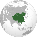
South Sudan borders required in orthographic maps
-
 File:Russian Federation (orthographic projection).svg
 -
 File:Rossija globus.png
 -
 File:Kashmir (orthographic projection).jpg should be like File:Kashmir (orthographic projection).svg and the green dot in the JPG map needs to be removed
 -
 File:German east africa map.png
 -
 File:German sw africa map.png
 -
File:German east africa map.png
-
 File:Vietnam (orthographic projection).svg where the border of South Sudan is very inaccurate, in other words, wrong
 -
 File:Iraq (orthographic projection).svg
 -
 File:Cyprus (orthographic projection).png
 -
 File:East Asian Cultural Sphere - Updated.png
 -
 File:East Asian Cultural Sphere - Sinocentist.png
 -
 File:Empire of the Great Qing (orthographic projection).svg
 -
 File:Greater Mongolia (orthographic projection).png
.svg)

.jpg)


.svg)
.svg)
.png)


.svg)
.png)
Article(s): Numerous articles across Wikipedia.
- Request
- The borders of South Sudan need to be added in these orthographic maps. --Maphobbyist (talk) 14:14, 4 February 2022 (UTC)
- Graphist opinion(s)
New
<galleryا8 >
IMAGE1.EXT| Description of first image
5ليﻷمهههههخ IMAGE3.EXT| Description of third image (if needed; don't request too many at once, though) </gallery>د for audio files: -->
Article(s): [[]]
- Request
- Details of your request go here… --105.101.183.99 14:46, 27 February 2022 (UTC)
- Graphist opinion(s)
1220-1 campaigns of Jalal al-Din
-
The movements of Khwarazmian prince Jalal al-Din in 1220 during the Mongol invasion
-
 English translation for this would be useful.

Article(s): en:Mongol conquest of the Khwarazmian Empire, en:Jalal al-Din Mangburni,
- Request
- A map showing the movements of Khwarazmian prince Jalal al-Din in 1220-1 during the Mongol invasion: those during his flight with his father from Fergana to the Caspian Sea, and those after his father's death until the en:Battle of the Indus.
- Similar to that found at [1] p.159, but also including his movements before the death of en:Muhammad II of Khwarazm as described in [2] p282-9. I can provide additional sources if needed.
- Many thanks in advance, ~~ AirshipJungleman29 (talk) 15:46, 21 February 2022 (UTC)
- Alternately, a translation of image 2 into English would also be helpful. ~~ AirshipJungleman29 (talk) 21:45, 2 March 2022 (UTC)
- Graphist opinion(s)
File:US and Russian bases and facilities.jpg
-
 File:US and Russian bases and facilities.jpg

Article(s): Numerous articles across Wikipedia.
- Request
- In File:US and Russian bases and facilities.jpg:
- Azerbaijan needs to be colored in white, because Azerbaijan never hosted a US military base, nor does it host a Russian base.
- Georgia needs to be colored in blue (like Belarus, Moldova and Armenia), because Georgia never hosted a US military base. It only has Russian military bases in breakaway Abkhazia and South Ossetia.
- The border of South Sudan, which became independent in 2011, needs to be added. Both South Sudan and Sudan do not host any US or Russian military bases, so their color stays unchanged. --Multituberculata (talk) 05:36, 4 March 2022 (UTC)
- Graphist opinion(s)
Wrong borders
-
 First French Empire before the french invasion of Russia on World 1812.
 -
 Colonial empires in 1812
 -
 Colonisation 1754
 -
 Colonial empires in 1800
 -
 Colonial empires in 1822


Article(s): Various
- Request
- The creator of the first two maps (First French Empire and Colonial empires in 1812) conflated 1812 with 1912 and added Morocco as a satellite state of the First French empire in 1812 which is totally unhistocal. Morocco was made a protectorate of France in 1912
- The three other maps (Colonisation 1754, Colonial empires in 1800 and Colonial empires in 1822) are also unhistorical maps. The northern part of Morocco was made a protectorate of Spain in 1912 and Western Sahara was made a Spanish colony in 1884.
- Can someone remove Morocco and western Sahara from these maps? --197.153.44.161 00:24, 17 March 2022 (UTC)
- Graphist opinion(s)
![]() Request taken by M.Bitton (talk) 00:38, 17 March 2022 (UTC)
Request taken by M.Bitton (talk) 00:38, 17 March 2022 (UTC)
- I suppose that by "remove", you mean remove the green colour from the first two and the yellow colour from the other three, while using the first as a base map. Let me know if I got it wrong. M.Bitton (talk) 00:38, 17 March 2022 (UTC)
- Remove the light green color from the first two maps and remove the yellow color from the three other ones. Leave the borders of the three maps as they are, in "Colonisation 1754" and in "Colonial empires in 1822" they are present-day borders, while in "Colonial empires in 1822" there are no borders. Thank you.197.153.44.161 00:58, 17 March 2022 (UTC)
- The present day borders in those maps are there to show the difference between then and now, I will leave them as they are and adjust the "1754" and "1822" maps using the first two as a base map. M.Bitton (talk) 01:04, 17 March 2022 (UTC)
- You will remove the present-day borders from the two maps (1754 and 1822)?197.153.44.161 01:10, 17 March 2022 (UTC)
- No, but I will adjust Morocco's map accordingly (in line with the others). M.Bitton (talk) 01:12, 17 March 2022 (UTC)
- But the maps are about Colonial powers, Morocco wasn't a colonial power or even a power. Are you going to add Morocco as a map symbol with its color?197.153.44.161 01:17, 17 March 2022 (UTC)
- True, but the same logic applies to the United States and the Ottoman empire (both shown as colonial powers). I expect the average reader to be familiar with the history of the former, so I won't delve into it, as for the latter (described as Turkey in two of the maps): even if we agree with the sources that say that it emerged as such during the late nineteenth century (second half of the nineteenth century at the earliest), these maps (depicting an earlier period) would still be incorrect. Here's what I'll do:
- First map: this is the easiest of the lot as all it needs is the removal of the green colour from Morocco. Although that doesn't make it perfect, since the Barbary States (which were at war with each other) are portrayed as a single country, it would still be a big improvement.
- The other maps: remove the green, yellow and dark grey colours from Morocco, Western Sahara, the United States and the Ottoman empire. For the "Colonial empires in 1800.svg", I will merge them with the rest of the continents (like the other countries that are not shown).
- Please note that overwriting files always comes with the risk of being reverted. Should that happen (though I doubt it in this case), the new maps will have to be uploaded under new names. M.Bitton (talk) 19:27, 17 March 2022 (UTC)
- True, but the same logic applies to the United States and the Ottoman empire (both shown as colonial powers). I expect the average reader to be familiar with the history of the former, so I won't delve into it, as for the latter (described as Turkey in two of the maps): even if we agree with the sources that say that it emerged as such during the late nineteenth century (second half of the nineteenth century at the earliest), these maps (depicting an earlier period) would still be incorrect. Here's what I'll do:
- But the maps are about Colonial powers, Morocco wasn't a colonial power or even a power. Are you going to add Morocco as a map symbol with its color?197.153.44.161 01:17, 17 March 2022 (UTC)
- No, but I will adjust Morocco's map accordingly (in line with the others). M.Bitton (talk) 01:12, 17 March 2022 (UTC)
- You will remove the present-day borders from the two maps (1754 and 1822)?197.153.44.161 01:10, 17 March 2022 (UTC)
- The present day borders in those maps are there to show the difference between then and now, I will leave them as they are and adjust the "1754" and "1822" maps using the first two as a base map. M.Bitton (talk) 01:04, 17 March 2022 (UTC)
- Remove the light green color from the first two maps and remove the yellow color from the three other ones. Leave the borders of the three maps as they are, in "Colonisation 1754" and in "Colonial empires in 1822" they are present-day borders, while in "Colonial empires in 1822" there are no borders. Thank you.197.153.44.161 00:58, 17 March 2022 (UTC)
Survey: Help improve Kartographer
Sorry for cross-posting
Do you create interactive maps with Kartographer (mapframe)? If your answer is yes, we would like to hear from you. Please take part in our survey and help improve Kartographer! Where do you run into problems using it? Which new features would you like to see? Editors of all experience levels and with all workflows around Kartographer are welcome to participate.
Here is the survey: https://wikimedia.sslsurvey.de/Kartographer-Workflows-EN/
- The survey is open until March 31.
- It takes 10-15 minutes to complete.
- The survey is anonymous. You don't need to register, and we will not store any personal data which identifies you, such as your name or IP address.
Unfortunately, the survey is only available in English, but we have tried our best to use simple English and to add visual examples. If English is not your native language, it might help to use a translation tool in your browser.
Some background: Wikimedia Germany's Technical Wishes team is currently working on the Kartographer extension. Over the last few months, we have been working on a solution to make this software usable on wikis where it isn’t available yet. In the next phase of the project, we are planning to improve Kartographer itself. Because Kartographer is used quite a lot on this wiki, we would love to hear about your experiences. More information on our work with Kartographer and the focus area of Geoinformation can be found on our project page.
Thank you for your help! – Johanna Strodt (WMDE) (talk) 09:44, 21 March 2022 (UTC)
Taiping Heavenly Kingdom map
-
 Map of the Taiping Heavenly Kingdom, 1854
 -

.png)

Article(s): en:Taiping Heavenly Kingdom, en:Taiping Rebellion. Could be used as basis for countless other Wikipedia pages in other languages. A Portuguese captions version would be done by me, so also pt:Reino Celestial Taiping and pt:Rebelião Taiping.
- Request
- Is this map too low quality to be turned into a SVG? I found the map used as reference but I think it was supposed to be colored. Since the text of the file is in French I will give a general translation so a SVG file could have English captions: "Territory controlled by Taiping in 1854", "Caption: • Taiping Heavenly Kingdom; • Guangxi, place of origin of the rebellion and later abandoned; • Nanjing, capital of Taiping under the name of Tianjing; • Chinese borders in 1820; • Current Chinese borders (those 2 last captions are unnecessary imo)", "Source: Thomas A. Reilly (...)". It would also be good if it's slighty changed for a more pleasing appearance, since this map looks like it was made using Paint. The map was originally uploaded in 2008 (File:Taiping2.PNG) but it had its accuracy disputed and that one is the fixed one. AnAkemie (talk) 10:54, 12 September 2022 (UTC)
- Graphist opinion(s)
- @AnAkemie: I uploaded a map that is based on the provided source. Unfortunately, I'm not really sure which area they are referring to with regard to the extent of control in 1854 (possibly Wenzhou and Shanghai). Please have a look and let me know what you think. M.Bitton (talk) 19:43, 12 September 2022 (UTC)
- @M.Bitton: That's a great map! I think it would be good to add some other important cities to the map but I will need to reread the article on Taiping Rebellion as reference. I think I can use your map as a map of the fall of the Taiping Heavenly Kingdom. The 1854 is the greatest extention so it would be great to also have it but unfortunately the map is black and white. AnAkemie (talk) 21:39, 12 September 2022 (UTC)
- @M.Bitton: I found this version where you can barely see the lines of the territory in 1854. It was really a problem during digitalization of the book. I hope this one works for you. There's a magnifying glass with a + symbol on there if you need to zoom. AnAkemie (talk) 00:33, 13 September 2022 (UTC)
- Can you basically include all cities that are inside Taiping territory on this map? Because pretty much all of them are necessary in some way. Please put these cities in both maps.
- There are some major cities near Taiping but I don't think it is necessary to put them, like Yangzhou, Zhenjiang and Wenzhou. An exception is Shanghai, because it was an extremely important city that was besieged multiple times by the Taiping and they failed capturing it.
- Beijing is important because it is the Qing capital and the Taiping tried to attack it.
- Tianjing is special because it is the Taiping capital.
- I also think the region of Guangxi should have some special marking on it just in the 1854 map, because that's where the rebellion started, even though the Taiping moved to other places.
- Another request is that you move File:Taiping Heavenly Kingdom map.svg to File:Taiping Heavenly Kingdom map (1862).svg since the current name is a bit misleading because it is the Taiping Heavenly Kingdom on its worst situation. Sorry for the many requests and thank you! AnAkemie (talk) 05:08, 13 September 2022 (UTC)
- @AnAkemie: The second map is much clearer. I'm not really sure what you mean by both maps as I don't intend on creating more than one (similar to one in the cited source). How about moving it to "File:Taiping Heavenly Kingdom map (1854-1862).svg"? M.Bitton (talk) 12:17, 13 September 2022 (UTC)
- @M.Bitton: Nevermind, the map is just too confusing. I think I will just e-mail the Washington Press University asking for clarification. I still think you should rename the file with the 1862 date as it is the Taiping at one of its final days and don't really represent how big the rebel state was. AnAkemie (talk) 17:18, 13 September 2022 (UTC)
- @AnAkemie: I found a much better map that highlights the Kingdom's different periods as well as the areas that it occupied (part of Guangxi included). It's slightly more complicated than the other, so will take longer to finish. Once finished, I will overwrite the current one and then we'll decide if a second one is worth having. M.Bitton (talk) 17:46, 13 September 2022 (UTC)
- @M.Bitton: Amazing! The map on the book was just too confusing. I think the 1854 and 1862 were supposed to be 2 totally different territories. Even the uploader on Wikimedia confused and unified the two on their 1854 map. For example, Ningbo was captured in 1861. AnAkemie (talk) 17:54, 13 September 2022 (UTC)
- @AnAkemie: Yes, the uploader combined both, even though the source makes it clear that they are separate periods (the original map that I was working on would of had different colours for them; that's why I didn't see the need to have two maps). M.Bitton (talk) 18:02, 13 September 2022 (UTC)
- @M.Bitton: That will be amazing. The Taiping Rebellion is such a massive event to have a wrong map like this. The thing literally killed more than WW1. AnAkemie (talk) 18:12, 13 September 2022 (UTC)
- @AnAkemie: I updated the map using the new source and added the most important cities. Please have a look and let me know what you think. M.Bitton (talk) 14:21, 15 September 2022 (UTC)
- @M.Bitton: I think you should add Nanjing to the map as "Tianjing (Nanjing)", with some marking because it was the Taiping capital. And Shanghai and Wenzhou now look like they are inside Taiping territory, which they weren't. Apart from that, it's a map 100 times better than the other. AnAkemie (talk) 17:41, 15 September 2022 (UTC)
- @AnAkemie:
 Done I added "Nanjing" only as there isn't enough room to have both names ("Tianjing (Nanjing)"). M.Bitton (talk) 13:19, 16 September 2022 (UTC)
- @M.Bitton: Fair enough. Just a question before I mark the request as done: These areas marked as "Taiping occupied" were occupied in different times, right? AnAkemie (talk) 15:14, 16 September 2022 (UTC)
- @AnAkemie: That's right. They represent the areas that were occupied for a brief period (either during their various expeditions or while making their last stand). While the used source doesn't mention this, there are others that do. M.Bitton (talk) 16:21, 16 September 2022 (UTC)
- @M.Bitton: Got it. Thank you so much for your work and patience! AnAkemie (talk) 16:40, 16 September 2022 (UTC)
- You're welcome. M.Bitton (talk) 23:32, 16 September 2022 (UTC)
- @M.Bitton: Got it. Thank you so much for your work and patience! AnAkemie (talk) 16:40, 16 September 2022 (UTC)
- @AnAkemie: That's right. They represent the areas that were occupied for a brief period (either during their various expeditions or while making their last stand). While the used source doesn't mention this, there are others that do. M.Bitton (talk) 16:21, 16 September 2022 (UTC)
- @M.Bitton: Fair enough. Just a question before I mark the request as done: These areas marked as "Taiping occupied" were occupied in different times, right? AnAkemie (talk) 15:14, 16 September 2022 (UTC)
- @AnAkemie:
- @M.Bitton: I think you should add Nanjing to the map as "Tianjing (Nanjing)", with some marking because it was the Taiping capital. And Shanghai and Wenzhou now look like they are inside Taiping territory, which they weren't. Apart from that, it's a map 100 times better than the other. AnAkemie (talk) 17:41, 15 September 2022 (UTC)
- @AnAkemie: I updated the map using the new source and added the most important cities. Please have a look and let me know what you think. M.Bitton (talk) 14:21, 15 September 2022 (UTC)
- @M.Bitton: That will be amazing. The Taiping Rebellion is such a massive event to have a wrong map like this. The thing literally killed more than WW1. AnAkemie (talk) 18:12, 13 September 2022 (UTC)
- @AnAkemie: Yes, the uploader combined both, even though the source makes it clear that they are separate periods (the original map that I was working on would of had different colours for them; that's why I didn't see the need to have two maps). M.Bitton (talk) 18:02, 13 September 2022 (UTC)
- @M.Bitton: Amazing! The map on the book was just too confusing. I think the 1854 and 1862 were supposed to be 2 totally different territories. Even the uploader on Wikimedia confused and unified the two on their 1854 map. For example, Ningbo was captured in 1861. AnAkemie (talk) 17:54, 13 September 2022 (UTC)
- @AnAkemie: I found a much better map that highlights the Kingdom's different periods as well as the areas that it occupied (part of Guangxi included). It's slightly more complicated than the other, so will take longer to finish. Once finished, I will overwrite the current one and then we'll decide if a second one is worth having. M.Bitton (talk) 17:46, 13 September 2022 (UTC)
- @M.Bitton: Nevermind, the map is just too confusing. I think I will just e-mail the Washington Press University asking for clarification. I still think you should rename the file with the 1862 date as it is the Taiping at one of its final days and don't really represent how big the rebel state was. AnAkemie (talk) 17:18, 13 September 2022 (UTC)
- @AnAkemie: The second map is much clearer. I'm not really sure what you mean by both maps as I don't intend on creating more than one (similar to one in the cited source). How about moving it to "File:Taiping Heavenly Kingdom map (1854-1862).svg"? M.Bitton (talk) 12:17, 13 September 2022 (UTC)
- @M.Bitton: I found this version where you can barely see the lines of the territory in 1854. It was really a problem during digitalization of the book. I hope this one works for you. There's a magnifying glass with a + symbol on there if you need to zoom. AnAkemie (talk) 00:33, 13 September 2022 (UTC)
1840 map of the Holy Land / Palestine (modern Israel)
-
 My amateur version of the combined map
 -
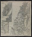 Original file (north)
 -
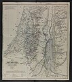 Original file (south)
.jpg)


Article(s): History of Palestine (as new lead image, replacing existing) and Cartography of Palestine and Ottoman Syria and Biblical Researches in Palestine. Also extracted versions at Acre Sanjak, Nablus Sanjak, Jerusalem Sanjak etc
- Request
- Create an improved version of the 1841 Kiepert map of Palestine
This map is a milestone in the history of maps of the Holy Land. A large part of this recent book is dedicated to it: Schelhaas, B. (2017) Mapping the Holy Land: The Foundation of a Scientific Cartography of Palestine, Bloomsbury Publishing ISBN: 978-0-85772-785-5. The map was the key illustration in the foundational book of the study of the Holy Land: Biblical Researches in Palestine by Edward Robinson (scholar); on p.16 of the book just linked they quote: "Perhaps, Robinson’s most important accomplishment, however, was the drawing of new maps of the whole region. For this purpose he hired a young German map maker, Heinrich Kiepert… Through his efforts the maps of ancient Israel were thoroughly revised and improved; modern cartography of the Holy Land begun."
In additional to Biblical Geography, the maps also are the first which show the detailed subdivisions of contemporary Palestine. The maps currently in the lede of en:History of Palestine will have been copied (with minor adjustments) from this map.
I would like this map to be widely used throughout Wikipedia. Before I start linking it and creating extract files, I wanted to ask if anyone here would be willing to improve it (the file currently linked above is my amateur attempt at creating a combined file and making the colors more vivid). It could also become a Featured Picture. Perhaps the most important improvement it needs is to remove the yellow background whilst maintaining the rest of the coloring. --Onceinawhile (talk) 15:08, 23 March 2022 (UTC)
- Graphist opinion(s)
![]() Done
Well, Onceinawhile, at least a first attempt, please check for mistakes. (Refresh to get new version.) Zero0000 (talk) 13:49, 31 March 2022 (UTC)
Done
Well, Onceinawhile, at least a first attempt, please check for mistakes. (Refresh to get new version.) Zero0000 (talk) 13:49, 31 March 2022 (UTC)
- Hi Zero0000! Thank you. Yours is a big improvement, both in resolution and in color.
- I had a close up look at some of the subdivision lines and the colors look a bit odd in places on my screen. For example the horizontal line east of Sidon and the vertical line between Sidon and Beirut, look multi-colored, and the thin boundary lines of Mount Lebanon and the area around Tripoli (some bluish and some greenish) are quite hard to see. Ideally the boundary colors would be as vivid and clear as on the map File:Modern Palestine, Illustrated atlas, and modern history of the World, 1851.jpg, but I have no idea how to do that in an efficient manner. Onceinawhile (talk) 14:28, 31 March 2022 (UTC)
- Onceinawhile, apart from a few lines in one of the cutouts at top left that are almost invisible in the original, I just enhanced the colored lines by saturating them. So variations in color along the same line are present in the originals, and the width of the lines is exactly what is in the originals. I can reduce the colour variation without too much effort, but making it look similar to the 1851 map would required manually drawing new lines that are wider (more than twice in many cases) than the originals. I'm not sure that is a valid objective; it feels like illicit image manipulation. Zero0000 (talk) 02:09, 1 April 2022 (UTC)
- I don't understand your comment about the lines around Tripoli. There are no greenish lines (except the one around the city) and they are perfectly visible at full resolution. Zero0000 (talk) 02:31, 1 April 2022 (UTC)
- Sorry I didn’t mean Tripoli, I meant Beirut in the main map – both the area to the northeast and to the southeast. In my original attempt, I fiddled with the image parameters so much that these colors became clear to see on the main map; unfortunately the yellow map background became much too strong at the same time. Onceinawhile (talk) 05:23, 1 April 2022 (UTC)
- I can go over the lines with more intense versions of the same colors, without making the lines wider. That would make them more uniform and visible, but only the thicker lines will stand out at lower resolution. It isn't really true to the original map and that bothers me. Do we want to display the map, or just the information in the map? Zero0000 (talk) 03:17, 1 April 2022 (UTC)
- Hi Zero0000 my thinking is that originally the base map would have been pure white (it is the lignin in the paper which yellows with age) so the colored boundary lines would have much more vivid. Onceinawhile (talk) 05:19, 1 April 2022 (UTC)
- It would have been some off-white color. Pure white paper was only a few decades old and expensive. But, sure, it would have been whiter than these images. The basic reason why increasing the saturation of the lines didn't work well is that the non-uniform discoloration of the paper includes the colored bits so they are nonuniform too. I'm trying a different method that gives uniform color and I can make the whole thing brighter. But the finest lines are still very thin and that limits the visibility no matter what the colors are. I really don't want to make them thicker. The original paper map was at full resolution all the time. Incidentally it is a waste of time to play with overall color mapping, there is too much overlap between the yellowing of the paper and the colors in the lines. Zero0000 (talk) 06:52, 1 April 2022 (UTC)
- This makes complete sense to me, agree with everything you said. Onceinawhile (talk) 09:07, 1 April 2022 (UTC)
- OK, I have a system now. A bit laborious but gives ok results. Zero0000 (talk) 08:00, 1 April 2022 (UTC)
- I don't know what you are doing but it sounds like magic! Onceinawhile (talk) 09:07, 1 April 2022 (UTC)
- Onceinawhile, hard work more like it. Second attempt uploaded. Two things: I replaced one or two colors that were indistinguishable in their faded original state; Sometimes the colored highlights deviate significantly from the boundary (which appears on the map as a dashed line), in which case I followed the highlights. Zero0000 (talk) 13:33, 1 April 2022 (UTC)
- Hi @Zero0000: that is wonderful. It looks excellent. I have gone through and compared it to the original and I can't see anything missing (perhaps with the exception of the little ring around Beirut?). Thank you so much. After all that work I thought you might enjoy reading Herr Kiepert's explanation of his work:[3] 11. Division into Provinces and Districts. This has been done, by way of trial, from the Lists of Arabic names of places collected by Mr. Smith, and found in the Second Appendix to the present volume. Very often, however, the exact boundaries remained doubtful; partly because many known places do not occur in the lists; and partly because of several districts there yet exist no lists at all; e. g. Yafa, Haifa, Belâd Besharah, Belâd esh-Shủkif, etc. The boundaries of the subdivisions, in particular, were difficult to be determined accurately; and they are consequently for the most part omitted. Nevertheless, even this approximation to a more exact division, will afford a more definite and correct view, than has been the case with the attempts in all former maps, founded as they were on far more imperfect data.
- Are you happy for me to use it to the various proposed pages now? Onceinawhile (talk) 14:16, 1 April 2022 (UTC)
- I brightened Beirut, softened the edges of the coloured highlights a tiny bit, and did some inconsequential tweaking. I'm happy for it to go into production now. Zero0000 (talk) 02:02, 2 April 2022 (UTC)
- Thank you Zero. Before extracting pieces I have started writing an article on the topic - see Kiepert maps of Palestine and Jerusalem. Onceinawhile (talk) 07:26, 2 April 2022 (UTC)
- I brightened Beirut, softened the edges of the coloured highlights a tiny bit, and did some inconsequential tweaking. I'm happy for it to go into production now. Zero0000 (talk) 02:02, 2 April 2022 (UTC)
- Onceinawhile, hard work more like it. Second attempt uploaded. Two things: I replaced one or two colors that were indistinguishable in their faded original state; Sometimes the colored highlights deviate significantly from the boundary (which appears on the map as a dashed line), in which case I followed the highlights. Zero0000 (talk) 13:33, 1 April 2022 (UTC)
- I don't know what you are doing but it sounds like magic! Onceinawhile (talk) 09:07, 1 April 2022 (UTC)
- It would have been some off-white color. Pure white paper was only a few decades old and expensive. But, sure, it would have been whiter than these images. The basic reason why increasing the saturation of the lines didn't work well is that the non-uniform discoloration of the paper includes the colored bits so they are nonuniform too. I'm trying a different method that gives uniform color and I can make the whole thing brighter. But the finest lines are still very thin and that limits the visibility no matter what the colors are. I really don't want to make them thicker. The original paper map was at full resolution all the time. Incidentally it is a waste of time to play with overall color mapping, there is too much overlap between the yellowing of the paper and the colors in the lines. Zero0000 (talk) 06:52, 1 April 2022 (UTC)
- Hi Zero0000 my thinking is that originally the base map would have been pure white (it is the lignin in the paper which yellows with age) so the colored boundary lines would have much more vivid. Onceinawhile (talk) 05:19, 1 April 2022 (UTC)
Stockholm
-
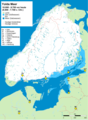 Yolda_MeerX
 -
 Baltischer_EisstauseeX


Article(s): Used in various articles.
- Request
- Could you please fix the dot for St (Stockholm) on the two maps. Map1: dot size like in map2. Map2: dot position like in map1.--Pp.paul.4 (talk) 11:23, 5 September 2022 (UTC)
- Graphist opinion(s)
![]() Request taken by --please ping me-- Goran tek-en (talk) 10:33, 28 September 2022 (UTC)
Request taken by --please ping me-- Goran tek-en (talk) 10:33, 28 September 2022 (UTC)
Pp.paul.4 Check those drafts, feedback thanks. --please ping me-- Goran tek-en (talk) 15:25, 27 September 2022 (UTC)
- Yolda draft
- Baltischer draft --please ping me-- Goran tek-en (talk) 15:25, 27 September 2022 (UTC)
Goran tek-en Well done. That's what I meant. --Pp.paul.4 (talk) 08:23, 28 September 2022 (UTC)
- Pp.paul.4
- New versions uploaded.
- If you are happy with this please put the code
"{{section re.solved|1=~~~~}}"(without the ".") on this request so it can be archived, thanks. Done --please ping me-- Goran tek-en (talk) 10:33, 28 September 2022 (UTC)
- Goran tek-en
1992 Summer Olympics medal map.png
-
 Participating nations during the 1992 Summer Olympics
 -
 2020 Summer Olympics medal map


Article(s): en:1992 Summer Olympics medal table
- Request
- I would like a colored map to be created showing medal results for each nation during the 1992 Summer Olympic using the 1992 Summer Olympics participating countries map in the first image. The first image is also a reference guide to the nations that did participates in the 1992 Summer Olympics. I also posted an example from the 2020 Summer Olympics showing medals results with countries in gold (for nations that won at least one gold medal), silver (nations that won at least one silver medal, but no gold medals), bronze (nations that ONLY won at least one bronze medal), blue (nations that won zero medals), and red (nations that did not participate in that year's Olympics) --Birdienest81 (talk) 13:34, 6 April 2022 (UTC)
- Graphist opinion(s)
Map of the French protectorates of Annam and Tonkin in 1937
Overview of the request
-
 A map of the first (1st) and second (2nd) level subdivisions of French Indo-China in the Gregorian year 1937.
 -
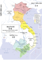 Map of the Nguyễn Dynasty in 1838.
 -
 Additional map of French Indo-China, for reference.
 -
 Concept image of the map I want to have created.
 -
 Concept of how the names would look like, though the purple areas shouldn't show the provincial boundaries, only the boundaries of the federal components of French Indo-China.

.svg)


Article(s): en:Nguyễn dynasty
- Request
I would like to request the creation of a map of the provinces of the Nguyễn Dynasty in 1937 based on the above maps. The French protectorate of Tonkin should be red while the French protectorate of Annam yellow to reflect the map of the Nguyễn Dynasty under the Minh Mạng Emperor above, the rest of French Indochina should be a very light shade of purple (or as transparent as possible) to indicate that Đại-Nam is a part of the Union of Indo-China but clear enough that the observer will see that the rest of French Indo-China is not a part of Đại-Nam.
The best way to do this is by using the map and code of "File:Nguyen Dynasty, administrative divisions map (1838).svg" as the base, use the administrative boundaries and names of "File:French Indochina 1937.png", and then use the general layout and colour scheme of "File:Nguyễn Dynasty in 1937 concept map.png".
- Differences between French and Nguyễn names and notes.
Also note that the Nguyễn Dynasty maintained different names for several provinces than the French, for example "1e Territoire Militaire" should be called "Hải Ninh 海寧" and "2e Territoire Militaire" should be called "Cao Bằng 高平".
On Wikipedia I find that the Đắk Lắk Province was split before this "1931: it consisted of 5 provinces: Buôn Ma Thuột, Buôn Hồ, Đắk Song, Lak, M'Đrăk", but I can't find any other maps than the one I have of 1937. Likewise before 1950 Vĩnh Phúc (永福) was the provinces of Vĩnh Yên (永安) and Phúc Yên (福安), but I can't find that in the source map. I suppose that improvements can be made with better sources available as SVG files can constantly be improved. Additional sources can simply be added at the list of sources in the file description in the future, I know a WikiCartographer who was really knowledgeable about these things, but she retired, so I'm basing it now mostly on the 1937 map.
- Colours
Red = Xứ bảo hộ Bắc Kỳ - 處保護北圻
Yellow = Xứ bảo hộ Trung Kỳ - 處保護中圻
Purple (very light purple) = Phần còn lại của Đông Dương 份群賴𧵑東洋
- Text in the box
ĐẠI NAM QUỐC 大南國 Bảo Đại năm thứ 12 - 保大拾貳年 1937 - MCMXXXVII
File layout
- Publishing information
- File name = "File:Nguyễn Dynasty, administrative divisions map (1937).svg".
- File caption = A map of the administrative divisions of the Nguyễn Dynasty in the year 1937 (Bảo Đại 12) within French Indochina.
- File description = A map of the administrative divisions of the Nguyễn Dynasty in the year 1937 (Bảo Đại 12) within French Indochina.
- Xứ bảo hộ Bắc Kỳ - 處保護北圻 - Protectorat français du Tonkin
- Xứ bảo hộ Trung Kỳ - 處保護中圻 - Protectorat français d'Annam
Sources: "File:French Indochina 1937.png"
- License = Uploader's choice.
- Categories = "Category:Historical regions of the Nguyễn Dynasty" & "Category:Maps of French Indochina"
French Indo-China and foreign countries
- Other states of French Indo-China
- Laos = Xứ Bảo hộ Lào 處保護寮
- Cambodia = Xứ Bảo hộ Campuchia 處保護高棉
- French Cochinchina = Xứ thuộc địa Nam Kỳ 處屬地南圻
- Guangzhouwan = Lãnh thổ Quảng Châu Loan 領土廣州灣
- Foreign countries
- Republic of China = Trung Quốc 中國
- Kingdom of Thailand = Thái Lan 泰闌
- British Raj = Ấn Độ 印度
Provinces
Generally left-to-right, up-to-down. Based on the provinces found at: https://upload.wikimedia.org/wikipedia/commons/7/79/French_Indochina_1937.png
Capital cities in bold.
French Protectorate of Tonkin
- 4e Territoire Militaire = Lai Châu 萊州
- Lao Kay = Lào Cai 老街
- 3e Territoire Militaire = Hà Giang 河楊
- 2e Territoire Militaire = Cao Bằng 高平
- Yen Bay = Yên Bái 安沛
- Tuyen Quang = Tuyên Quang 宣光
- Bac Kan = Bắc Kạn 北𣴓
- Lang Son = Lạng Sơn 諒山
- Thai Nguyen = Thái Nguyên 太原
- Son La = Sơn La 山羅
- Phu Tuo = Phú Thọ 富壽
- Vinh Yen = Vĩnh Yên 永安
- Bac Giang = Bắc Giang 北江
- 1e Territoire Militaire = Hải Ninh 海寧
- Son Tay = Sơn Tây 山西
- Hadong = Hà Đông 河東
- Hanoi = Hà Nội 河內
- Bac Ninh = Bắc Ninh 北寧
- Hai Duong = Hải Dương 海陽
- Kien An = Kiến An 建安
- Quang Yen = Quảng Yên 廣安
- Hoa Binh = Hòa Bình 和平
- Hung Yen = Hưng Yên 興安
- Ninh Binh = Ninh Bình 寧平
- Nam Dinh = Nam Định 南定
- Thai Binh = Thái Bình 太平
French Protectorate of Annam
- Thanh Hoa = Thanh Hóa 清化
- Vinh = Nghệ An 乂安
- Ha Tinh = Hà Tĩnh 河靜
- Dong Hoi = Quảng Bình 廣平
- Quang Tri = Quảng Trị 廣治
- Hué (province) = Thừa Thiên 承天
- Hué (ville) = Huế 化
- Tourane = Quảng Nam 廣南
- Kontum = Kon Tum 崑嵩
- Quang Ngai = Quảng Ngãi 廣義
- Quy Nhon = Bình Định 平定
- Plei Ku = Pleiku 坡離俱
- Song Cau = Phú Yên 富安
- Ban Me Thuot = Đắk Lắk 得勒
- Nha Trang = Nha Trang 芽莊
- Dalat = Đà Lạt 多樂
- Phan Rang = Ninh Thuận 寧順
- Phan Thiet = Bình Thuận 平順
French-administered cities
These should be marked with a yellow circle, while Huế a yellow square.
- Hanoi = Hà Nội 河內
- Haiphong = Hải Phòng 海防
- Da Nang = Đà Nẵng 沱㶞
Discussion
I hope that I've made the request clear enough to be easily taken. If you have any questions then please ping me. --Donald Trung 『徵國單』 (No Fake News 💬) (WikiProject Numismatics 💴) (Articles 📚) 10:48, 29 January 2022 (UTC)
 Addendum Also, the names of bodies of water 💧 (like rivers, seas, and gulfs) remain the same from the 1838 map. --Donald Trung 『徵國單』 (No Fake News 💬) (WikiProject Numismatics 💴) (Articles 📚) 10:54, 29 January 2022 (UTC)
- Note, the creator of the original map told me that she made it using Adobe Illustrator. I'm not versed enough in Adobe Illustrator to try and re-create a map of French Indo-China using the software which is why I've made an updated version of the concept map above. She also used a hand-drawn version of Traditional Chinese characters which I would recommend not emulating as the standardised Traditional Chinese characters you can write are useable here. --Donald Trung 『徵國單』 (No Fake News 💬) (WikiProject Numismatics 💴) (Articles 📚) 21:08, 16 April 2022 (UTC)
- I've attempted to made it without much success, namely in my version of Adobe Illustrator the lines seem to move around. There's no need to emulate the Traditional Chinese characters of the Minh Mạng map, using standard Traditional Chinese characters will probably look better too. --Donald Trung 『徵國單』 (No Fake News 💬) (WikiProject Numismatics 💴) (Articles 📚) 18:19, 29 May 2022 (UTC)
- Graphist opinion(s)
Donald Trung I hope I can help you, it's a lot of information here and I'm not sure that I exactly understand what you want and having so much text in a map is always difficult. If you are ready to support and help me in this work I will try to help you, let me know, thanks. --please ping me-- Goran tek-en (talk) 14:17, 27 September 2022 (UTC)
- @Goran tek-en: , I completely understand, there was a WikiGraphist who was already working on it but she accidentally deleted the drafts and after that she retired from the Wikimedia Commons altogether, I will try to help wherever possible. To make things as simple as possible, the requested file is essentially at the format of "File:Nguyen Dynasty, administrative divisions map (1838).svg" but with the borders of "File:French Indochina 1937.png" (only the provincial borders of blue and red'ish) and the colours and general layout of "File:Nguyễn Dynasty in 1937 concept map.png" and "File:Nguyễn Dynasty in 1937 concept map - Names.png".
- As you can see at "File:Nguyen Dynasty, administrative divisions map (1838).svg" the text is very small, essentially the map should be able to be zoomable, it's not really supposed to be a "first (1st) glance" map, it's a map that you should enlarge to appreciate, which is why the request is so detailed and why I've tried to get into as much details as possible. If you need any help I'm always just a ping away. --Donald Trung 『徵國單』 (No Fake News 💬) (WikiProject Numismatics 💴) (Articles 📚) 16:07, 27 September 2022 (UTC)
 Request taken by --please ping me-- Goran tek-en (talk) 16:51, 27 September 2022 (UTC)
- @Donald Trung So know I want to check with you regarding the base map and the borders, draft borders. --please ping me-- Goran tek-en (talk) 15:13, 28 September 2022 (UTC)
- @Goran tek-en: , almost, you are missing the borders of French Cochinchina found at the bottom here and the borders of Guangzhouwan found here. Both of which appear in detailed maps at the top of this request. --Donald Trung 『徵國單』 (No Fake News 💬) (WikiProject Numismatics 💴) (Articles 📚) 15:25, 28 September 2022 (UTC)
- @Donald Trung
- Nguyễn Dynasty in 1937 concept map also has a border between Cambodia and Laos, should it be included?
- The concept map (above) about what you want doesn't show any provincial boundaries but for the other concept map Nguyễn Dynasty in 1937 concept map - Names you write that you want them for the red and yellow areas, is this correct?
- --please ping me-- Goran tek-en (talk) 16:52, 29 September 2022 (UTC)
- @Donald Trung
- @Goran tek-en: , almost, you are missing the borders of French Cochinchina found at the bottom here and the borders of Guangzhouwan found here. Both of which appear in detailed maps at the top of this request. --Donald Trung 『徵國單』 (No Fake News 💬) (WikiProject Numismatics 💴) (Articles 📚) 15:25, 28 September 2022 (UTC)
.png)
- @Goran tek-en: , regarding (1), the way I envision it the rest of French Indo-China itself shows 1st (first) level subdivisions (the names of the other member countries of French Indo-China) and their boundaries, the Nguyễn Dynasty / Empire of Đại-Nam shows its two (2) countries in distinct colours and display 2nd (second) level administrative divisions (provinces). So the provinces of Laos, Cambodia, and Cochinchina are ignored and their name appears on where they are on the map, and for the Nguyễn Dynasty (Annam & Tonkin) the provinces are shown with their names in Latin script and Traditional Chinese characters.
- This way it shows that the Nguyễn Dynasty was two (2) members in a union of 5 (five) different countries but places the focus on the Empire of Đại-Nam while not excluding the rest of French Indo-China.
- (2) Basically this is a map of the provinces of the Nguyễn Dynasty within French Indo-China but not a map of the rest of the provinces of French Indo-China. I hope that I explained it as clear as possible. --Donald Trung 『徵國單』 (No Fake News 💬) (WikiProject Numismatics 💴) (Articles 📚) 18:08, 29 September 2022 (UTC)
- (2) Basically this is a map of the provinces of the Nguyễn Dynasty within French Indo-China but not a map of the rest of the provinces of French Indo-China. I hope that I explained it as clear as possible.
- @Donald Trung So check if this is correct so far, you really have to check the different islands. Draft AT-2 --please ping me-- Goran tek-en (talk) 16:17, 30 September 2022 (UTC)
- @Goran tek-en: , yes, exactly like that. My advice would be to use a "softer red" like in the 1836 map of the Nguyễn Dynasty to make the names of the provinces more visible but yes, this is exactly the base map that I want.
 I will turn it into a concept you could possibly adapt. --Donald Trung 『徵國單』 (No Fake News 💬) (WikiProject Numismatics 💴) (Articles 📚) 17:32, 30 September 2022 (UTC)
 - @Goran tek-en: , for reference I updated your concept map with the general layout for everything except for provincial names and then added it at the top of this request. I thought about making the capital of the country a yellow square and then the French concession cities as purple circles, this is because the French concession cities, while technically and legally a part of the territory of the Nguyễn Dynasty, were administratively under direct French control and could therefore be equally seen as "another part of French Indo-China", as the Emperor of the Nguyễn Dynasty could issue decrees that affected the laws surrounding these concession cities but the concession cities themselves were ruled by mayoral decrees issued by the respective (French) mayors of those cities. This is why I think that purple is a better choice for Hanoi, Haiphong, and Tourane. Of course, these circles should likely be made much smaller.
- @Goran tek-en: , yes, exactly like that. My advice would be to use a "softer red" like in the 1836 map of the Nguyễn Dynasty to make the names of the provinces more visible but yes, this is exactly the base map that I want.
- For smaller provinces I would suggest just following the layout made by user "A" / user "Lệ Xuân", she put a number and then listed it above the colour legend. I think that this is probably a complete request now and only the names of the provinces should be added. Of course, you're free to add the names with the placing and fonts you wish, as the images I added there is just a concept map on which you can exercise creative freedom. I specifically addeded the French concession cities there so you would know their location. --Donald Trung 『徵國單』 (No Fake News 💬) (WikiProject Numismatics 💴) (Articles 📚) 19:59, 30 September 2022 (UTC)
- Genius, I forgot to add the French names in the legend of the concept map, mainly the "Protectorat français du Tonkin" and "Protectorat français d'Annam" parts. Doh! --Donald Trung 『徵國單』 (No Fake News 💬) (WikiProject Numismatics 💴) (Articles 📚) 20:02, 30 September 2022 (UTC)
- @Donald Trung I made a mistake not to inform you clearly about those drafts:
- Those drafts are PNG versions of the original SVG file I'm working in and will upload to commons.
- Those drafts are shown for proofreading only.
- So because of this, SORRY but before I continue you have to delete the map you uploaded based on the draft I showed you. You have NO right to do anything with does draft, no usage and NOT uploading them to any wikimedia part.
- What you can do when needed is: download my drafts, add your information on them and then email them to me, nothing else.
- I do hope you respect and accept this.
- So get back to me when that last map is deleted from commons, thanks. --please ping me-- Goran tek-en (talk) 12:24, 1 October 2022 (UTC)
- @Goran tek-en: , excuse the late reply as I didn't get your ping, it might be wise to reply with "{{Reply|Donald Trung}}", though I got your pings earlier. Anyhow, I've tagged it for deletion and it should be off the Commonswiki soon.
How else am I supposed to communicate changes? Can I use Imgur or some other service to respond to concept maps by showing small changes?E-mail, alright. --Donald Trung 『徵國單』 (No Fake News 💬) (WikiProject Numismatics 💴) (Articles 📚) 12:15, 4 October 2022 (UTC)- Done, It removed "File:Nguyễn Dynasty concept map (Bảo Đại 12).png|Concept map based on the second (2nd) Google Drive file, I marked the site of the French concession cities for reference." and any version of the file. Excuse me for the inconvenience. --Donald Trung 『徵國單』 (No Fake News 💬) (WikiProject Numismatics 💴) (Articles 📚) 12:34, 4 October 2022 (UTC)
- @Donald Trung I use the reply app often and it gives the ping code automatically, lets see if it just was a one time thing, if not I will use other code.
- Thanks for understanding me, it's so easy a map get used before it's ready if it's uploaded to different places and then out of my/ours control and I like to be sure what is published in my name.
- Your request contains a lot of information which I have no knowledge of so I prefer to ask before I do to much work which has to be redone later on. In this draft it's just about to check so that this is the type of names you want for the Vietnamese language. The size and placing will be fine tuned later on.
- For the cities: We try to use Maps template-en as much as possible and in that template there are symbols for cities which I have put out for now, if you later on still want to change to what you have written we can discuss that then.
- There is some confusion from my side for which cities to put out and which is capitals or not and what is cities in your request, I understand it's all very clear for you but I don't have your knowledge. I have put out what I think but I can't find translations for Phnom Penh and Ho Chi Min City.
- So please check for those things in this draft
- --please ping me-- Goran tek-en (talk) 18:29, 4 October 2022 (UTC)
- Goran tek-en, I did get your ping this time. There are only 3 (three) cities in this request, capital cities of the rest of French Indo-China, like Ho Chi Minh City (then known as Saigon-Cholon) and Phnom Penh, are not needed.
On the draft that is now deleted I specifically specified where all the cities were and how to illustrate them. I hope that you saved it before it got deleted. -- — Donald Trung 『徵國單』 (No Fake News 💬) (WikiProject Numismatics 💴) (Articles 📚) 18:33, 4 October 2022 (UTC)- @Donald Trung OK I will do my best.
- No I didn't save it, don't you have it and can email me, or we just continue and work from there. --please ping me-- Goran tek-en (talk) 10:51, 5 October 2022 (UTC)
- Goran tek-en, Alright, I screenshotted it on my mobile telephone so I can retrieve it and e-mail it to you (as the original file is on my wife's laptop and she has a knack for "cleaning up" (read: deleting) files). Otherwise I can simply add the Wikipedia links to the cities here as a better frame of reference as they give more precise coordinates, I'll do that. -- — Donald Trung 『徵國單』 (No Fake News 💬) (WikiProject Numismatics 💴) (Articles 📚) 10:59, 5 October 2022 (UTC)
- Goran tek-en, I did get your ping this time. There are only 3 (three) cities in this request, capital cities of the rest of French Indo-China, like Ho Chi Minh City (then known as Saigon-Cholon) and Phnom Penh, are not needed.
- @Goran tek-en: , excuse the late reply as I didn't get your ping, it might be wise to reply with "{{Reply|Donald Trung}}", though I got your pings earlier. Anyhow, I've tagged it for deletion and it should be off the Commonswiki soon.
Discussion about the Nguyễn Dynasty under Bảo Đại map arbitrary break
The cities include:
Capital city. (Golden box)
French concession cities. (Purple circles)
--Donald Trung 『徵國單』 (No Fake News 💬) (WikiProject Numismatics 💴) (Articles 📚) 11:01, 5 October 2022 (UTC)
- @Goran tek-en: , here are all the cities. This way you can easily locate them, note that Hanoi was both a French concession city and the capital city of the French protectorate of Tonkin. For Hanoi I think that it could be a purple circle with a golden edge around it and for Haïphong and Tourane they could be purple circles with a black edge. No other cities have to be mentioned as it's a map of the first (1st) level administrative divisions of Đại Nam Quốc and not its major cities. --Donald Trung 『徵國單』 (No Fake News 💬) (WikiProject Numismatics 💴) (Articles 📚) 11:08, 5 October 2022 (UTC)
- @Donald Trung
- In this draft I have used the symbols for cities we have in in our Map Template. If you later on absolutely want the ones you described you can of course have them but I can't really see how not using our templates symbols improves the map, but the final decision is up to you.
- I have made the assumption that the Chinese text is written from right to left, if this is not so I will change the position of it. I have used two different fonts so for that reason it's not so easy to have the different languages on the same lie as rendering texts in svg files is a bit tricky at wikimedia.
- If you want some names of lakes/rivers (many rivers) you would have to write them here as they are not text in the original svg file.
- Draft-4.
- --please ping me-- Goran tek-en (talk) 18:05, 6 October 2022 (UTC)
- Goran tek-en, it looks mostly fine though I assume that some Chinese characters don't render on the PNG but will in the SVG, for example Bắc Kạn 北𣴓, this is one that is visible on Microsoft Windows devices but not on Google Android.
I would like to request two (2) minor things before it could be uploaded, (1) could you add "Protectorat français du Tonkin" in the legend next to the red part and "Protectorat français d'Annam" next to the yellow part? And (2) Is it possible to move the top of the legend which reads "ĐẠI NAM QUỐC
大南國
Bảo Đại năm thứ 12 - 保大拾貳年
1937 - MCMXXXVII" on top of Thailand like it appears at "File:Nguyen Dynasty, administrative divisions map (1838).svg" ?
Thank you for your hard work. -- — Donald Trung 『徵國單』 (No Fake News 💬) (WikiProject Numismatics 💴) (Articles 📚) 18:26, 6 October 2022 (UTC) - I forgot to add that there's no need to add rivers or anything like that, this is a completely different type of map than the one from the Minh Mạng period, so adding the names of rivers would make it appear cluttered. --Donald Trung 『徵國單』 (No Fake News 💬) (WikiProject Numismatics 💴) (Articles 📚) 18:31, 6 October 2022 (UTC)
- @Donald Trung I run Ubuntu (Linux) and this is how the characters appears for me, we will have to see ones it's uploaded. Often a map description (like the one I just moved) is not included in the map but instead put in the caption or text so the map can be more freely used, but if this is what you mean is important we keep it like this.
- New draft-5 --please ping me-- Goran tek-en (talk) 11:52, 7 October 2022 (UTC)
- Goran tek-en, Amazing! It looks ready to me, feel free to upload it. -- — Donald Trung 『徵國單』 (No Fake News 💬) (WikiProject Numismatics 💴) (Articles 📚) 12:29, 7 October 2022 (UTC)
- @Donald Trung Now you can find it here file:Nguyễn Dynasty, administrative divisions map (1937).svg.
- In the preview (not 100% view) there are two charachters which is not rendered correctly look here. The preview is sometimes problematic here at wikimedia so I'm not really sure what to do, or maybe it's because I'm on Ubuntu????
- Please check all the information, also links for wikipedia, wikidata and structured data.
- If you are happy with this please put the code
"{{section re.solved|1=~~~~}}"(without the ".") on this request so it can be archived, thanks. Done
- --please ping me-- Goran tek-en (talk) 15:18, 7 October 2022 (UTC)
- Goran tek-en, I found the issue, I am using my wife's laptop with Microsoft Windows 10 and everything displays correctly, but when I use my Google Pixel 4A with Google Android I cannot render these same characters, the issue is that some operating systems pre-install them and others don't, but as these are the correct characters I don't see how else to do this other than let some people view them and others see boxes with either crosses or numbers inside of them. I'm going to tag this request as "Done" as I don't really have anything else to add, perhaps move the French text to the bottom of the legend, but that's purely cosmetics at this point. Thank you very much for all your hard work the readers of Wikipedia will greatly appreciate it. -- — Donald Trung 『徵國單』 (No Fake News 💬) (WikiProject Numismatics 💴) (Articles 📚) 17:39, 7 October 2022 (UTC)
- @Donald Trung Fonts on different computers, operating systems, versions, servers is really complicated but still today it's so so much better than what it was just 20 years ago. Then it was a problem just to transfer text documents in your own language between microsoft and mac computers. Now we can handle several hundred different langues with all its different characters and even have them in file names, to me it's amazing it works so well. --please ping me-- Goran tek-en (talk) 19:16, 7 October 2022 (UTC)
- Goran tek-en, Yeah I know, I remember trying to read the Mandarin Chinese-language Wikipedia on an old Microsoft Windows XP computer from the Netherlands, I was unable to display any Chinese characters and the English-language Wikipedia even had a template that read something like "This page contains Chinese characters and your device may not be able to display it", thankfully computing power is growing exponentially and today's machines have more memory and tend to have almost all major fonts for all major languages and scripts pre-installed. The issue here is with the Unihan standardisation for Unicode characters to be based on CJK (China, Japan, and Korea) rather than the preferable CJKV (China Japan, Korea, and Vietnam). The latter is already implemented by Microsoft but not by Google or Ubuntu. -- — Donald Trung 『徵國單』 (No Fake News 💬) (WikiProject Numismatics 💴) (Articles 📚) 19:44, 7 October 2022 (UTC)
- @Donald Trung Fonts on different computers, operating systems, versions, servers is really complicated but still today it's so so much better than what it was just 20 years ago. Then it was a problem just to transfer text documents in your own language between microsoft and mac computers. Now we can handle several hundred different langues with all its different characters and even have them in file names, to me it's amazing it works so well. --please ping me-- Goran tek-en (talk) 19:16, 7 October 2022 (UTC)
- Goran tek-en, I found the issue, I am using my wife's laptop with Microsoft Windows 10 and everything displays correctly, but when I use my Google Pixel 4A with Google Android I cannot render these same characters, the issue is that some operating systems pre-install them and others don't, but as these are the correct characters I don't see how else to do this other than let some people view them and others see boxes with either crosses or numbers inside of them. I'm going to tag this request as "Done" as I don't really have anything else to add, perhaps move the French text to the bottom of the legend, but that's purely cosmetics at this point. Thank you very much for all your hard work the readers of Wikipedia will greatly appreciate it. -- — Donald Trung 『徵國單』 (No Fake News 💬) (WikiProject Numismatics 💴) (Articles 📚) 17:39, 7 October 2022 (UTC)
- @Donald Trung Now you can find it here file:Nguyễn Dynasty, administrative divisions map (1937).svg.
- Goran tek-en, Amazing! It looks ready to me, feel free to upload it.
- Goran tek-en, it looks mostly fine though I assume that some Chinese characters don't render on the PNG but will in the SVG, for example Bắc Kạn 北𣴓, this is one that is visible on Microsoft Windows devices but not on Google Android.
- @Donald Trung
- This section was archived on a request by: Donald Trung 『徵國單』 (No Fake News 💬) (WikiProject Numismatics 💴) (Articles 📚) 17:39, 7 October 2022 (UTC)
2012 map with no South Sudan
-
 Poisoning deaths per capita by country in 2012

Article(s): en:Poison
- Request
- This map should include South Sudan as a separate country, even if there is no data in the source. Source is a dead link and could not be located on the WHO website. --–LaundryPizza03 (dc̄) 22:54, 24 September 2022 (UTC)
- Graphist opinion(s)
![]() Done @LaundryPizza03: the data for South Sudan in the original SVG file, yet, for some reason, the country was missing. M.Bitton (talk) 01:02, 25 September 2022 (UTC)
Done @LaundryPizza03: the data for South Sudan in the original SVG file, yet, for some reason, the country was missing. M.Bitton (talk) 01:02, 25 September 2022 (UTC)
- FYI here you can find copy of the cited dataset Sette-quattro (talk) 19:16, 26 September 2022 (UTC)
Commonwealth of Nations interested states - Gabon, Togo and the Maldives

Article(s): Any articles this already appears on.
- Request
- Gabon and Togo joined the Commonwealth earlier this year on June 25, so they should be shaded in dark blue on the above map to reflect that. Additionally, the Maldives rejoined the Commonwealth on 1 February 2020, so it should also be shaded dark blue. Thanks. Snow Lion Fenian (talk) 20:57, 30 September 2022 (UTC)
- Graphist opinion(s)
![]() Done Marked all three in dark blue. – DankJae 21:43, 8 October 2022 (UTC)
Done Marked all three in dark blue. – DankJae 21:43, 8 October 2022 (UTC)
- @DankJae: Great, thanks! Snow Lion Fenian (talk) 17:12, 9 October 2022 (UTC)
Vectorize Purple Line metro map
-
 Vectorize
 -
 SVG
SVG


Article(s): en:Purple Line (Maryland)
- Request
- Hello! I totally forgot about including this file in my previous request last night. Please vectorize this one as well! Thank you! --OrdinaryJosh (talk) 22:31, 8 October 2022 (UTC)
- Graphist opinion(s)
- @OrdinaryJosh: Done. --痛 (talk) 03:59, 17 October 2022 (UTC)
- @痛: Thank you so much! But there are apparently a couple errors in the source code preventing it from being a proper vector file? --OrdinaryJosh (talk) 08:22, 17 October 2022 (UTC)
- @OrdinaryJosh: Usually I ignore these errors if they do not affect the actual rendering on Wikimedia's servers. I addressed one issue but didn't know how to addressed the other one, so I ended up removing the drop shadow under the purple line. 痛 (talk) 15:16, 17 October 2022 (UTC)
- I see. Nevertheless, thank you so much! --OrdinaryJosh (talk) 15:39, 17 October 2022 (UTC)
- @OrdinaryJosh: Usually I ignore these errors if they do not affect the actual rendering on Wikimedia's servers. I addressed one issue but didn't know how to addressed the other one, so I ended up removing the drop shadow under the purple line. 痛 (talk) 15:16, 17 October 2022 (UTC)
- @痛: Thank you so much! But there are apparently a couple errors in the source code preventing it from being a proper vector file? --OrdinaryJosh (talk) 08:22, 17 October 2022 (UTC)
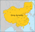
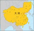
Re-centering the map of Qing dynasty (1765)
-
 Done
Done
Map of Qing dynasty in 1765

Article(s): ko:청나라
- Request
- The Sakhalin island was a part of the empire but it is currently running off the border of the image. The map needs to be re-centered to include the whole island. Can anyone help? --Benzenekim (talk) 07:17, 12 March 2022 (UTC)
- Graphist opinion(s)
![]() Request taken by En rouge (talk) 14:39, 27 May 2022 (UTC)
Request taken by En rouge (talk) 14:39, 27 May 2022 (UTC)
- Done
The width of the Qing Dynasty map has been enlarged:
- as suggested in [4] by @Geographyinitiative: on 2021-07-01 19:15
- as requested in [5] by @Benzenekim: on 2022-03-09 22:52
- as requested in Commons:Graphic_Lab/Map_workshop by Benzenekim on 2022-03-12 07:17
The map was adjusted:
- full display of Sakhalin
- extended Japanese coastlines
- extended Philippine coastlines
Additionally, the sibling files, in Spanish and Chinese, have also been updated:
-
 español
Done -
 中文
中文
Done


![]() Done En rouge (talk) 12:52, 28 May 2022 (UTC)
Done En rouge (talk) 12:52, 28 May 2022 (UTC)
Medellín location map from OpenStreetMap

Article(s): fr:Modèle:Géolocalisation/Medellin
- Request
- Update map. The current file on Commons doesn't show plenty of places added on OpenStreetMap since 2010, such as Túnel de Oriente, several metro lines or just streets. Please keep the same coordinates so the templates don't suffer any change. Thank you. --·×ald·es 06:33, 23 October 2022 (UTC)
- Graphist opinion(s)
XalD So what you are asking for is a new "screen print" of OSM in the same area and size as the source?
If this is so then this new map should be uploaded as a new version and for the source an update of the Description to state July 2010 would be needed.. --please ping me-- Goran tek-en (talk) 16:24, 21 November 2022 (UTC)
- Yes, the one we're currently using is quite outdated. ·×ald·es 17:03, 21 November 2022 (UTC)
![]() Request taken by --please ping me-- Goran tek-en (talk) 17:45, 21 November 2022 (UTC)
Request taken by --please ping me-- Goran tek-en (talk) 17:45, 21 November 2022 (UTC)
This draft is shown for proofreading only.
- This draft from today's OSM is very different, everything is smaller as resolution (on most screens and other stuff) is higher today than 2010 and there is so much more information on the map at OSM today. Is this what you want? Please always ping me, thanks. --please ping me-- Goran tek-en (talk) 19:08, 21 November 2022 (UTC)
- @Goran tek-en: Yes, that is correct. Thank you, --·×ald·es 20:54, 21 November 2022 (UTC)
XalD Now you can find it here file:Medellin location map November 2022.png.
- Please check all the information, also links for wikipedia, wikidata and structured data.
- If you are happy with this please put the code
"{{section re.solved|1=~~~~}}"(without the ".") on this request so it can be archived, thanks. Done --please ping me-- Goran tek-en (talk) 11:56, 22 November 2022 (UTC)
- This section was archived on a request by: ·×ald·es 23:44, 24 November 2022 (UTC)
Translating the Elizabeth line map into Malay
-
 The Elizabeth line route map as of May 2022
 -
 The Elizabeth line route map as of May 2022 in Malay language
Article(s): Laluan Elizabeth
- Request
- Hi. Can someone translate the image attached into Malay language (code lang: ms)? The translations are as follow (English → Malay):
- Elizabeth line operating as 3 separate sections (2022) → Laluan Elizabeth beroperasi sebagai 3 seksyen berasingan (2022)
- Above-ground station → Stesen atas tanah
- Station in tunnel → Stesen dalam terowong
- Interchange → Pertukaran
- 2 mi → 2 bt
- London fare zone inapplicable → Zon tambang London tidak terpakai
- Heathrow Airport. Special fares apply. → Lapangan Terbang Heathrow. Tambang istimewa dikenakan.
- Central London → London Tengah
- City Airport (proposed) → City Airport (dicadangkan)
- Special fares apply → Tambang istimewa dikenakan
- River Thames → Sungai Thames
Thank you and regards. -- 26 Ramadan (talk) 11:44, 3 June 2022 (UTC)
- Graphist opinion(s)
@26 Ramadan: Why don't you have a go at changing it yourself? It's extremelly easy as all you have to do is: download the svg, open the file using a text editor, search and replace the text and then upload under a new name. If for some reason, the replaced text doesn't fit properly, post here again and I'm sure someone will adjust it for you. Best, M.Bitton (talk) 16:56, 3 June 2022 (UTC)
- @M.Bitton: Done. Translated map as above. Thank you for the recommendation. 26 Ramadan (talk) 09:58, 6 June 2022 (UTC)
Fix the shape of Nevada in File:Prostitution in North America2.svg
-
 Prostitution in North America. It is legal in some parts of Nevada, so it is colored gray. However, the shape appears to be incorrect.
 -
 Blank map of North America with the states and provinces as of 1998 (is there a more recent map?).


Article(s): en:Sex tourism
- Request
- Please fix the shape of Nevada in File:Prostitution in North America2.svg as the borders do not appear to match the map projection where latitudes and longitudes should be perfectly vertical and horizontal. --Hanif Al Husaini (talk) 23:23, 26 November 2022 (UTC)
- Graphist opinion(s)
![]() Done Tcr25 (talk) 22:12, 7 December 2022 (UTC)
Done Tcr25 (talk) 22:12, 7 December 2022 (UTC)
Map of the Fens (Convert into SVG)
-
 Map of the Fens (Please convert to SVG and remove reference to the Isle of Axholme)
 -


Article(s): Various
- Request
- Please can a new version of this map which is dated from 2006 and not in SVG be created with all references to the Isle of Axholme to be removed as it is not part of the Fens with the towns and cities which are mentioned on the map along with the names of the fens and possibly the courses of the major rivers what flow within the Fens. (MOTORAL1987 (talk) 08:32, 10 May 2022 (UTC))
- Graphist opinion(s)
![]() Done – See new map above MOTORAL1987. Rcsprinter123 (talk) 21:49, 11 May 2022 (UTC)
Done – See new map above MOTORAL1987. Rcsprinter123 (talk) 21:49, 11 May 2022 (UTC)
- Oh thank you so much the new map is fantastic however can we make two final changes, please can Grimsby be removed as it’s nowhere near the Fens and also can a border be added just to show a rough outline of the area of the fens just like as shown in the map. (MOTORAL1987 (talk) 04:21, 12 May 2022 (UTC))
- OK, given that an update for you. Rcsprinter123 (talk) 21:28, 15 May 2022 (UTC)
Cheers May I request three further very minor alterations to the map please.
- 1. Can the towns of Downham Market and Market Deeping be added.
- 2. Can the red western border around Lindsay Level and Deeping Feen be modified slightly further westwards so it shows Market Deeping to properly show Deeping Fen and Market Deeping within it.
.jpg)
This map here shows in the best way what the outline of the red broundry in a more realistic way,
- 3. In a different colour can the county outlines of Lincolnshire, Cambridgeshire, Norfolk and Suffolk be added into the map too.
I hope this doesn’t cause too many issues as in too much information. (MOTORAL1987 (talk) 11:04, 15 June 2022 (UTC))
Examples of texts in maps ?
I uploaded File:Continental Basins of Mongolia - Asian Development Bank 2020.svg and used it on Wikipedia. But it looks small and ugly there, with all the text outside the frame. I want to edit it and put the names from the sidebar in the frame, hoping it won't block too much iof thetopographical features. Or possibly make tooltips. Can you point to some example or MOS of how it should be done with nice results ?

Danny lost (talk) 15:38, 18 March 2022 (UTC)
- Graphist opinion(s)
@Danny lost: Remove most of the text from the SVG map. This allows for avoding embeding the title of the map at the top and the small legend on the right. Use the template w:Template:Overlay to re-create the legend for each of the numbered features. This has addtional the advantage of being able to wikilink to articles like w:Tuul River.
In the article w:Land of the Blacks (Manhattan)#Development, I used this approach Overly template to add the legend. This approach has the advantage of reuse. The same SVG can be used across different languages. Ping me on this page if you have questions. - DutchTreat (talk) 13:17, 25 April 2022 (UTC)
- Thank you. This sounds helpful. I'll try it sometime... Danny lost (talk) 19:34, 4 May 2022 (UTC)
@Danny lost: Hi, it seems this image has not an appropriate license, and shall be removed from Commons. Its usage is only for personal use without written consent, see [6], "Copyright / Privacy" tab. Yours, En rouge (talk) 12:50, 28 May 2022 (UTC)
- @En rouge, hi, the document with the map has a prominent notice that reads: "Creative Commons Attribution 3.0 IGO license (CC BY 3.0 IGO)". I believe it is OK? Danny lost (talk) 12:05, 2 June 2022 (UTC)
- @Danny lost: hi, OK Danny, sorry for my previous comment.
- I saw that the website offered paid documents (and, for me, implicitly not a proper license for Commons).
- But, while downloading the document, I saw the CC BY 3.0 IGO license as you mention.
- Sorry again, yours, En rouge (talk) 23:06, 17 June 2022 (UTC)
Christmas map

Article(s): en:Christmas
- Request
Hello! Could four minor corrections be made to this map please.
The four minor mistakes in this map are
- South Sudan is missing
- Vojvodina is not an independent country. It is part of Serbia.
- Germany is still depicted as being divided with a West and East Germany.
- Nakhchivan should be coloured the same way as the rest of Azerbaijan
Thank You, --Leoboudv (talk) 11:18, 26 December 2022 (UTC)
- Graphist opinion(s)
![]() Request taken by Tcr25 (talk) 15:12, 27 December 2022 (UTC)
Request taken by Tcr25 (talk) 15:12, 27 December 2022 (UTC)
![]() Done updated and file replaced. Let me know if I missed anything ... Tcr25 (talk) 15:29, 27 December 2022 (UTC)
Done updated and file replaced. Let me know if I missed anything ... Tcr25 (talk) 15:29, 27 December 2022 (UTC)
- Comment: Thank you for all your kind help Tcr25 Everything is resolved. May I wish you a Happy 2023. Best Regards, --Leoboudv (talk) 11:53, 28 December 2022 (UTC)
Metro Systems map
-
 Map of World metro systems

Article(s): en:List of metro systems
- Request
- Please add Bangladesh in green as the Dhaka Metro opened. https://www.thedailystar.net/special-events/dhaka-metro-rail-opening/news/pm-opens-countrys-first-metro-rail-3207081?amp--208.127.190.114 20:40, 29 December 2022 (UTC)
- Graphist opinion(s)
![]() Request taken by Tcr25 (talk) 21:37, 2 January 2023 (UTC)
Request taken by Tcr25 (talk) 21:37, 2 January 2023 (UTC)
![]() Done —Tcr25 (talk) 21:37, 2 January 2023 (UTC)
Done —Tcr25 (talk) 21:37, 2 January 2023 (UTC)
Malay dialectal variation location map.svg
-
 Inspired from this
 -
 Add the borders
 -
 Add the borders
 -
 Add the borders


Article(s): ms:wikt:Templat:ms-dial
- Request
- This is inspired from File:Chinese dialectal variation location map.svg. For Malay, only Brunei, Indonesia, Malaysia, Singapore, Sri Lanka and Cocos (Keeling) Islands need to be highlighted. Please add the borders for Indonesia, Malaysia and Thailand in the map too. Make sure all the six countries mentioned can be seen in one picture the most. This map will be used to point all the dialects using coordinates just like in wikt:Module:zh/data/dial. --Tofeiku (talk) 11:25, 24 July 2022 (UTC)
- Graphist opinion(s)
Map of Vietnam within the Japanese Empire
-
 The Japanese Empire.
 -
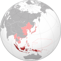 Example map with the Netherlands East-Indies (for reference).
 -
Vietnam (for reference).
.svg)

Article(s): [[]], "Japanese occupation of Vietnam" (future article).
- Request
- Details of your request go here… I would like to request the creation of a map showcasing Vietnam within the Japanese Empire during the war. Above are example maps, note that while Japan occupied all of French Indo-China, I'm only requesting a specific map with Vietnam (though whomever takes this can just as well highlight French Indo-China in a separate SVG map as that would also be a useful image).
- Basically the same categories as the map of the Japanese occupation of the Netherlands East-Indies, so "Locator maps of the Empire of Japan", "Greater East Asia Co-Prosperity Sphere", and "Maps showing 20th-century history". --Donald Trung 『徵國單』 (No Fake News 💬) (WikiProject Numismatics 💴) (Articles 📚) 10:54, 7 September 2022 (UTC) .
Title - Vietnam within the Japanese Empire (orthographic projection).svg
Caption & Description - A map of Tonkin, Annam, and Cochinchina within the Japanese Empire at its greatest extend during World War II.
License - (As you wish.)
Category - "Category:Locator maps of the Empire of Japan" - "Category:Maps of the history of Vietnam".
--Donald Trung 『徵國單』 (No Fake News 💬) (WikiProject Numismatics 💴) (Articles 📚) 12:03, 7 September 2022 (UTC)
- Graphist opinion(s)
![]() Request taken by —Tcr25 (talk) 14:26, 5 January 2023 (UTC) How does this look, Donald Trung?
Request taken by —Tcr25 (talk) 14:26, 5 January 2023 (UTC) How does this look, Donald Trung?
-
 Vietnam within the Japanese Empire
.svg)
- @Tcr25: , the map looks fine. Is it possible to re-colour it like "File:Japanese Indies.svg"? Also, I forgot to add this to the original request but can you also make identical maps of Laos and Cambodia to use in articles like this one? --Donald Trung 『徵國單』 (No Fake News 💬) (WikiProject Numismatics 💴) (Articles 📚) 03:08, 7 January 2023 (UTC)
- Do you mean recolor as pink and red (instead of shades of green)? — Tcr25 (talk) 03:54, 7 January 2023 (UTC)
- Tcr25, Yes, in order to harmonise it with other maps in the category. -- — Donald Trung 『徵國單』 (No Fake News 💬) (WikiProject Numismatics 💴) (Articles 📚) 20:41, 8 January 2023 (UTC)
- Color update Done. I'll look at Laos and Cambodia maps later. — Tcr25 (talk) 00:00, 9 January 2023 (UTC)
- @Tcr25: , Thank you very much, as this request mainly revolves around Vietnam I'll mark it as "Completed". --Donald Trung 『徵國單』 (No Fake News 💬) (WikiProject Numismatics 💴) (Articles 📚) 16:02, 30 January 2023 (UTC)
- Color update
- Tcr25, Yes, in order to harmonise it with other maps in the category. -- — Donald Trung 『徵國單』 (No Fake News 💬) (WikiProject Numismatics 💴) (Articles 📚) 20:41, 8 January 2023 (UTC)
- Do you mean recolor as pink and red (instead of shades of green)? — Tcr25 (talk) 03:54, 7 January 2023 (UTC)
- This section was archived on a request by: Donald Trung 『徵國單』 (No Fake News 💬) (WikiProject Numismatics 💴) (Articles 📚) 16:02, 30 January 2023 (UTC)
London railway stations and termini
-
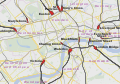 Description of first image

Article(s):
- Request
- Needs updating and drawing of borders and lines.
- Details of your request go here…
I noticed that there was no free map on Wikipedia showing the various railway stations in central London on a map, along with their lines and destinations. The closest I saw was this: File:Major railway stations of London map.svg, which is quite well made with a good map background and lines, but isn't complete (e.g. Moorgate is missing), outdated now (with opening of Elizabeth line) and it only shows a border for the City which doesn't tell much.
So I set out to create one myself using that SVG as a stepping stone. I don't know how to work with SVG hence I created my file in a separate software using layers in PNG format. The result was this: File:Railway stations, lines and termini in central London.png. My map shows quite clearly all the stations along with coloured lines (inc. the new Elizabeth line), the names/operators, and commuter destinations.
However I know it'd be best if that original SVG can be improved to bring it in line with that - the problem is I don't know how to do it myself so am requesting if others are willing to perform it. The changes that I see ideally need to be made to that SVG are:
- Update it to show the Elizabeth line railway track
- Add missing termini like Moorgate, as well as other stops in the area like City Thameslink
- Put accurate borders with purple outlines for the other boroughs in the area (Westminster, Camden, Lambeth etc.)
With an improved and complete version like that, we'd have a good raw map, and it can be used to create a version with coloured lines and operator/destination names as I did before with that PNG.
--Manche Captain (talk) 16:43, 5 July 2022 (UTC)
- Graphist opinion(s)
- Manche Captain: Having just had a think about this, I'm not completely sure that all the suggestions you have made are required. For example, Moorgate station is a category E station (it only serves Herts commuters), and the basis for the choice of termini included on Hbf878's map is that they are all Category A national hub level stations. On the matter of borough boundaries, I believe that showing the City serves to highlight the relationship between it and the termini, which is a historically important point, with several penetrating its edge and the group to the north-west which were made feasible by the opening of the Metropolitan Railway to effectively extend them to the City. Complicating the map with other boundaries - why is Westminster vs Camden a helpful distinction here? - is further distraction to add to the already complex network of railways and roads. I think the same goes for colours and labels as per your PNG effort - it may be too busy to be useful. Updating with the Elizabeth line is certainly something that can and should be done though. It's also worth noting that Hbf878 is still active with Covid graphs on Commons and may respond to your question on what could be done. Rcsprinter123 (notify) 17:15, 8 August 2022 (UTC)
South Sudan borders required in orthographic maps
-
File:Russian Federation (orthographic projection).svg Done NOT uploaded yet!
-
File:Rossija globus.png Done
-
File:Kashmir (orthographic projection).jpg should be like File:Kashmir (orthographic projection).svg and the green dot in the JPG map needs to be removed Done
-
File:German east africa map.png Done
-
File:German sw africa map.png Done
-
File:German east africa map.png Done
-
File:Iraq (orthographic projection).svg Done NOT uploaded yet!
-
File:Cyprus (orthographic projection).png Done
-
File:East Asian Cultural Sphere - Updated.png Done
-
File:East Asian Cultural Sphere - Sinocentist.png Done
-
File:Greater Mongolia (orthographic projection).png Done
Article(s): Numerous articles across Wikipedia.
- Request
- The borders of South Sudan need to be added in these orthographic maps. --Maphobbyist (talk) 17:32, 20 October 2022 (UTC)
![]() Request taken by --please ping me-- Goran tek-en (talk) 20:20, 9 February 2023 (UTC)
Request taken by --please ping me-- Goran tek-en (talk) 20:20, 9 February 2023 (UTC)
- @Maphobbyist: You will have to check them all and remove any necessary template or so, thanks. --please ping me-- Goran tek-en (talk) 16:17, 10 February 2023 (UTC)
For some reason I'm prohibited to upload a new version of File:Russian Federation (orthographic projection).svg and File:Iraq (orthographic projection).svg. Can you please sort out why or what to do, thanks. --please ping me-- Goran tek-en (talk) 16:17, 10 February 2023 (UTC)
- This section was archived on a request by: --please ping me-- Goran tek-en (talk) 15:46, 14 February 2023 (UTC)
File:Meemu Atoll.png contains wrong island names
-
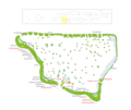 Map with wrong island names

Article(s): en:Meemu Atoll and in 15 other language versions, plus articles on individual islands in de and ceb language versions [7]
- Request
- The map is nice, but the names of the islands do not fit the official list. Sometimes a name goes to the wrong island. Rather than making a request for deletion, I hope that somebody can fix this. (This is beyond my abilities, unfortunately.)
The issue came up in a discussion in de.wikipedia. Apparently some map makers are very "creative" when assigning names to the various islands. There is one source, onemap.mv, which is "the authoritative source for the National map of Maldives developed and maintained by the Maldives Land and Survey Authority under it’s mandate of creating the National Chart and maintaining the National land registry."[8] I strongly suggest to use the names shown at https://onemap.mv/. These names are sometimes different from those found at Google maps and sometimes also different from those found at a different government site, atollsofmaldives.gov.mv. Which makes the issue even more confusing. Examples from north to south (I actually find it easier to read and compare the table with maps from the bottom/south to the top/north):
| onemap.mv | Meemu_Atoll.png | atollsofmaldives.gov.mv | Google Maps |
|---|---|---|---|
| LD1626 | not existent (or combined with next) | not existent | not existent |
| LD1627 | Kekuraalhuvelee | not existent | not existent |
| Kekuraalhuveli | Gasveli | Gasveli | no Name |
| Dhekunuboduveli | Dhekunuboduveli | Dhekunuboduveli | no Name |
| Gasveli | Kudausfushi | Kuda usfushi | Mahufuri |
| somewhat bigger geographic gap | |||
| Kudausfushi | Maausfushi | Maa usfushi | no Name |
| Maausfushi | Maahuraa | no Name | no Name |
| Maahuraa | Fenfuraaveli | Maahuraa | Haafushi |
| Fenfuraaveli | Haafushi | Fenfuraaveli | Fenfuraaveli (only when name is searched for) |
| Kolhufushi (west of it 3 small islands) | Kolhufushi (no small islands) | Kolhufushi (no small islands) | Kolhufushi |
| Dhihthun'di | Dhiththundi (note spelling) | Dhihthun'di | no Name |
To find the area at onemap.mv, for example search for Kolhufushi. When going north from this region, there are also some deviations with the actual islands, not just the names, of "our" map and the official site. These probably also would need correction. So far I did not dare to check the maps of the other Maldivan attols. User:Helix84 is listed as creator of the png, User:Snowdog created the predecessor jpg. The text there states: Map originally vector'ed by Hassan Waheed, Aabaadhuge of Thinadhoo]] island. Not sure what that means. --Skopien (talk) 16:54, 20 March 2022 (UTC)
- Graphist opinion(s)
- @Skopien: Hi, do you have seen this recent upload:
 ?
? - Does it fit your requirements?
- yours, En rouge (talk) 21:40, 26 May 2022 (UTC)

- Dear En rouge, sorry for not replying earlier, real life kept me quite busy. The new upload is great, showing none of the problem listed above. I'll make a deletion request on the old file as soon as I get to it and then we can close here. Skopien (talk) 15:39, 31 August 2022 (UTC)
The requester did write we can close here so I'm doing that.
![]() Done
Done
- This section was archived on a request by: --please ping me-- Goran tek-en (talk) 15:54, 1 March 2023 (UTC)
Adjacent maps
Article(s): [[]]
- Request
- Don't know whether this is the place to ask. I have been looking at maps from old atlases that thoroughly cover an area. Fire insurance atlases, specifically, which provide much information about local economic history. While tracing old canals and such, I noticed that the original paper maps provided an easy way for the reader to turn to the maps of adjacent areas. This doesn't work on Commons, however, because there is no link. Seems to me, a template could make a 3x3 square with links to adjacent maps on the north, northeast, east, southeast, etc so we just have to click to go to the correct one. Is a template the right way to do this, and does such a template or other method exist? Jim.henderson (talk) 23:39, 5 September 2022 (UTC) --Jim.henderson (talk) 23:39, 5 September 2022 (UTC)
- Graphist opinion(s)
Requesting map for dialects of Azerbaijani
I would like to request a map that can be used for dialect synonyms of Azerbaijani on English Wiktionary. The data and coordinates come from here: https://en.m.wiktionary.org/wiki/Module:dialect_synonyms/az And I would like to be able to add more points later.
The map should include the Republic of Azerbaijan, Armenia, eastern Georgia and northwestern Iran. Allahverdi Verdizade (talk) 15:23, 26 November 2022 (UTC)
- For inspiration: similar map for Finnish dialects https://en.wiktionary.org/wiki/Template:fi-dial-map/feature/Kettunen1940_001 Allahverdi Verdizade (talk) 16:34, 26 November 2022 (UTC)
I have offered to help Allahverdi Verdizade in communicating his request. Here it is rephrased/clarified:
-
A map for showing information about Azerbaijani dialects.
Article(s): Will be linked to from entries like en:wikt:itburnu, en:wikt:şəlalə, and en:wikt:nəlbəki. Compare the usage of File:Chinese dialectal variation location map.svg, a copy of which, en:wikt:Template:zh-dial-map/串, is linked to from en:wikt:串 in the synonyms section.
- Request
- A equirectangular map of Azerbaijan, Armenia, eastern Georgia, and northwestern Iran.
- A SVG plate carrée location map (see Template:2008 Standard Location maps and Template:Location map notice) showing the area within the following geographic limits:
- N: 42.2° N
- S: 36.5° N
- E: 50.0° E
- W: 43.4° E
- Please show country borders in black, land with the color #fefee9, and bodies of water with the color #c6ecff. —The Editor's Apprentice (Talk) 02:34, 4 December 2022 (UTC)
- Graphist opinion(s)
@Allahverdi Verdizade: I can probably help but please give me GPS coordinates instead, thanks. --please ping me-- Goran tek-en (talk) 18:12, 18 February 2023 (UTC)
- Hi Goran tek-en, thank you for offering you assistance! As mentioned above I am helping Allahverdi Verdizade get his request fulfilled. Can you clarify what you mean by "give you GPS coordinates instead"? Do you mean you want the limits of the map in degrees-minutes-seconds form like 42° 12' 0"? Or do you mean you want the the latitude and longitude for the points that define the northwest and southeast extremes of the requested map? Or is there something else you're looking for? Thanks and take care. —The Editor's Apprentice (Talk) 02:17, 19 February 2023 (UTC)
- @The Editor's Apprentice I have a hard time to translate the geographic limits to something I'm used to.
- This link gives you a place (Istanbul) which has the coordinates 41.040862, 28.976360. If you right click on the position mark (or the place you want) you get the coordinates, just click on them and they will copy.
- If you could give me the same type of coordinates (e.g. 41.040862, 28.976360) for Top Left and Bottom Right corners it would help me, thanks. --please ping me-- Goran tek-en (talk) 18:38, 19 February 2023 (UTC)
- @Allahverdi Verdizade @The Editor's Apprentice
- I have checked more and I got this area (black square), is this correct? --please ping me-- Goran tek-en (talk) 18:25, 23 February 2023 (UTC)
- @Goran tek-en Almost. Could you please expand the square so that 1. all of the Absheron peninsula is inside it and 2. Qazvin city is inside it too. Allahverdi Verdizade (talk) 18:34, 23 February 2023 (UTC)
- @Allahverdi Verdizade Like this? --please ping me-- Goran tek-en (talk) 20:03, 23 February 2023 (UTC)
- @Goran tek-en Yes, perfect. Allahverdi Verdizade (talk) 20:11, 23 February 2023 (UTC)
- @Allahverdi Verdizade Like this? --please ping me-- Goran tek-en (talk) 20:03, 23 February 2023 (UTC)
- @Goran tek-en Almost. Could you please expand the square so that 1. all of the Absheron peninsula is inside it and 2. Qazvin city is inside it too. Allahverdi Verdizade (talk) 18:34, 23 February 2023 (UTC)
![]() Request taken by --please ping me-- Goran tek-en (talk) 14:35, 24 February 2023 (UTC)
Request taken by --please ping me-- Goran tek-en (talk) 14:35, 24 February 2023 (UTC)
- @Allahverdi Verdizade @The Editor's Apprentice
- Does it have to be an equirectangular map?
- I don't have the knowledge to download data sets and create one myself so I depend on OpenStreetMap which uses Spherical Mercator projection, can I use this?
- If not I'm sorry to have wasted your time and that I didn't see that you (maybe) specifically wanted an equirectangular map. --please ping me-- Goran tek-en (talk) 15:23, 24 February 2023 (UTC)
- Ideally it should be equirectangular. If its not equirectangular then accurately putting dots on the map using code becomes fairly difficult and its no longer technically a location map. With that said, the fact that the area covered by the map is fairly small decreases the discrepancies that would be created between actual locations and displayed locations if one where to set up the code to naively under the assumption that the map was actually equirectangular.
- To demonstrate and investigate these discrepancies I created this image/graph. To explain it, I took the map area from one of @Goran tek-en's screenshots and then overlaid it with dots for various cities across the region. The dots are in the spots for the cities if the map was actually equirectangular. Since its, not there are small differences in where the cities appear in the screenshot and their corresponding dots. You can zoom in to see this a little more clearly. By the way, I realized that Goran tek-en actually uses OpenStreetMap to make their maps, not Google Maps, but according to the page the linked to about the Web/Spherical Mercator projection the two websites use the same projection so it shouldn't matter.
- Anyway, its ultimately up to @Allahverdi Verdizade to judge how serious the discrepancies would be with a non-equirectangular map and whether they are an acceptable inaccuracy. —The Editor's Apprentice (Talk) 00:16, 25 February 2023 (UTC)
- @The Editor's Apprentice @Allahverdi Verdizade Yes it's not such a big difference within this area as you say. We do have maps with equirectangular projection here at commons but they are mainly world maps and when zoomed in like this they are not precis in any way so to me it would be bad to use them.
- For your image/graph: if GPS coordinates are used (e.g. 49.864629,40.406100) like you do, can't that be used for the dialects as you know there position, would that not be correct on a Spherical Mercator? Or maybe that Template works only with equirectangular maps and can't be changed, I don't have that knowledge.
- There are not many free maps with equirectangular projection but you can create yourself (if you have the knowledge using e.g. QGIS and data sets) and Justinrleung has done so creating Chinese dialectal variation location map so why don't you ask that user if they would help out.
- Just let me know what you want to do, thanks. --please ping me-- Goran tek-en (talk) 12:14, 25 February 2023 (UTC)
- @Goran tek-en I think we can proceed with the OpenStreetMap as the base map. Thank you. Allahverdi Verdizade (talk) 22:34, 25 February 2023 (UTC)
- @Allahverdi Verdizade I don't know how you create your posts here but I don't get the Ping so I didn't see this until now, I will be back with a draft. --please ping me-- Goran tek-en (talk) 17:04, 28 February 2023 (UTC)
- @Allahverdi Verdizade
- Color for borders are #646464 according to the Location_maps Convention that we use.
- You haven't told me in which countries you will add information regarding the dialects. If it's not all of the countries this map covers please say which are out of focus so I can color them grey as that is also a convention.
- Draft-3.
- --please ping me-- Goran tek-en (talk) 15:51, 1 March 2023 (UTC)
- Looks very good. No gray countries are needed. Azerbaijani dialects can be found everywhere in the region! Allahverdi Verdizade (talk) 17:37, 2 March 2023 (UTC)
- @Goran tek-en hope you get the ping now. Allahverdi Verdizade (talk) 17:37, 2 March 2023 (UTC)
- @Allahverdi Verdizade Ping worked now, thanks.
- I will need the following;
- Name of the file
- Description (/language)
- Captions/s (/language)
- Category/ies at commons
- Structured data/Items portrayed in this file, the Q#, to be able to upload it at commons, thanks.
- I will need the following;
- --please ping me-- Goran tek-en (talk) 18:04, 4 March 2023 (UTC)
- @Allahverdi Verdizade Ping worked now, thanks.
- @Allahverdi Verdizade
- @Allahverdi Verdizade I don't know how you create your posts here but I don't get the Ping so I didn't see this until now, I will be back with a draft. --please ping me-- Goran tek-en (talk) 17:04, 28 February 2023 (UTC)
- @Goran tek-en I think we can proceed with the OpenStreetMap as the base map. Thank you. Allahverdi Verdizade (talk) 22:34, 25 February 2023 (UTC)
- @The Editor's Apprentice @Allahverdi Verdizade Yes it's not such a big difference within this area as you say. We do have maps with equirectangular projection here at commons but they are mainly world maps and when zoomed in like this they are not precis in any way so to me it would be bad to use them.
@Allahverdi Verdizade I haven't got the information I asked for so I have uploaded the map and added the information I think is correct.
- You will have to check everything and now you can find it here Basemap for dialect synonyms of Azerbaijani in Spherical Mercator projection.
- If you are happy with this please put the code
"{{section re.solved|1=~~~~}}"(without the ".") on this request so it can be archived, thanks. Done --please ping me-- Goran tek-en (talk) 16:43, 8 March 2023 (UTC)
- Many thanks to you!
Please set China to grey as it doesn't legally recoginize same-sex unions at all!
-
 Description of first image
 -
Description of second image (if needed)
-
Description of third image (if needed; don't request too many at once, though)

Article(s): [[]]
- Request
- In the graph China is set to blue which is very misleading. The author set it to blue as he/she thought China had legal guardianship law. But this law was made for any two consenting adults. It is not for same-sex couples benefits at all! Actually, the Chinese government is trying to weaken its usage by same-sex couples. Such laws can be found in many other countries. Since it's not made for same-sex relationship protection or recognition purpose, as a Chinese citizen, I strongly suggest that we change China from Limited domestic legal recognition to Same-sex unions not legally recognized. e.g. Almost all the countries have laws allowing a person to nominate his/her heir by will, which can be taken advantaged by same-sex couples. Does this mean that all countries have limited domestic legal recognition? The answer is obviously No unless this country has special laws for inheritance between same-sex couples. If we set China to blue, why don't we do so to many other grey countries which also have similar legal guardianship laws between two consenting adults?
Thank you!
- Graphist opinion(s)
It would have been great if you had signed your request. I (and I think many others) don't work on a not signed request. --please ping me-- Goran tek-en (talk) 13:52, 27 September 2022 (UTC)
4 more departments in Region Tahoua, Rép. du Niger, since 2011
-
 Made 2006, outdated
 -
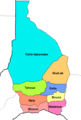 Left map cropped, outdated
 -
 Tahoua location map
 -
 Map showing the Keita department


.svg)
.svg)
- Artikel
- The outdated maps are already used in the articles about the missing departments in German Wikipedia: Bagaroua, Malbaza, Tassara and Tillia
- Anfrage
- The departments Bagaroua, Malbaza, Tassara and Tillia should be added in the maps. - Source for further information: Two maps from 2017 showing all departmens are available in this government paper of the Rép. du Niger (pp: 10-13). Thank you in advice. --Temdor (talk) 14:55, 10 October 2022 (UTC)
- Meinung der Bearbeiter
![]() Request taken by M.Bitton (talk) 01:35, 16 October 2022 (UTC)
Request taken by M.Bitton (talk) 01:35, 16 October 2022 (UTC)
![]() Done @Temdor: I have uploaded a location map of Tahoua as well as a department's map. If you're happy with how they look, I will upload the maps of the other departments. M.Bitton (talk) 22:07, 17 October 2022 (UTC)
Done @Temdor: I have uploaded a location map of Tahoua as well as a department's map. If you're happy with how they look, I will upload the maps of the other departments. M.Bitton (talk) 22:07, 17 October 2022 (UTC)
- @M.Bitton: , in my opinion one map schould show all departments. But I understand your intention to make the maps multilingual. One question. The border to district Agadez has changed? Haven't realized this. The work is piling up. Thank you for your enthusiasm. Thank you very much. -- Temdor (talk) 19:44, 18 October 2022 (UTC)
- @Temdor: The borders look like they're shown on this map and others like it. M.Bitton (talk) 23:29, 19 October 2022 (UTC)
- Hello @M.Bitton: , I tried to research the exact date when the border between region Tahoua and region Agadez had changed. The maps from 2017 show the old border. The first map showing the new border was dated from February 2018. I suppose it changed about turn of the year. Obviously there are several maps in commons waiting to be updated. Thank you very much. -- Temdor (talk) 00:21, 22 October 2022 (UTC)
- @Temdor: The borders look like they're shown on this map and others like it. M.Bitton (talk) 23:29, 19 October 2022 (UTC)
Liaoning Maps
-

-

-

-
 first test using data from University of Texas, updated to 2015


.svg)
Article(s): en:Nanpiao District, en:Huludao
- Request
- Obvious discrepancy between this maps should be corrected.
- Obvious discrepancy between this maps should be corrected: Nanpiao (upper right) is much smaller in the first two maps than in the third map (where it is in pink). The current versions of the first two maps could later be used as historical maps, but the current need on Wikipedia is for a present-day map. --Geographyinitiative (talk) 22:07, 8 September 2022 (UTC)
- Graphist opinion(s)
![]() Request taken by Sette-quattro (talk) 07:58, 18 October 2022 (UTC)
Request taken by Sette-quattro (talk) 07:58, 18 October 2022 (UTC)
- @Geographyinitiative: Before going on, can you please confirm me that this is the current subdivision? https://geodata.lib.utexas.edu/catalog/stanford-xg824mz9880. I see four counties in Huludao: Suizhong, Janchang, Xingcheng and Jinxi. Otherwise would be great if you can provide me a link to an up-to-date shapefile Sette-quattro (talk) 16:09, 18 October 2022 (UTC)
- Thanks for looking into this. I have no shapefile. Baidu Baike's article for 南票区 (Nanpiao District) has a map consistent with the pink area on the third map above. If you type in 南票区 on Google Maps or Baidu Maps, it shows an area broadly consistent with the pink area on the third map. I couldn't figure out how to use the above UTexas map you link, but according to 2021 stats of the PRC government here, Huludao should include Lianshan, Longgang, Nanpiao, Suizhong, and Jianchang Districts as well as Xingcheng County-level city. --Geographyinitiative (talk) 18:59, 18 October 2022 (UTC)
- @Geographyinitiative: I uploaded a first draft using the aforementioned source as a reference, but if i got it well that subdivision is no longer the current one. I'm not able to read/write in chinese but maybe you could help me in finding the data as geojson/shapefile. another solution could be to use the boundaries represented on OpenStreetMap: https://www.openstreetmap.org/#map=10/41.0581/120.7658. What do you think? Sette-quattro (talk) 14:26, 19 October 2022 (UTC)
- Thanks for looking into this. I have no shapefile. Baidu Baike's article for 南票区 (Nanpiao District) has a map consistent with the pink area on the third map above. If you type in 南票区 on Google Maps or Baidu Maps, it shows an area broadly consistent with the pink area on the third map. I couldn't figure out how to use the above UTexas map you link, but according to 2021 stats of the PRC government here, Huludao should include Lianshan, Longgang, Nanpiao, Suizhong, and Jianchang Districts as well as Xingcheng County-level city. --Geographyinitiative (talk) 18:59, 18 October 2022 (UTC)
- @Geographyinitiative: Before going on, can you please confirm me that this is the current subdivision? https://geodata.lib.utexas.edu/catalog/stanford-xg824mz9880. I see four counties in Huludao: Suizhong, Janchang, Xingcheng and Jinxi. Otherwise would be great if you can provide me a link to an up-to-date shapefile Sette-quattro (talk) 16:09, 18 October 2022 (UTC)
Rail map file requests
-
 Raster file #1
 -
 Raster file #2
 -
 Raster file #3
 -
 Raster file #4
 -
 Raster file #5
 -
 Raster file #6
 -
 Vector file with invalid code
 -
 Vector file missing Silver Line
 -
 Create new original vector file
 -
 Create new original vector file
 -
 Create new original vector file
 -
 Create new original vector file


.svg)


Article(s): Miscellaneous
- Request
- Hello! Please create vector versions of the raster map files, fix the invalid code in the first vector file, add the Silver line to the second vector file, and create new original vector files for the last four vector files. Thank you! --OrdinaryJosh (talk) 06:42, 28 October 2022 (UTC)
- Graphist opinion(s)
Highlight East timor
-
 Indonesia in 1993 with east timor
 -
 Reference 2
.svg)

Article(s): New Order
- Request
- Please Highlight East Timor like New Zealand territories in the second image. Also change the color please.
- Graphist opinion(s)
Pinging @Mhatopzz, Can you clarify what you're wanting here? Do you want East Timor highlighted in a solid color (but different from the green used on New Zealand)? Do you want East Timor highlighted with a shaded circle like the New Zealand territories, but a different color? Do you want only East Timor highlighted (removing the color/shading on NZ and the highlighted territories)? Thanks, Tcr25 (talk) 15:51, 7 December 2022 (UTC)
Requesting new versions of two maps with new colours
-
 Global map of countries by age of which people can vote.
 -
 Global map of countries by age of which people attain adulthood


Article(s): en:Age of majority, en:Voting age
- Request
- Request that a new version of hese maps be created that uses different, distinct colours for each age. Some colours, such as those used for age 20 and 17, and 18 and 16 are too similar to each other and can lead to confusion, especially for those with sight issues. Suggested alternate colours: red, black, blue, yellow, purple, and green. Editor ping upon request - Goran tek-en. Helper201 (talk) 17:44, 26 November 2022 (UTC)
- Graphist opinion(s)
![]() Request taken by --please ping me-- Goran tek-en (talk) 18:14, 26 November 2022 (UTC)
Request taken by --please ping me-- Goran tek-en (talk) 18:14, 26 November 2022 (UTC)
@Helper201- ----
- Those drafts are PNG versions of the original SVG file I'm working in and will upload to commons.
- Those drafts are shown for proofreading only.
- ----
Age_of_Majority_-_Global-1, I have checked so those colors should work for most people with color deficiency, feedback thanks. --please ping me-- Goran tek-en (talk) 18:23, 28 November 2022 (UTC)@Helper201 I do need your support as above to be able to continue the work on your request, thanks. --please ping me-- Goran tek-en (talk) 11:30, 2 December 2022 (UTC)@Goran tek-en I think the colours for 16 and 21, as well as 19 and 20 are too similar to each other, being shades of the same colour. Helper201 (talk) 00:46, 6 December 2022 (UTC)- @Helper201 If you have any color deficiency please tell me so I can try to view it like you do.
- In this image-colors picked, you can see which colors I picked for each age (where the black lines are). They are not "shades of the same color". Below there are colors for the three most common color deficiencies, there some colors are different shades but not the ones you are writing about.
So I'm sorry, I don't understand what you mean, please try to explain in another way, thanks. --please ping me-- Goran tek-en (talk) 12:20, 6 December 2022 (UTC)- Hi @Goran tek-en, Sorry, I didn't see the offer to help here. I reworked the Voting Age map already using the Okabe–Ito Color Universal Design colorblind-safe palette. I didn't do anything with the Age of Majority map (I hadn't seen that request), but if you use the CUD palette, you should be good for most colorblind users. — Tcr25 (talk) 13:52, 6 December 2022 (UTC)
@Tcr25: , @Helper201: I did use a 12-color palette for color deficiency for those colors.
As you have updated one of those maps (I couldn't know you were working on it as you hadn't "taken it" here.) I think the best is if you do the other also and please use the codes provided here so others can see who is working on what so we don't do double work, thanks. So hereby I withdraw my "take". --please ping me-- Goran tek-en (talk) 15:00, 6 December 2022 (UTC)
- Sorry about that @Goran tek-en. I saw the request that was made on the Voting Age file's page, and only found the request here after that update was done. — Tcr25 (talk) 15:46, 6 December 2022 (UTC)
- @Tcr25 No problem, just glad you are working on this, thanks. --please ping me-- Goran tek-en (talk) 18:26, 6 December 2022 (UTC)
- Both maps now Done, so ... Tcr25 (talk) 18:32, 6 December 2022 (UTC)
- @Tcr25 @Goran tek-en I still think the colours for 19 and 20, and 17 and 21 are too similar to each other, being they are simply different shades of the same colour (two shades of blue and two shades of orange). Maybe change one to brown and another to purple, or some other completely different colours. Helper201 (talk) 04:23, 9 December 2022 (UTC)
- @Helper201: , 19 and 20 are shades of blue, 16 and 21 are shades of orange, but they're quite distinct from one another. They also resolve well for most forms of colorblindness (according to simulation tools), although it is clearest for readers with deuteranopia. Adding purple and brown to the mix would likely decrease accessibility by creating more pairs that colorblind users cannot distinguish between. — Tcr25 (talk) 13:26, 9 December 2022 (UTC)
- @Tcr25 @Goran tek-en I still think the colours for 19 and 20, and 17 and 21 are too similar to each other, being they are simply different shades of the same colour (two shades of blue and two shades of orange). Maybe change one to brown and another to purple, or some other completely different colours. Helper201 (talk) 04:23, 9 December 2022 (UTC)
- Both maps now
- @Tcr25 No problem, just glad you are working on this, thanks. --please ping me-- Goran tek-en (talk) 18:26, 6 December 2022 (UTC)
Turkey vulture range map
-
 Current JPG unsourced range map

Article(s): en:Turkey vulture ![]()
- Request
- Hi! Our current range map is an unsourced JPG file that doesn't match with the IUCN's map (especially in Uruguay). An SVG file based on a reliable source would be amazing: BirdLife International. 2018. Cathartes aura. The IUCN Red List of Threatened Species 2018: e.T22697627A131941613. https://dx.doi.org/10.2305/IUCN.UK.2018-2.RLTS.T22697627A131941613.en. Accessed on 14 December 2022. Thanks for any help you can provide. --A455bcd9 (talk) 11:20, 14 December 2022 (UTC)
- Graphist opinion(s)
New topographic map of Chongqing – issues
Article(s): cs:Čchung-čching (Czech Wiki)
- Request
- Hello, I'm trying to make a new, detailed, topographic map of Chongqing, a province-level municipality in China, however I'm having issues uploading it: the Upload Wizard states that "This file did not pass file verification." The map was made in QGIS, then I added name labels of the various mountain ranges (in Czech language), and added some finishing touches in Inkscape (scale, elevation legend etc.). I've tried to figure out what's wrong (validation), and there seem to be some issues with whatever I add on top of the bare map (text, labels, etc.), however I don't think I'd know how to fix it. Here's a Catbox link to the .svg map, feel free to download it, change it and, hopefully, correct it! Also - I'm not sure whether the size is appropriate, I'd like the map to be fully readable after a zoom-in, so please feel free to enlarge it if you see fit. Thank you! --Kubeji (talk) 22:30, 28 December 2022 (UTC)
- I'm taking a look at it! Remsense (talk) 22:51, 2 February 2023 (UTC)
- Graphist opinion(s)
File:US and Russian bases and facilities.jpg
-
File:US and Russian bases and facilities.jpg
Article(s): Numerous articles across Wikipedia.
- Request
- In File:US and Russian bases and facilities.jpg:
- Azerbaijan needs to be colored in white, because Azerbaijan never hosted a US military base, nor does it host a Russian base.
- Georgia needs to be colored in blue (like Belarus, Moldova and Armenia), because Georgia never hosted a US military base. It only has Russian military bases in breakaway Abkhazia and South Ossetia.
- The border of South Sudan, which became independent in 2011, needs to be added. Both South Sudan and Sudan do not host any US or Russian military bases, so their color stays unchanged. --Maphobbyist (talk) 18:40, 20 October 2022 (UTC)
- Graphist opinion(s)
![]() Request taken by --please ping me-- Goran tek-en (talk) 20:02, 9 February 2023 (UTC)
Request taken by --please ping me-- Goran tek-en (talk) 20:02, 9 February 2023 (UTC)
- Done @Maphobbyist: You have to check this and if fine mark it resolved, thanks. --please ping me-- Goran tek-en (talk) 20:19, 9 February 2023 (UTC)
- @Goran tek-en: --Maphobbyist (talk) 20:59, 13 February 2023 (UTC)
- @Maphobbyist Why did you ping me without any message for those two requests?
- If you want to close/archive them you have to put out the code I described for you. --please ping me-- Goran tek-en (talk) 13:17, 14 February 2023 (UTC)
- @Goran tek-en: --Maphobbyist (talk) 20:59, 13 February 2023 (UTC)
Korean Islands Problems
-
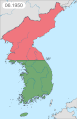 Korean War Map

Article(s): :en:Korean War
- Request
- Issue A: Baengnyeongdo is under South Korean administration.
Issue B: Ulleungdo, larger than Baengnyeongdo, is omitted from the map. See page for details.
--Geographyinitiative (talk) 17:46, 9 July 2022 (UTC)@Geographyinitiative I could help you with this but I will need your help along the way as the description page describes more and other specific issues depending on which image (time/frame) in the GIF animation we are talking about.So please get back to me if you will be here to help me with your knowledge, thanks. --please ping me-- Goran tek-en (talk) 14:08, 23 November 2022 (UTC)@Geographyinitiative Do need your assistance, just ping me and add needed info, thanks. --please ping me-- Goran tek-en (talk) 15:57, 1 March 2023 (UTC)- @Goran tek-en: I am not a Korea expert. However, (A) the 07.1953 image shows Ongjin County, Incheon (including Baengnyeongdo) in pink, whereas the armistice says that those islands are under ROK administration (as they are at til now). Further (B) Ulleungdo is not shown on the map at all, despite being larger than Baengnyeongdo and being within the lat/long scope of the map. That's truly all I know. I would suggest that Issue (B) is easier to resolve since I don't know that the ROK ever lost that island in the war (but again, I don't know- they might have lost it and regained it, idk). Issue (A) is hard to resolve because they were presumably lost and then regained at some point, but I don't know that history. I would suggest that Issue (B) could be solved quickly and easily as a separate upload, and then Issue (A) could be looked at later. However, Issue (A) is more serious than Issue (B) because it shows present-day ROK controlled areas as part of the DPRK in 07.1953. The wording of the 1953 Armistice implies that Baengnyeongdo is ("shall remain") under ROK administration. --Geographyinitiative (talk) 16:08, 1 March 2023 (UTC)
@Geographyinitiative I have zero knowledge, it's always up to the requester to provide the info/knowledge needed, we as graphic workers do just that, graphic work.- I can add that island
- which color should it be
- should it be in all frames
- I can add that island
--please ping me-- Goran tek-en (talk) 16:32, 1 March 2023 (UTC)- @Goran tek-en: The final image is definitely wrong. I don't know the history well enough to work on the wartime maps. If you want my final word: Change Baengnyeongdo to green in the final image and in that same final image add Ulleungdo, also colored green. Technically it will introduce a "discontinuity" between the maps to add one map that has Ulleungdo while the others don't, but the added value of not ignoring Korean territory is strong and I hope this would get people interested at some point. Also, we don't know exactly when Baengnyeongdo became green, but the mistake of having territories that were S. Korean at the end of the war colored pink in the final map is disastrous. This is a stop-gap measure. --Geographyinitiative (talk) 12:23, 8 March 2023 (UTC)
- This book says the UN forces had complete maritime dominance, and explicitly mentions control in July 1951. I'd suggest that the islands simply stay green from at least the current turning green in 11.1950 until the end. Chipmunkdavis (talk) 13:54, 8 March 2023 (UTC)
- @Goran tek-en: The final image is definitely wrong. I don't know the history well enough to work on the wartime maps. If you want my final word: Change Baengnyeongdo to green in the final image and in that same final image add Ulleungdo, also colored green. Technically it will introduce a "discontinuity" between the maps to add one map that has Ulleungdo while the others don't, but the added value of not ignoring Korean territory is strong and I hope this would get people interested at some point. Also, we don't know exactly when Baengnyeongdo became green, but the mistake of having territories that were S. Korean at the end of the war colored pink in the final map is disastrous. This is a stop-gap measure. --Geographyinitiative (talk) 12:23, 8 March 2023 (UTC)
- @Goran tek-en: I am not a Korea expert. However, (A) the 07.1953 image shows Ongjin County, Incheon (including Baengnyeongdo) in pink, whereas the armistice says that those islands are under ROK administration (as they are at til now). Further (B) Ulleungdo is not shown on the map at all, despite being larger than Baengnyeongdo and being within the lat/long scope of the map. That's truly all I know. I would suggest that Issue (B) is easier to resolve since I don't know that the ROK ever lost that island in the war (but again, I don't know- they might have lost it and regained it, idk). Issue (A) is hard to resolve because they were presumably lost and then regained at some point, but I don't know that history. I would suggest that Issue (B) could be solved quickly and easily as a separate upload, and then Issue (A) could be looked at later. However, Issue (A) is more serious than Issue (B) because it shows present-day ROK controlled areas as part of the DPRK in 07.1953. The wording of the 1953 Armistice implies that Baengnyeongdo is ("shall remain") under ROK administration. --Geographyinitiative (talk) 16:08, 1 March 2023 (UTC)
@Geographyinitiative Chipmunkdavis I'm sorry but I will not proceed with any changes to this gif image when there is not someone who with certainty can tell me what to change, how and when. Please discuss this somewhere else and when there is an agreement on what to change and how, you can ping me and I will do it. As for now it's all to confusing for me, hope for your understanding, thanks. --please ping me-- Goran tek-en (talk) 16:54, 8 March 2023 (UTC)
- Graphist opinion(s)
Inner-Asian "civilisations"
-
 An image of Iranian Azerbaijan to help you to locate it.
 -
 An image showing how Xinjiang can be divided based on the Chinese administrative subdivisions (even if based on the real geographic mountains, it can be better).
 -
 A map helping you to locate the Great Wall going all the way from Shanhai, Hebei to Jiayuguan, Gansu.
 -
 A map helping you to locate the rivers I’m talking about in Russia.
_Azerbaijan.png)


.svg)
.png)
.svg)
.svg)
.svg)
.svg)
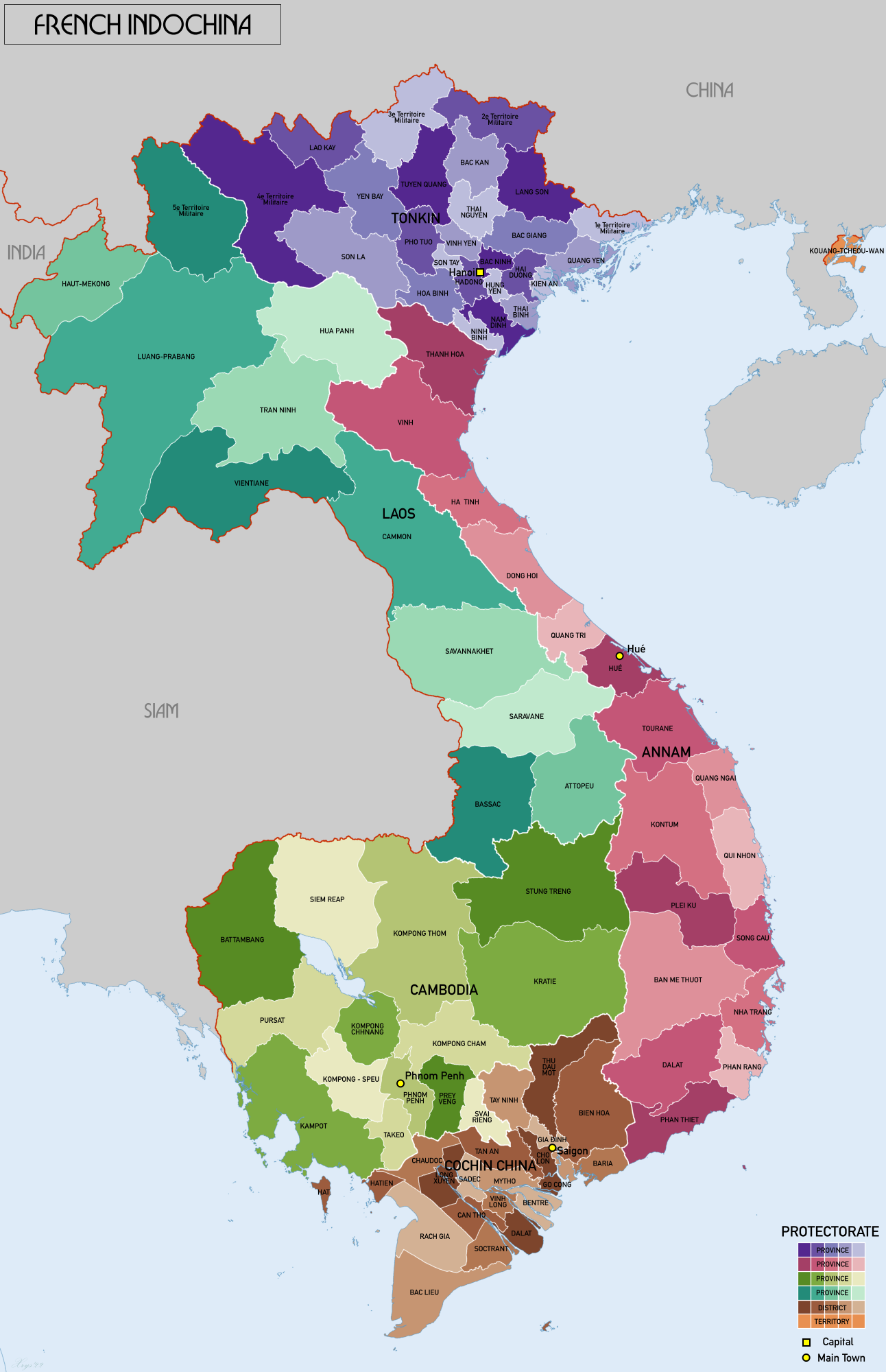
![[4]](https://commons.wikimedia.org/w/index.php?title=File:Map_of_Qing_dynasty_18c.svg&diff=prev&oldid=572674157)
![[5]](https://commons.wikimedia.org/w/index.php?title=File:Map_of_Qing_dynasty_18c.svg&diff=prev&oldid=637122489)
![[7]](https://commons.wikimedia.org/w/index.php?title=Special:GlobalUsage&offset=&limit=500&target=Meemu+Atoll.png)
Article(s): Various and many, mainly related to politics, anthropology, linguistics, archeology, history and political ideologies
- Request
The map I need shows 5 territories in different colors. The map should be a flat world map that people can easily modify, like the ones usually found on Wikipedia. Several copies of the map can be exported, one without the borders of the countries of the world, one with the borders of the countries of the world and one in orthographic projection. If you don't have time, the simple one without the borders of the countries of the world will suffice. Attention, one of the territories represented on the map is itself divided by several borders.
1) "Japan" (bc002d color) :
Includes all the current Japan (main islands, islets, Nansei archipelago, etc.), Senkaku, the Kuril Islands, Sakhalin Island and the Kamchatka Peninsula.
2) 2) "Korea" (0055ff) :
Includes both Koreas (everything south of the Tumen River) and Jiandao (Gando).
3) "Turkic-Mongolic-Tungusic" :
You should draw the in this order for not getting in trouble.
3.1) "Western Turkic" (0099dd) :
Include Turkey, Northern Cyprus, Iranian Azerbaijan (West Azerbaijan, East Azerbaijan and Ardabil provinces of Iran), Azerbaijan.
3.2) "Mongolia" (0000ff) :
Includes all of Outer Mongolia and all of Inner Mongolia, including territories that seem to have been cut off from it such as the Josutu League or the Southern Chahar region in northern Hebei. Include everything located between the southern border of Inner Mongolia and the Great Wall of China as well. The part of Russia surrounded by Amur river, Outer Mongolia, Yenisei river-Angara river, Baikal lake, Lena river-Aldan river, Stanovoi range and Okhotsk sea is also included as "Mongolia".
3.3) "Manchuria" (ffcc22) :
Everything surrounded by "Mongolia" you drawn at the west, Amur river flowing to Sakhalin in the North, the sea at the east, Korea at the south and then use the Great Wall as a border with China until it reaches the Mongolian territory you drew that also use the Great Wall as a border with China. In China, it mainly covers the Jilin, Heilongjiang and Liaoning as well as some parts of others provinces like Hebei that are located at the North of the Great Wall.
3.4) "Northern, Southern and Eastern Turkic" (0099dd, same than Western Turkic) :
3.4.1) Territory :
Central Asia including Tajikistan, Wakhan Corridor in Afghanistan and in Russia : all of the lands located at the East of Tobol-Irtysh-Ob in Siberia that do not belong to "Mongolia", "Manchuria" or "Japan" until the Bering Strait. In China, include everything located in the North of the Tibetan Plateau and the Great Wall that you didn’t gave to "Mongolia" and "Manchuria", mainly it’s northern Gansu and Xinjiang.
3.4.2) Borders :
As you can see, this territory should be divided in 3 : Eastern, Northern and Southern. The border used between the Eastern "Turkic" part and Northern "Turkic" part is the Yenisei river. The border between the Southern "Turkic" and Northern "Turkic" is composed of : • In Turkmenistan, any natural border between the Caspian sea and the Aral sea. • The Aral sea itself crossed by the border in its middle. • The Syr-Daria river. • Any natural link between Syr-Daria river and the Altishahr-Dzungaria border. • In Xinjiang, the natural border between Dzungaria and Altishahr (Tarim Basin). Everything further, such as the "Turkic" part in Gansu located in the North of the Great Wall and finally reaching "Mongolia", belong to "North Turkic".
4) Other (light grey) :
• Turkmen-Uzbek little regions in the North of Afghanistan, Afghanistan.
• Zanjan province, Iran
• Gagauzia, Moldavia
• Astrakhan Oblast, Russia
• Bashkortostan, Russia
• Chuvashia, Russia
• Crimea, Ukraine/Russia
• Daghestan, Russia
• Kabardino-Balkaria, Russia
• Karachayevo-Cherkessia, Russia
• Tatarstan, Russia
• Regions of Russia located between Kazakhstan and Bashkortostan-Chuvashia-Tatarstan, Russia.
• The area between the Ural Mountains (historical border between Europe and Asia) and the Tobol-Irtysh-Ob, Russia. — Preceding unsigned comment added by EpicDiscoMarmot (talk • contribs) 21:49, 20 March 2022 (UTC)
- Graphist opinion(s)
Who made this request?
It's extensive and would need you being involved in the work all the way. So please sign this and ping me and I can help you, thanks. --please ping me-- Goran tek-en (talk) 14:22, 23 November 2022 (UTC)
- @Goran tek-en: , it was made by user "EpicDiscoMarmot" back on 21:49, 20 March 2022. This is their only edit so it is entirely possible that they have abandoned their account or forgot their password. Anyhow, hopefully they'll see this ping and (finally) respond. --Donald Trung 『徵國單』 (No Fake News 💬) (WikiProject Numismatics 💴) (Articles 📚) 19:12, 11 April 2023 (UTC)