File:Bödele Bregenzerwald Panorama.jpg
Jump to navigation
Jump to search
Size of this preview: 800 × 231 pixels. Other resolutions: 320 × 92 pixels | 640 × 185 pixels | 1,024 × 296 pixels | 1,280 × 370 pixels | 6,956 × 2,010 pixels.
Original file (6,956 × 2,010 pixels, file size: 2.4 MB, MIME type: image/jpeg)
Captions
Captions
Add a one-line explanation of what this file represents
|
| Description |
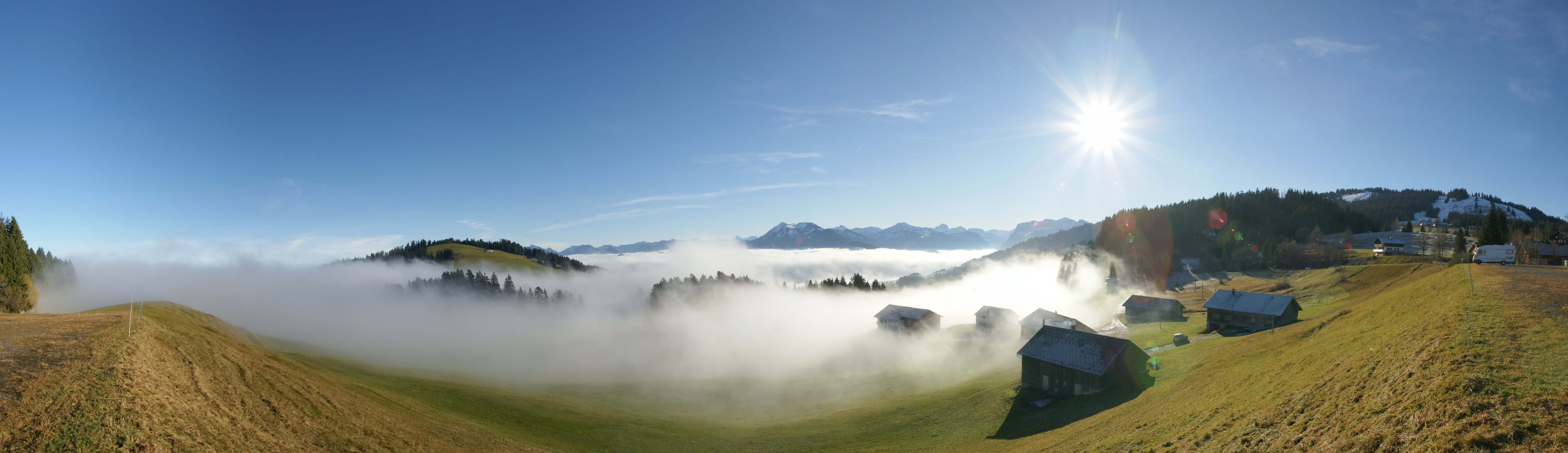
Deutsch: 180° Panorama am Bödele, gelegen zwischen Dornbirn und Schwarzenberg, Vorarlberg, Österreich. Die 2 Bergspitzen in der Bildmitte sind die Winterstaude 1877m und rechts der Hohe Ifen 2230m. Das Bergmassiv unter der Sonne ist die Nordflanke der Kanisfluh. Am rechten Bildrand zu sehen das Skigebiet Bödele mit dem Hochälpelekopf 1464m.
English: 180 ° panorama at Bödele, located between Dornbirn and Schwarzenberg, Vorarlberg, Austria. The 2 peaks in the middle are the winter Perennial 1877m and the right of the High Ifen 2230m. The mountain range under the sun is the northern flank of Kanisfluh. On the right screen to see the ski area with the Bödele Hochälpelekopf 1464m.
Français : Vue panoramique à 180 ° depuis Bödele, un village entre Dornbirn et Schwarzenberg, dans le Vorarlberg, en Autriche. Les deux sommets visibles à l'horizon au centre sont le Winterstaude (1877) et le Hoher Ifen (2230). La chaine de montagne juste sous le soleil correspond au flanc nord du Kanisfluh. Tout à droite de la photo on voit le domaine skiable culminant au Bödele Hochälpelekopf à 1464m.
|
||
| Date | |||
| Source | Own work | ||
| Author | böhringer friedrich | ||
| Permission (Reusing this file) |
I, the copyright holder of this work, hereby publish it under the following license: This file is licensed under the Creative Commons Attribution-Share Alike 2.5 Generic license.
|
||
| Other versions |
|

This Photo was taken by Böhringer Friedrich.
|
Feel free to use my photos, but please mention me as the author and if you want send me a message. or (rufre@lenz-nenning.at) |
| Camera location | | View this and other nearby images on: OpenStreetMap |
|---|
| Annotations | This image is annotated: View the annotations at Commons |
File history
Click on a date/time to view the file as it appeared at that time.
| Date/Time | Thumbnail | Dimensions | User | Comment | |
|---|---|---|---|---|---|
| current | 19:32, 21 November 2008 | 6,956 × 2,010 (2.4 MB) | Böhringer (talk | contribs) | {{Information |Description= {{de| 180° Panorama am Bödele, gelegen zwischen Dornbirn und Schwarzenberg. Die 2 Bergspitzen in der Bildmitte sind die [[:de:Winterstaude|Winterstaude 1877m | |
| 10:34, 17 November 2008 | 6,956 × 2,010 (8.29 MB) | Böhringer (talk | contribs) | {{Information |Description= {{de| 180° Panorama am Bödele, gelegen zwischen Dornbirn und Schwarzenberg.}} |Source= own work |Date= 2008-11-16 |Author= [[User:Böhringer|böhringer fried |
You cannot overwrite this file.
File usage on Commons
The following 48 pages use this file:
- Bregenz Forest
- Bödele
- Exzellente Bilder aus Vorarlberg
- Fog
- Vorarlberg
- User:Böhringer
- User:Böhringer/Archive 1
- User:Böhringer/Profile
- User:Jklamo/POTY/Panoramas
- User:Miya/POTY/Panoramas2008
- User:Notafish
- User:Notafish/Worthy of note by others
- User:The High Fin Sperm Whale/Favourites
- Commons:Conhece os nossos fotógrafos
- Commons:Conoce a nuestros fotógrafos
- Commons:Descobrètz nòstres fotografes
- Commons:Découvrez nos photographes
- Commons:Featured picture candidates/Image:Bödele Bregenzerwald Panorama.jpg
- Commons:Featured picture candidates/Log/December 2008
- Commons:Featured pictures/Places/Natural/Austria
- Commons:Featured pictures/Places/Panoramas
- Commons:Featured pictures/chronological/2008-B
- Commons:Fotoğrafçılarımızla tanışın
- Commons:Meet our photographers
- Commons:Meet our photographers/People
- Commons:Picture of the Year/2008/Galleries/All
- Commons:Picture of the Year/2008/Galleries/Panoramas 2
- Commons:Picture of the Year/2008/Results/Round 1/Gallery/All
- Commons:Picture of the Year/2008/Results/Round 1/Gallery/Panoramas
- Commons:Picture of the Year 2008/File:Bödele Bregenzerwald Panorama.jpg
- Commons:Poznaj naszych fotografów
- Commons:Quality images/Subject/Places/Natural structures/Panorama/Archive 2008 to 2015
- Commons:Quality images candidates/Archives November 2008
- Commons:Scopri i nostri fotografi
- Commons:Scummigghia ê nostri fotògrafi
- Commons:Temui jurugambar kami
- Commons:Unsere Fotografen stellen sich vor
- Commons:Unseri Fotografe stelle sich vor
- Commons:Upoznajte naše fotografe
- Commons:Биздин фотографтар менен таанышыңыз
- Commons:Запознајте ги нашите фотографи
- Commons:Знакомьтесь с нашими фотографами
- Commons:قابل مصورينا
- Commons:私達の写真家をご紹介します
- Commons:结识我们的摄影师
- Commons:结识我们的摄影师/人们
- Commons:우리들의 사진가를 만나보세요
- File:Bödele Nebel.jpg
File usage on other wikis
The following other wikis use this file:
- Usage on bs.wikipedia.org
- Usage on de.wikipedia.org
- Usage on en.wikipedia.org
- Usage on es.wikipedia.org
- Usage on es.wikivoyage.org
- Usage on et.wikipedia.org
- Usage on fr.wikipedia.org
- Usage on hy.wikipedia.org
- Usage on mk.wikipedia.org
- Usage on nl.wikipedia.org
- Usage on pl.wikipedia.org
- Usage on sq.wikipedia.org
- Usage on sv.wikipedia.org
- Usage on uk.wikipedia.org
- Usage on vi.wikipedia.org