File:Corps of Engineers to raise Dahla Dam, provide water essential to southern Afghanistan 140118-A-DT641-204.jpg
Original file (3,068 × 2,041 pixels, file size: 4.66 MB, MIME type: image/jpeg)
Captions
Summary
[edit]DescriptionCorps of Engineers to raise Dahla Dam, provide water essential to southern Afghanistan 140118-A-DT641-204.jpg |
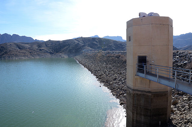
English: It is estimated about two million people will be affected by a project being overseen by the U.S. Army Corps of Engineers to raise the earthen Dahla Dam by 25 feet, boosting reservoir holding capacity and increasing water for irrigation and consumption. The reservoir was created with the 1952 completion of the U.S.-funded, dam on the Arghandab River in Helmand province. It originally held 83 billion gallons of water, just under 1/100th the volume of Lake Mead along the U.S.’s Colorado River. Three decades of war and neglect left the dam, and its network of irrigating canals across Kandahar province, silted and in ruins. (U.S. Army Corps of Engineers photo by Bill Dowell/Released) |
|||
Date | Taken on 18 January 2014 | |||
Source | https://www.dvidshub.net/image/1236820 | |||
Author | William Dowell | |||
Location InfoField | KANDAHAR, AF | |||
VIRIN InfoField |
|
|||
Posted InfoField | 10 April 2014, 05:29 | |||
Archive link InfoField | archive copy at the Wayback Machine |
Licensing
[edit]Public domainPublic domainfalsefalse |
This file is a work of a U.S. Army soldier or employee, taken or made as part of that person's official duties. As a work of the U.S. federal government, it is in the public domain in the United States.
العربية ∙ বাংলা ∙ català ∙ čeština ∙ Deutsch ∙ English ∙ español ∙ eesti ∙ فارسی ∙ suomi ∙ français ∙ hrvatski ∙ magyar ∙ Bahasa Indonesia ∙ italiano ∙ 日本語 ∙ 한국어 ∙ lietuvių ∙ македонски ∙ മലയാളം ∙ မြန်မာဘာသာ ∙ Nederlands ∙ polski ∙ português ∙ русский ∙ sicilianu ∙ српски / srpski ∙ Türkçe ∙ українська ∙ Tiếng Việt ∙ 中文(简体) ∙ 中文(繁體) ∙ +/− |
File history
Click on a date/time to view the file as it appeared at that time.
Date/Time | Thumbnail | Dimensions | User | Comment | |
---|---|---|---|---|---|
current | 19:37, 29 April 2015 | 3,068 × 2,041 (4.66 MB) | Fæ (talk | contribs) | == {{int:filedesc}} == {{milim | description = {{en|1=It is estimated about two million people will be affected by a project being overseen by the U.S. Army Corps of Engineers to raise the earthen Dahla Dam by 25 feet, boosting reservoir holding capac... |
You cannot overwrite this file.
File usage on Commons
There are no pages that use this file.
File usage on other wikis
The following other wikis use this file:
- Usage on en.wikipedia.org
- Usage on fa.wikipedia.org
Metadata
This file contains additional information such as Exif metadata which may have been added by the digital camera, scanner, or software program used to create or digitize it. If the file has been modified from its original state, some details such as the timestamp may not fully reflect those of the original file. The timestamp is only as accurate as the clock in the camera, and it may be completely wrong.
Camera manufacturer | NIKON CORPORATION |
---|---|
Camera model | NIKON D4 |
Author | Dowell |
Exposure time | 1/400 sec (0.0025) |
F-number | f/10 |
ISO speed rating | 400 |
Date and time of data generation | 06:10, 16 January 2014 |
Lens focal length | 18 mm |
Short title |
|
Image title |
|
Headline | Corps of Engineers to raise Dahla Dam, provide water essential to southern Afghanistan |
City shown | Kandahar |
Credit/Provider | U.S. Army |
Source | Digital |
Copyright holder | Public Domain |
Width | 3,200 px |
Height | 2,128 px |
Bits per component |
|
Pixel composition | RGB |
Orientation | Normal |
Number of components | 3 |
Horizontal resolution | 300 dpi |
Vertical resolution | 300 dpi |
Software used | Adobe Photoshop CS5.1 Windows |
File change date and time | 16:02, 8 April 2014 |
Y and C positioning | Co-sited |
Exposure Program | Normal program |
Exif version | 2.3 |
Date and time of digitizing | 06:10, 16 January 2014 |
Meaning of each component |
|
Image compression mode | 4 |
APEX shutter speed | 8.643856 |
APEX aperture | 6.643856 |
APEX exposure bias | 0 |
Maximum land aperture | 3.6 APEX (f/3.48) |
Subject distance | 794 meters |
Metering mode | Spot |
Light source | Unknown |
Flash | Flash did not fire |
DateTime subseconds | 80 |
DateTimeOriginal subseconds | 80 |
DateTimeDigitized subseconds | 80 |
Supported Flashpix version | 1 |
Color space | sRGB |
Sensing method | One-chip color area sensor |
File source | Digital still camera |
Scene type | A directly photographed image |
Custom image processing | Normal process |
Exposure mode | Auto exposure |
White balance | Auto white balance |
Digital zoom ratio | 1.53 |
Focal length in 35 mm film | 27 mm |
Scene capture type | Standard |
Scene control | Low gain up |
Contrast | Normal |
Saturation | Normal |
Sharpness | Normal |
Subject distance range | Unknown |
GPS tag version | 2.3.0.0 |
Lens used | 18.0-200.0 mm f/3.5-5.6 |
Rating (out of 5) | 3 |
Date metadata was last modified | 20:32, 8 April 2014 |
Writer | Dowell |
Unique ID of original document | xmp.did:2056526BEC80E3119877B0590BF6FB97 |
Keywords |
|
Code for country shown | AF |
Special instructions | Released
William Dowell U.S. Army Corps of Engineers william.dowell@hurlburt.af.mil via DVIDS |
Original transmission location code | CENTCOM |
Country shown | Afghanistan |