File:Kosovo map-en.svg
Jump to navigation
Jump to search

Size of this PNG preview of this SVG file: 582 × 599 pixels. Other resolutions: 233 × 240 pixels | 466 × 480 pixels | 746 × 768 pixels | 994 × 1,024 pixels | 1,989 × 2,048 pixels | 1,777 × 1,830 pixels.
Original file (SVG file, nominally 1,777 × 1,830 pixels, file size: 3.81 MB)
Captions
Captions
Add a one-line explanation of what this file represents
Summary[edit]
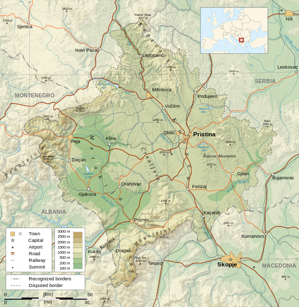
| Description |
Čeština: Mapa Kosova. Dansk: Kort over Kosovo. Deutsch: Karte des Kosovo. English: Map of the Kosovo. Español: Mapa de Kosovo. Français : Carte du Kosovo, en anglais. Italiano: Mappa del Kosovo. Magyar: Koszovó térképe albán és szerb helységnevekkel. Polski: Mapa Kosowa. Română: Harta provinciei Kosovo Svenska: Karta över Kosovo, engelskspråkig. Türkçe: Kosova haritası. Македонски: Карта на Косово на англиски. Русский: Карта Косово, на английском. Українська: Карта Косово 日本語: コソボの地図。 |
||||||
| Date | |||||||
| Source |
Own work. Sources :
Software used :
Other data :
|
||||||
| Creator | |||||||
| Georeferencing | If inappropriate please set warp_status = skip to hide. | ||||||
| Other versions |
[] | ||||||
| Attribution (required by the license) | © Sémhur / Wikimedia Commons / | ||||||
| Assessments |
|
||||||
| SVG | W3C-validity not checked.
|
||||||
| Graphic Lab |


| Camera location | | View this and other nearby images on: OpenStreetMap |
|---|
Licensing[edit]
I, the copyright holder of this work, hereby publish it under the following licenses:
| Copyleft: This work of art is free; you can redistribute it and/or modify it according to terms of the Free Art License. You will find a specimen of this license on the Copyleft Attitude site as well as on other sites. |
This file is licensed under the Creative Commons Attribution-Share Alike 4.0 International, 3.0 Unported, 2.5 Generic, 2.0 Generic and 1.0 Generic license.
- You are free:
- to share – to copy, distribute and transmit the work
- to remix – to adapt the work
- Under the following conditions:
- attribution – You must give appropriate credit, provide a link to the license, and indicate if changes were made. You may do so in any reasonable manner, but not in any way that suggests the licensor endorses you or your use.
- share alike – If you remix, transform, or build upon the material, you must distribute your contributions under the same or compatible license as the original.
You may select the license of your choice.
File history
Click on a date/time to view the file as it appeared at that time.
| Date/Time | Thumbnail | Dimensions | User | Comment | |
|---|---|---|---|---|---|
| current | 14:35, 21 September 2023 | | 1,777 × 1,830 (3.81 MB) | Socialdilema (talk | contribs) | File uploaded using svgtranslate tool (https://svgtranslate.toolforge.org/). Added translation for ca. |
| 18:41, 12 May 2021 |  | 1,777 × 1,830 (3.74 MB) | Uniacademic (talk | contribs) | Same as the previous edit. | |
| 18:28, 12 May 2021 |  | 1,777 × 1,830 (3.74 MB) | Uniacademic (talk | contribs) | Updated the names of cities in cases where WP:COMMONNAME has changed since 2008. | |
| 09:14, 5 March 2008 |  | 1,777 × 1,830 (3.75 MB) | Sémhur (talk | contribs) | Added borders, with keys (recognized - disputed) | |
| 09:16, 4 March 2008 |  | 1,777 × 1,830 (3.74 MB) | Sémhur (talk | contribs) | Remove Kosovo boundaries to neutralize the map, + labels more readable | |
| 14:45, 3 March 2008 |  | 1,777 × 1,830 (3.74 MB) | Sémhur (talk | contribs) | Correcting few labels | |
| 19:15, 28 February 2008 |  | 1,777 × 1,830 (3.74 MB) | Sémhur (talk | contribs) | minor changes | |
| 11:37, 26 February 2008 |  | 1,777 × 1,830 (3.74 MB) | Sémhur (talk | contribs) | == Description == {{Information |Description= {{en| Map of the Kosovo.}} {{fr| Carte du Kosovo, en anglais.}} |Source=Own work. {{clr}} Sources : * Topographic background : [http://www2.jpl.nasa.gov/srtm NASA Shuttle Radar To |
You cannot overwrite this file.
File usage on Commons
The following 21 pages use this file:
- Atlas of Kosovo
- Wikimedia Conference Japan 2009/Commons写真展
- User:Giorgi Balakhadze/Gallery
- User:JoKalliauer/SVG test suites/Featured details
- User:Magog the Ogre/Multilingual legend/2021 May 11-20
- User:Magog the Ogre/Multilingual legend/2023 September 21-25
- User:Miya/Introduction
- User:Miya/POTY/Diagrams2008
- User talk:Sémhur/Archives/2007-2008
- Commons:Featured picture candidates/Image:Kosovo map-en.svg
- Commons:Featured picture candidates/Image:Kosovo map-en.svg 1
- Commons:Featured picture candidates/Log/March 2008
- Commons:Featured pictures/Non-photographic media/Maps
- Commons:Featured pictures/chronological/2008-A
- Commons:Picture of the Year/2008/Galleries/All
- Commons:Picture of the Year/2008/Galleries/Diagrams
- Commons:Picture of the Year/2008/Results/Round 1/Gallery/All
- Commons:Picture of the Year/2008/Results/Round 1/Gallery/Diagrams
- Commons:Picture of the Year 2008/File:Kosovo map-en.svg
- File:Kosovo map-cs.svg
- File:Republic of KOSOVO.png (file redirect)
File usage on other wikis
The following other wikis use this file:
- Usage on af.wikipedia.org
- Usage on ar.wikipedia.org
- Usage on az.wikipedia.org
- Usage on bcl.wikipedia.org
- Usage on be-tarask.wikipedia.org
- Usage on bg.wikipedia.org
- Usage on de.wikipedia.org
- Usage on de.wikibooks.org
- Usage on en.wikipedia.org
- Usage on es.wikipedia.org
- Usage on fa.wikipedia.org
- Usage on fi.wikipedia.org
- Usage on fr.wikipedia.org
- Usage on fr.wikinews.org
- Usage on ga.wikipedia.org
- Usage on gl.wikipedia.org
- Usage on gv.wikipedia.org
- Usage on hy.wikipedia.org
- Usage on is.wikipedia.org
- Usage on ko.wikipedia.org
- Usage on lt.wikipedia.org
- Usage on mg.wikipedia.org
- Usage on ml.wikipedia.org
- Usage on mr.wikipedia.org
- Usage on mzn.wikipedia.org
- Usage on nn.wikipedia.org
- Usage on no.wikipedia.org
View more global usage of this file.