File:Magellan Elcano Circumnavigation-es.svg
Jump to navigation
Jump to search

Size of this PNG preview of this SVG file: 800 × 406 pixels. Other resolutions: 320 × 162 pixels | 640 × 325 pixels | 1,024 × 519 pixels | 1,280 × 649 pixels | 2,560 × 1,298 pixels | 2,246 × 1,139 pixels.
Original file (SVG file, nominally 2,246 × 1,139 pixels, file size: 1.02 MB)
Captions
Captions
Add a one-line explanation of what this file represents
Summary[edit]
| Description |
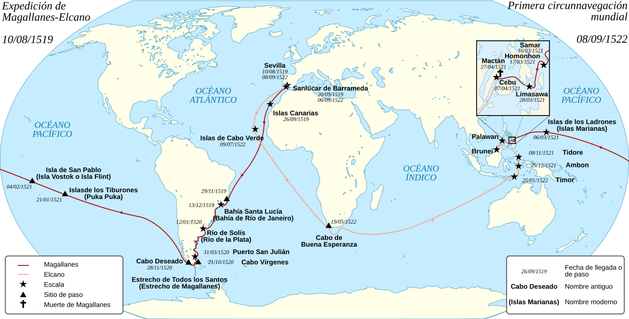
English: Spanish map of the first world circumnavigation of Ferdinand de Magellan and Juan Sebastián Elcano, from 1519 to 1522. Español: Mapa de la primera circunnavegación del mundo, por Fernando de Magallanes y Juan Sebastián Elcano, de 1519 a 1522. Français : Carte en espagnol de la première circumnavigation du monde, par Ferdinand de Magellan et Juan Sebastián Elcano, de 1519 à 1522. |
||||
| Date | (UTC) | ||||
| Source | Magellan_Elcano_Circumnavigation-fr.svg | ||||
| Author |
|
||||
| Other versions |
Magellan_Elcano_Circumnavigation-fr.svg: français | ||||
| SVG | W3C-validity not checked.
|

Licensing[edit]
I, the copyright holder of this work, hereby publish it under the following licenses:
This file is licensed under the Creative Commons Attribution-Share Alike 3.0 Unported, 2.5 Generic, 2.0 Generic and 1.0 Generic license.
- You are free:
- to share – to copy, distribute and transmit the work
- to remix – to adapt the work
- Under the following conditions:
- attribution – You must give appropriate credit, provide a link to the license, and indicate if changes were made. You may do so in any reasonable manner, but not in any way that suggests the licensor endorses you or your use.
- share alike – If you remix, transform, or build upon the material, you must distribute your contributions under the same or compatible license as the original.

|
Permission is granted to copy, distribute and/or modify this document under the terms of the GNU Free Documentation License, Version 1.2 or any later version published by the Free Software Foundation; with no Invariant Sections, no Front-Cover Texts, and no Back-Cover Texts. A copy of the license is included in the section entitled GNU Free Documentation License. |
You may select the license of your choice.
Original upload log[edit]
This image is a derivative work of the following images:
- File:Magellan_Elcano_Circumnavigation-fr.svg licensed with Cc-by-sa-3.0,2.5,2.0,1.0, GFDL
- 2008-03-02T15:16:17Z Sémhur 2246x1139 (224858 Bytes) Correction d'un texte
- 2008-03-01T16:18:00Z Sémhur 2246x1139 (224612 Bytes) {{Information |Description= {{en|French map of the first world [[:en:Circumnavigation|circumnavigation]] of [[:en:Ferdinand de Magellan|Ferdinand de Magellan]] and [[:en:Juan Sebastián Elcano|Juan Sebastián Elcano]], from 1
Uploaded with derivativeFX
| Annotations | This image is annotated: View the annotations at Commons |
File history
Click on a date/time to view the file as it appeared at that time.
| Date/Time | Thumbnail | Dimensions | User | Comment | |
|---|---|---|---|---|---|
| current | 10:42, 9 December 2017 | | 2,246 × 1,139 (1.02 MB) | Rowanwindwhistler (talk | contribs) | Fake text added. Colours from https://en.wikipedia.org/wiki/Wikipedia:WikiProject_Maps/Conventions |
| 19:44, 21 October 2013 |  | 2,246 × 1,139 (176 KB) | CarlosVdeHabsburgo (talk | contribs) | Adding Seville | |
| 18:21, 3 January 2013 |  | 2,246 × 1,139 (175 KB) | Sémhur (talk | contribs) | removing Seville ; standard colours | |
| 17:17, 14 December 2012 |  | 2,246 × 1,139 (176 KB) | Sémhur (talk | contribs) | Adding Sevilla | |
| 20:56, 19 October 2011 |  | 2,246 × 1,139 (207 KB) | Sémhur (talk | contribs) | background centered | |
| 17:21, 17 May 2011 |  | 2,246 × 1,139 (218 KB) | Armando-Martin (talk | contribs) | {{Information |Description={{en|French map of the first world circumnavigation of Ferdinand de Magellan and Juan Sebastián Elcano, from 1519 to 1522.}} {{fr|Carte de l |
You cannot overwrite this file.
File usage on Commons
The following 7 pages use this file:
- Armada Española
- User:Chumwa/OgreBot/Potential transport maps/2017 December 1-10
- User:Chumwa/OgreBot/Transport Maps/2017 December 1-10
- User:Chumwa/OgreBot/Travel and communication maps/2017 December 1-10
- User:OgreBot/Watercraft/2017 December 9
- File:Magellan Elcano Circumnavigation-de.svg
- Category:Magellan-Elcano circumnavigation
File usage on other wikis
The following other wikis use this file:
- Usage on ast.wikipedia.org
- Usage on ca.wikipedia.org
- Usage on es.wikipedia.org
- Juan Sebastián Elcano
- Fernando de Magallanes
- Armada española
- Antonio Pigafetta
- Historia de Filipinas
- Victoria (nao)
- Circunnavegación
- Historia de la Armada española
- Sanlúcar de Barrameda
- Expedición de Magallanes-Elcano
- Imperio español en Asia y Oceanía
- Exploración geográfica
- Historia moderna de España
- Anexo:Patrimonio de la Humanidad en Portugal
- Primeros viajes de exploración científica
- Cuarto viaje de Colón
- Anexo:Programa memoria del mundo en España
- Wikipedia:PESCAR/2020
- Wikipedia:PESCAR/2021
- Usuario:Jialxv/Plantillas/PESCAR
- Usage on eu.wikipedia.org
- Usage on gl.wikipedia.org
- Usage on it.wikipedia.org
- Usage on la.wikipedia.org
- Usage on mt.wikipedia.org
- Usage on sh.wikipedia.org
- Usage on www.wikidata.org
- Usage on zh.wikipedia.org