File:New York. NYPL434684.tiff
Jump to navigation
Jump to search

Size of this JPG preview of this TIF file: 666 × 600 pixels. Other resolutions: 266 × 240 pixels | 533 × 480 pixels | 853 × 768 pixels | 1,137 × 1,024 pixels | 2,274 × 2,048 pixels | 6,328 × 5,700 pixels.
Original file (6,328 × 5,700 pixels, file size: 64.72 MB, MIME type: image/tiff)
Captions
Captions
Add a one-line explanation of what this file represents
Summary[edit]
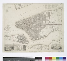
| Description | New York.; Maps of New York City and State / New York City / Manhattan | |||||||||||||||||||||||
| Notes | Covers Manhattan up to 42nd St., and parts of Jersey City, Brooklyn, and Williamsburg. ''Note 2.'') In bottom margin: [?]94. ''Note 3.'') Includes index to public buildings and ill. of City Hall and of Broadway from the park. ''Note 4.'') National Endowment for the Humanities Grant for Access to Early Maps of the Middle Atlantic Seaboard. ''Note 5.'') Oriented with north to the right. ''Note 6.'') Probably extracted from Society for the Diffusion of Useful Knowledge, Maps, 1844, v. 2. | |||||||||||||||||||||||
| Item physical description | 1 map : hand col. ; 31 x 38 cm. | |||||||||||||||||||||||
| Catalogue call number | Map Div. 01-1793 [Filed with N.Y.C., 1840, as originally cataloged in NYPL. Dictionary catalog of the Map Division] | |||||||||||||||||||||||
| Standard reference | Haskell, D.C. Manhattan maps, 841 | |||||||||||||||||||||||
| Date | circa 1844 | |||||||||||||||||||||||
| Source |
http://digitalgallery.nypl.org/nypldigital/dgkeysearchdetail.cfm?imageID=434684
|
|||||||||||||||||||||||
| Author | Society for the Diffusion of Useful Knowledge (Great Britain) -- Associated name | |||||||||||||||||||||||
| Permission (Reusing this file) |
From The Lionel Pincus and Princess Firyal Map Division. http://maps.nypl.org
|
|||||||||||||||||||||||
| Location | Stephen A. Schwarzman Building / The Lionel Pincus and Princess Firyal Map Division | |||||||||||||||||||||||
| Digital item published | 2-28-2005; updated 5-16-2012 | |||||||||||||||||||||||
| Digital ID | 434684 | |||||||||||||||||||||||

The making of this file was supported by Wikimedia UK.
To see other files made with the support of Wikimedia UK, please see the category Supported by Wikimedia UK.
|
File history
Click on a date/time to view the file as it appeared at that time.
| Date/Time | Thumbnail | Dimensions | User | Comment | |
|---|---|---|---|---|---|
| current | 21:59, 21 February 2016 |  | 6,328 × 5,700 (64.72 MB) | Finavon (talk | contribs) | rotated |
| 09:58, 2 May 2014 |  | 5,700 × 6,328 (103.2 MB) | Fæ (talk | contribs) | GWToolset:: Creating mediafile for Fæ. Tranche 3 11591-16518 @ 2 May, 06:47 BST |
You cannot overwrite this file.
File usage on Commons
There are no pages that use this file.