File:Ostfriesland de.svg
Jump to navigation
Jump to search

Size of this PNG preview of this SVG file: 696 × 599 pixels. Other resolutions: 279 × 240 pixels | 557 × 480 pixels | 892 × 768 pixels | 1,189 × 1,024 pixels | 2,378 × 2,048 pixels | 756 × 651 pixels.
Original file (SVG file, nominally 756 × 651 pixels, file size: 382 KB)
Captions
Captions
Add a one-line explanation of what this file represents
Summary[edit]
| Description |
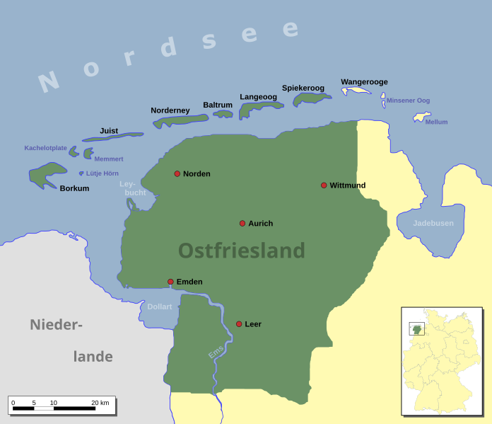
English: East Frisia Deutsch: Ostfriesland Français : Carte de la Frise Orientale |
||
| Date | |||
| Source | Self drawn; regional borderline from Ostfriesland karte.jpg by Anki64; the overwiew map is based on Karte Bundesrepublik Deutschland.svg by David Liuzzo. | ||
| Author | Enricopedia | ||
| Other versions |
|
||
| SVG development |
|


I, the copyright holder of this work, hereby publish it under the following license:
This file is licensed under the Creative Commons Attribution-Share Alike 2.5 Generic license.
- You are free:
- to share – to copy, distribute and transmit the work
- to remix – to adapt the work
- Under the following conditions:
- attribution – You must give appropriate credit, provide a link to the license, and indicate if changes were made. You may do so in any reasonable manner, but not in any way that suggests the licensor endorses you or your use.
- share alike – If you remix, transform, or build upon the material, you must distribute your contributions under the same or compatible license as the original.
File history
Click on a date/time to view the file as it appeared at that time.
| Date/Time | Thumbnail | Dimensions | User | Comment | |
|---|---|---|---|---|---|
| current | 19:16, 24 January 2009 | | 756 × 651 (382 KB) | NordNordWest (talk | contribs) | Memmert, Kachelotplatte and Lütje Hörn green |
| 13:45, 26 January 2007 |  | 756 × 651 (382 KB) | Enricopedia (talk | contribs) | updated version | |
| 22:53, 18 January 2007 |  | 756 × 651 (377 KB) | Enricopedia (talk | contribs) | '''m''' typo | |
| 22:23, 18 January 2007 |  | 756 × 651 (377 KB) | Enricopedia (talk | contribs) | {{Information |Description={{en|en:East Frisia}}{{de|de:Ostfriesland}} |Source=self drawn, regional border are from Image:Ostfriesland_karte.jpg made by Anki64, the overwiew map is based on [[:Image:Karte_Bundesrepublik_ |
You cannot overwrite this file.
File usage on Commons
The following 7 pages use this file:
File usage on other wikis
The following other wikis use this file:
- Usage on af.wikipedia.org
- Usage on ar.wikipedia.org
- Usage on be.wikipedia.org
- Usage on ca.wikipedia.org
- Usage on cs.wikipedia.org
- Usage on da.wikipedia.org
- Usage on de.wikipedia.org
- Wikipedia:Kartenwerkstatt/Archiv/2007-01
- Wikipedia:WikiProjekt Ostfriesland/Kartenzimmer
- Diskussion:Ostfriesland/Archiv/1
- Wikipedia:Kartenwerkstatt/Archiv/2009-01
- Diskussion:Norderney/Archiv/1
- Niedersächsisches Landesarchiv (Abteilung Aurich)
- Benutzer Diskussion:Onno/Archiv 2008
- Wikipedia:Kartenwerkstatt/Archiv/2010-02
- Benutzer:Aeroid/List DE NI Immediate
- Usage on eo.wikipedia.org
- Usage on eu.wikipedia.org
- Usage on fr.wikipedia.org
- Usage on fy.wikipedia.org
- Usage on he.wikipedia.org
- Usage on hr.wikipedia.org
- Usage on is.wikipedia.org
- Usage on it.wikipedia.org
- Usage on no.wikipedia.org
- Usage on ru.wikipedia.org
- Usage on sv.wikipedia.org
- Usage on uk.wikipedia.org
- Usage on www.wikidata.org