File:Plan of a tract of land called Port Royal, covered by part of the city of Washington LOC 88693031.tif
Jump to navigation
Jump to search

Size of this JPG preview of this TIF file: 726 × 599 pixels. Other resolutions: 291 × 240 pixels | 582 × 480 pixels | 930 × 768 pixels | 1,240 × 1,024 pixels | 2,481 × 2,048 pixels | 8,525 × 7,038 pixels.
Original file (8,525 × 7,038 pixels, file size: 171.66 MB, MIME type: image/tiff)
Captions
Captions
Add a one-line explanation of what this file represents
Summary[edit]
| Description |
English: Cadastral map showing boundaries of Port Royal and its subsections in relation to the city street system. Covers area bounded by Q, 1st, F, and 18th streets N.W. Shows block numbers and dimensions. In lower margin: I certify that this plat is a true copy of the original in this office, Wm. Forsyth, Surveyor of the City of Washington. Pen-and-ink and watercolor. Torn, missing small sections along edges, laminated, and mounted on cloth backing. Available also through the Library of Congress Web site as a raster image. Vault DCP |
||
| Title | Plan of a tract of land called Port Royal, covered by part of the city of Washington | ||
| Shelf ID | G3852.P6G46 179- .D4 | ||
| Date | |||
| Source | https://www.loc.gov/item/88693031/ | ||
| Author | District Of Columbia. Office Of The Surveyor; Forsyth, William | ||
| Permission (Reusing this file) |
|
||
| Other versions |
|
||
| Location | United States · Washington D.C. · District Of Columbia · Washington · Port Royal | ||
| Part of | American Memory · Cities And Towns · Catalog · Geography And Map Division | ||
| Subject | Maps, Manuscript · Washington (D.C.) · Washington · United States · Maps · Early Works To 1800 · District Of Columbia · Port Royal (Washington, D.C.) · Port Royal · Real Property · Manuscript Maps |


Licensing[edit]
|
This is a faithful photographic reproduction of a two-dimensional, public domain work of art. The work of art itself is in the public domain for the following reason:
The official position taken by the Wikimedia Foundation is that "faithful reproductions of two-dimensional public domain works of art are public domain".
This photographic reproduction is therefore also considered to be in the public domain in the United States. In other jurisdictions, re-use of this content may be restricted; see Reuse of PD-Art photographs for details. | ||||
File history
Click on a date/time to view the file as it appeared at that time.
| Date/Time | Thumbnail | Dimensions | User | Comment | |
|---|---|---|---|---|---|
| current | 06:26, 10 May 2018 | 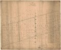 | 8,525 × 7,038 (171.66 MB) | Fæ (talk | contribs) | LOC Maps https://www.loc.gov/item/88693031/ #5262 |
You cannot overwrite this file.
File usage on Commons
The following page uses this file: