File:Mount Baker hazard map-fr.svg
Jump to navigation
Jump to search

Size of this PNG preview of this SVG file: 800 × 573 pixels. Other resolutions: 320 × 229 pixels | 640 × 459 pixels | 1,024 × 734 pixels | 1,280 × 917 pixels | 2,560 × 1,834 pixels | 4,712 × 3,376 pixels.
Original file (SVG file, nominally 4,712 × 3,376 pixels, file size: 4.24 MB)
Captions
Captions
Add a one-line explanation of what this file represents
Picture keys[edit]
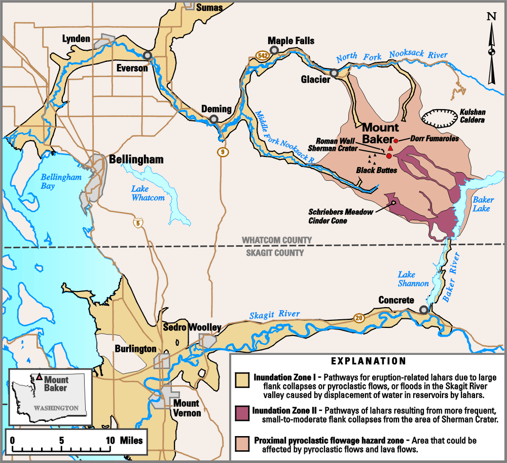
Zone inondable I : Passage des lahars causés par de larges effondrements des flancs du volcan ou de coulés de laves, ou des inondations de la rivière Skagit à cause d'éboulements de lahars dans les réservoirs d'eau
Zone inondable II : Passage de lahars provoqué par de fréquents et irréguliers éboulements dans la zone du cratère Sherman
Zone proche de coulées pyroclastiques fréquentes
Limites de comtés
Summary[edit]
| Description |
English: Hazard map in french around the Mount Baker, state of Washington, United States.
Français : Carte en français des risques liés au volcanisme du Mont Baker, état de Washington, États-Unis. |
| Date | |
| Source |
Own work.
Data sources :
Softwares used :
Others :
|
| Author | Pinpin |
| Other versions |
|


|
This SVG file contains embedded text that can be translated into your language, using any capable SVG editor, text editor or the SVG Translate tool. For more information see: About translating SVG files. |
This W3C-unspecified vector image was created with Inkscape .
Licensing[edit]
This image is in the public domain in the United States because it only contains materials that originally came from the United States Geological Survey, an agency of the United States Department of the Interior. For more information, see the official USGS copyright policy.
|
File history
Click on a date/time to view the file as it appeared at that time.
| Date/Time | Thumbnail | Dimensions | User | Comment | |
|---|---|---|---|---|---|
| current | 18:44, 11 February 2008 | | 4,712 × 3,376 (4.24 MB) | Pinpin (talk | contribs) | |
| 18:36, 11 February 2008 |  | 4,712 × 3,376 (4.24 MB) | Pinpin (talk | contribs) | == Picture keys == {{legend|#ffc1d65a|Zone inondable I : Passage des lahars causés par de larges effondrements des flancs du volcan ou de coulés de laves, ou des inondations de la rivière Skagit à cause d'éboulements de lahars dans les réservoirs d' |
You cannot overwrite this file.
File usage on Commons
The following 4 pages use this file:
File usage on other wikis
The following other wikis use this file:
- Usage on azb.wikipedia.org
- Usage on fr.wikipedia.org