File:Richat Structure - SRTM.jpg

Fichier d’origine (2 259 × 1 244 pixels, taille du fichier : 495 kio, type MIME : image/jpeg)
Légendes
Légendes
Description[modifier]
| Description |
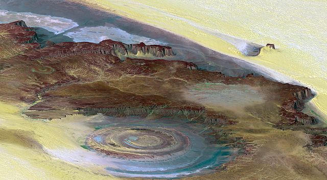
English: PIA04963: Richat Structure, Mauritania - This prominent circular feature, known as the Richat Structure, in the Sahara desert of Mauritania is often noted by astronauts because it forms a conspicuous 50-kilometer-wide (30-mile-wide) bull's-eye on the otherwise rather featureless expanse of the desert. Initially mistaken for a possible impact crater, it is now known to be an eroded circular anticline (structural dome) of layered sedimentary rocks.
Extensive sand dunes occur in this region and the interaction of bedrock topography, wind, and moving sand is evident in this scene. Note especially how the dune field ends abruptly short of the cliffs at the far right as wind from the northeast (lower right) apparently funnels around the cliff point, sweeping clean areas near the base of the cliff. Note also the small isolated peak within the dune field. That peak captures some sand on its windward side, but mostly deflects the wind and sand around its sides, creating a sand-barren streak that continues far downwind. This view was generated from a Landsat satellite image draped over an elevation model produced by the Shuttle Radar Topography Mission (SRTM). The view uses a 6-times vertical exaggeration to greatly enhance topographic expression. For vertical scale, note that the height of the mesa ridge in the back center of the view is about 285 meters (about 935 feet) tall. Colors of the scene were enhanced by use of a combination of visible and infrared bands, which helps to differentiate bedrock (browns), sand (yellow, some white), minor vegetation in drainage channels (green), and salty sediments (bluish whites). Some shading of the elevation model was included to further highlight the topographic features. Elevation data used in this image was acquired by the Shuttle Radar Topography Mission (SRTM) aboard the Space Shuttle Endeavour, launched on February 11, 2000. SRTM used the same radar instrument that comprised the Spaceborne Imaging Radar-C/X-Band Synthetic Aperture Radar (SIR-C/X-SAR) that flew twice on the Space Shuttle Endeavour in 1994. SRTM was designed to collect three-dimensional measurements of the Earth's surface. To collect the 3-D data, engineers added a 60-meter-long (200-foot) mast, installed additional C-band and X-band antennas, and improved tracking and navigation devices. The mission is a cooperative project between the National Aeronautics and Space Administration (NASA), the National Geospatial-Intelligence Agency (NGA) of the U.S. Department of Defense (DoD), and the German and Italian space agencies. It is managed by NASA's Jet Propulsion Laboratory, Pasadena, Calif., for NASA's Earth Science Enterprise, Washington, D.C.
|
| Date | (released) |
| Source | https://photojournal.jpl.nasa.gov/catalog/PIA04963 |
| Auteur | NASA/JPL/NIMA |
|
Cette image ou vidéo a été cataloguée par le Jet Propulsion Lab de la National Aeronautics and Space Administration (NASA) des États-Unis sous Photo ID : PIA04963.Ce bandeau n’indique rien sur le statut de l’œuvre au regard du droit d'auteur. Un bandeau de droit d’auteur est requis. Voir Commons:À propos des licences pour plus d’informations. Autres langues :
|
Conditions d’utilisation[modifier]
This image uses high-resolution digital topography data from NASA's Shuttle Radar Topography Mission (SRTM) at JPL-Caltech [1]. It is in the public domain in the United States.
|
 | |
Historique du fichier
Cliquer sur une date et heure pour voir le fichier tel qu'il était à ce moment-là.
| Date et heure | Vignette | Dimensions | Utilisateur | Commentaire | |
|---|---|---|---|---|---|
| actuel | 15 mai 2005 à 23:34 | | 2 259 × 1 244 (495 kio) | Atamari (d | contributions) | PIA04963: Richat Structure, Mauritania, Perspective View, Landsat Image over SRTM Elevation Source: http://photojournal.jpl.nasa.gov/catalog/PIA04963 {{GFDL}}{{SpaceShuttle}} Category:Mauritania\ |
Vous ne pouvez pas remplacer ce fichier.
Utilisations locales du fichier
Aucune page n’utilise ce fichier.
Utilisations du fichier sur d’autres wikis
Les autres wikis suivants utilisent ce fichier :
- Utilisation sur af.wikipedia.org
- Utilisation sur ba.wikipedia.org
- Utilisation sur be.wikipedia.org
- Utilisation sur bg.wikipedia.org
- Utilisation sur de.wikipedia.org
- Utilisation sur de.wikivoyage.org
- Utilisation sur en.wikipedia.org
- Richat Structure
- Location hypotheses of Atlantis
- Portal:Earth sciences
- Wikipedia:Featured pictures thumbs/05
- Wikipedia:Featured pictures/Space/Looking back
- Wikipedia:Featured picture candidates/November-2006
- Wikipedia:Featured picture candidates/Richat Structure
- Wikipedia:Wikipedia Signpost/2006-12-04/Features and admins
- Wikipedia:Wikipedia Signpost/2006-12-04/SPV
- Wikipedia:Picture of the day/March 2007
- Template:POTD/2007-03-19
- User talk:Debivort/Archive1
- Portal:Earth sciences/Selected pictures
- User:Passargea/Favourite pictures/Nature
- Remote sensing in geology
- Template:Did you know nominations/Remote sensing (geology)
- User:JPxG/SP 2006-2010
- Wikipedia:Wikipedia Signpost/Single/2006-12-04
- Utilisation sur es.wikipedia.org
- Utilisation sur fa.wikipedia.org
- Utilisation sur frp.wikipedia.org
- Utilisation sur fr.wikipedia.org
- Utilisation sur hu.wikipedia.org
- Utilisation sur hy.wikipedia.org
- Utilisation sur id.wikipedia.org
- Utilisation sur it.wikipedia.org
- Utilisation sur ja.wikipedia.org
- Utilisation sur ka.wikipedia.org
- Utilisation sur ko.wikipedia.org
- Utilisation sur nl.wikipedia.org
- Utilisation sur qu.wikipedia.org
- Utilisation sur ro.wikipedia.org
- Utilisation sur ru.wikipedia.org
- Utilisation sur sk.wikipedia.org
- Utilisation sur sr.wikipedia.org
Voir davantage sur l’utilisation globale de ce fichier.