File:World Köppen Map.jpg
(Redirected from File:World Koppen Map.jpg)

Size of this preview: 800 × 530 pixels. Other resolutions: 320 × 212 pixels | 640 × 424 pixels | 1,024 × 679 pixels | 1,280 × 848 pixels | 2,560 × 1,697 pixels | 4,231 × 2,804 pixels.
Original file (4,231 × 2,804 pixels, file size: 1.25 MB, MIME type: image/jpeg)
Captions
Captions
Add a one-line explanation of what this file represents

|
This meteorology image could be re-created using vector graphics as an SVG file. This has several advantages; see Commons:Media for cleanup for more information. If an SVG form of this image is available, please upload it and afterwards replace this template with
{{vector version available|new image name}}.
It is recommended to name the SVG file “World Köppen Map.svg”—then the template Vector version available (or Vva) does not need the new image name parameter. |


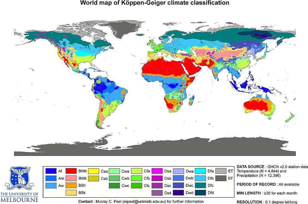
| Peel, M. C. and Finlayson, B. L. and McMahon, T. A. (2007). "Updated world map of the Köppen-Geiger climate classification". Hydrol. Earth Syst. Sci. 11: 1633-1644. ISSN 1027-5606. |
- This is the original JPG-file that is only uploaded as a reference. Please see/use the smaller PNG-file for thumbnailing etc...
Summary[edit]
| Description | Updated world map of the Köppen-Geiger climate classification. |
| Date | |
| Source | Hydrology and Earth System Sciences: "Updated world map of the Köppen-Geiger climate classification" (Supplement). |
| Author |
Peel, M. C., Finlayson, B. L., and McMahon, T. A. (University of Melbourne) |
| Permission (Reusing this file) |
See Image:World Köppen Map.png for an improved map to use on Wikipedia and such.
Licensing[edit]
This file is licensed under the Creative Commons Attribution-Share Alike 2.5 Generic license.
- You are free:
- to share – to copy, distribute and transmit the work
- to remix – to adapt the work
- Under the following conditions:
- attribution – You must give appropriate credit, provide a link to the license, and indicate if changes were made. You may do so in any reasonable manner, but not in any way that suggests the licensor endorses you or your use.
- share alike – If you remix, transform, or build upon the material, you must distribute your contributions under the same or compatible license as the original.
File history
Click on a date/time to view the file as it appeared at that time.
| Date/Time | Thumbnail | Dimensions | User | Comment | |
|---|---|---|---|---|---|
| current | 16:55, 20 February 2018 | | 4,231 × 2,804 (1.25 MB) | Maphobbyist (talk | contribs) | The Caspian coastal lowland of Iran has a humid subtropical climate (Köppen classification: Cfa). The Costa Rican Central Valley has a dry winter oceanic climate (Köppen classification: Cwb). |
| 16:35, 4 April 2011 |  | 4,231 × 2,804 (808 KB) | Maphobbyist (talk | contribs) | Köppen system is based on the concept that climate types are correlated with the natural vegetation. Large bodies of water such as seas (in this case Caspian Sea) are excluded. | |
| 06:40, 1 April 2011 |  | 6,708 × 4,443 (4.73 MB) | Bidgee (talk | contribs) | Reverted to version as of 22:42, 12 October 2007 (Please don't override images) | |
| 12:09, 13 March 2011 |  | 4,231 × 2,804 (809 KB) | Maphobbyist (talk | contribs) | Slight improvement in image quality as is possible for jpg files. Painted the Caspian Sea as white, because the Köppen system is based on the concept that climate types are correlated with the natural vegetation. Thus with Köppen, climate zone boundarie | |
| 22:42, 12 October 2007 |  | 6,708 × 4,443 (4.73 MB) | Jeroen (talk | contribs) | Citation: '''Peel, M. C., Finlayson, B. L., and McMahon, T. A.: Updated world map of the Köppen-Geiger climate classification, Hydrol. Earth Syst. Sci., 11, 1633-1644, 2007.''' :This is the original JPG-file that is only uploaded as a reference. Please |
You cannot overwrite this file.
File usage on Commons
The following 3 pages use this file:
File usage on other wikis
The following other wikis use this file:
- Usage on en.wikipedia.org
- Usage on fa.wikipedia.org
- Usage on he.wikipedia.org
- Usage on pl.wikipedia.org
- Usage on sco.wikipedia.org
- Usage on vi.wikipedia.org