User talk:Cattette
|
Our first steps tour and our frequently asked questions will help you a lot after registration. They explain how to customize the interface (for example the language), how to upload files and our basic licensing policy (Wikimedia Commons only accepts free content). You don't need technical skills in order to contribute here. Be bold when contributing and assume good faith when interacting with others. This is a wiki. More information is available at the community portal. You may ask questions at the help desk, village pump or on IRC channel #wikimedia-commons (webchat). You can also contact an administrator on their talk page. If you have a specific copyright question, ask at the copyright village pump. |
|
-- Wikimedia Commons Welcome (talk) 11:47, 18 May 2020 (UTC)
Nice job[edit]
Hello Cattette !
Your maps are really good ! May I ask you which softwares and/or ressources you are using to make them ?
Thanks in advance, Regards, --93.13.28.51 14:25, 12 April 2021 (UTC)
- I use Adobe Illustrator and QGIS. I typically use different resources for every map as described in their individual descriptions but I'm an avid user of the Natural Earth GIS dataset Cattette (talk) 14:50, 12 April 2021 (UTC)
- Hey! I'm new here and had a short inquiry. I really liked your map of Ancient Media and wanted to use it on my brand new website, with credits of course. So my question is whether this is enough credits for you:
- the link to your image is also provided. KurdishMede (talk) 20:05, 27 September 2022 (UTC)
- Looks alright to me! Cattette (talk) 11:51, 28 September 2022 (UTC)
- thank you very much! KurdishMede (talk) 13:52, 28 September 2022 (UTC)
- Looks alright to me! Cattette (talk) 11:51, 28 September 2022 (UTC)
Maps for translation[edit]
Hi Cattette, your maps are excellent! Thank you very much for your work; it's very worthwhile. I notice that they are all uploaded as .png files, which is great, but I was wondering if you'd be able to upload .svg versions of the same maps so the text on the maps can the more easily be translated into other languages. (They are deserving of further dissemination!) The file format and the pleasing way the place names interact with the graticule means that it would be difficult (for me anyway) to go about that.
Failing that, I would ask for some "pure" ancient language maps, with the anglicized place names replaced with all-Latin ones ("Athens" to "Athenae", "Rome" to "Roma", "Antioch" to "Antiochia") or even with the "academic" transliterations of the Greek names ("Kuropolis" for "Cyropolis", "Athenai", "Baktria", "Ktesiphon") and the names of the kingdoms (etc.) and geographic features given in a classical language or left out altogether. I'd like to help with doing the latter myself, but I wouldn't know where to begin with a .png. (Hence my request for .svg files!) I look forward to seeing more of your maps in future! GPinkerton (talk) 20:13, 29 April 2021 (UTC)
Hellenistic World Late 281 BCE SVG?[edit]
Hello,
I love your Hellenestic World 281 BCE map and am trying to get a print made of it. First, do you sell prints? If not is there anyway I could get an SVG of this map so I could get it printed locally?
Thanks in advance — Preceding unsigned comment added by Bmm23 (talk • contribs) 18:04, 10 May 2021 (UTC)
- @Bmm23: Thank you for your kind words. I do not (yet(?)) sell any of my maps as prints. I've always had trouble exporting my maps in the .svg format but I can provide you with a .pdf file. Just let me know how you would like to receive it. Cattette (talk) 19:31, 10 May 2021 (UTC)
Map request[edit]


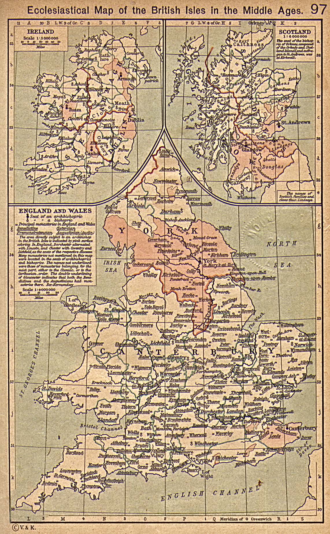
Hi Cattette, I was wondering if you would be able to make a map based on File:The British Isles about 1300.jpg? It would be really nice to see a high-quality modern rendering of that image. GPinkerton (talk) 09:19, 21 September 2021 (UTC)
- @GPinkerton: This looks interesting. I'll see if i can get around to it! Cattette (talk) 11:47, 21 September 2021 (UTC)
- Awesome, thanks so much! Ideally the bishoprics of Ireland and Scotland should be included as well; I've just seen that the bishoprics outside England aren't on that map, but they are on this one from the same atlas. (A map which itself could do with modernizing.) GPinkerton (talk) 11:58, 21 September 2021 (UTC)
- @GPinkerton: File:The British Isles around 1300.png I'm happy to announce that it is done! — Preceding unsigned comment added by Cattette (talk • contribs)
- AMAZING! That looks great! A few fixes: the "CAM" in "CAMBRIDGE" is missing in Cambridgeshire (not the city itself); Orkney should be the same colour as Shetland: neither archipelago was part of Scotland until a century later (maybe add "(NORWAY)" to the names of each?); the w:Soke of Peterborough has been left out/merged with the bishopric of Ely's w:Isle of Ely; the oddly-shaped and -scattered parts of the Welsh county of w:Flintshire has been merged into Cheshire; Berwick on Tweed is on the wrong side of the river (it should be on the north bank but marked as within Northumberland); and Tyndale and Redesdale in Northumberland have become merged. Also, can you please add in Edinburgh with same symbol as London and change the key to just "capital city" accordingly? You've done a great job for all the rest, so much better than the original! (BTW, if you don't sign a comment the ping is not sent!) GPinkerton (talk) 17:44, 27 September 2021 (UTC)
- @GPinkerton: "(BTW, if you don't sign a comment the ping is not sent!)" oops, sorry about that :P Thank you for your kind words and comments. I think I've ironed out most of the issues you pointed out. Cattette (talk) 19:54, 27 September 2021 (UTC)
- Great stuff! Yes that's rectified those issues. I found one or two more tweaks I'd like to ask for: Berwick on Tweed is now in the right place but should be shown on the same colour as County Durham not as Berwickshire (the city is a little English exclave north of the river, as today, the county is in Scotland); the word "Berwick" in Berwickshire has been displaced altogether by the "EAST MARCH" label, but Dumfriesshire and Roxburghshire have lost their "WEST MARCH" and "MIDDLE MARCH", even though there's more room for it. I would ask that you add them in, and if there isn't room for the six names of the three Scots border counties, remove all three "MARCH" labels and just add in "BERWICK" for Berwickshire instead of "EAST MARCH". Additionally, in the original map, the bishops' domains in Ely, Peterborough, and Durham are all the same colour, but this isn't the case in your map. Lastly, in the case of these areas, in Cheshire, and in the case of the Pale in Ireland, the colours of neighbouring areas are rather too similar (the Cheshire-Flintshire issue is in the original map; the colours are so alike). I would recommend a change in colours to bring out these areas' distinctiveness. A change in colour for Leinster would make the Pale show up much better. Otherwise it's nearing perfection. GPinkerton (talk) 20:25, 27 September 2021 (UTC)
- Another thing: the county of Bedfordshire has been absorbed by Buckinghamshire; please add in a boundary and possibly a label "BEDFORD". If there isn't enough space, the county names can all be abbreviated thus: "BEDS", "HUNTS", "HANTS", "CAMBS", etc. GPinkerton (talk) 21:42, 27 September 2021 (UTC)
- And another one (sorry!): I just realized the "about 1300" map also doesn't have the bishoprics in Wales marked (Bangor, St Asaph, St David's, Llandaff). They are, however, marked on the other map with bishoprics on. Please add them in, as they were there at the time. For St David's and St Asaph, it's normal for "Saint" to be abbreviated "St" rather than "St."; this is also true for St George's Channel, St Albans, Bury St Edmunds, St Andrews, etc. GPinkerton (talk) 21:57, 27 September 2021 (UTC)
- Another one: there's a typo in "Leinster". GPinkerton (talk) 21:33, 4 October 2021 (UTC)
- @GPinkerton: "(BTW, if you don't sign a comment the ping is not sent!)" oops, sorry about that :P Thank you for your kind words and comments. I think I've ironed out most of the issues you pointed out. Cattette (talk) 19:54, 27 September 2021 (UTC)
- AMAZING! That looks great! A few fixes: the "CAM" in "CAMBRIDGE" is missing in Cambridgeshire (not the city itself); Orkney should be the same colour as Shetland: neither archipelago was part of Scotland until a century later (maybe add "(NORWAY)" to the names of each?); the w:Soke of Peterborough has been left out/merged with the bishopric of Ely's w:Isle of Ely; the oddly-shaped and -scattered parts of the Welsh county of w:Flintshire has been merged into Cheshire; Berwick on Tweed is on the wrong side of the river (it should be on the north bank but marked as within Northumberland); and Tyndale and Redesdale in Northumberland have become merged. Also, can you please add in Edinburgh with same symbol as London and change the key to just "capital city" accordingly? You've done a great job for all the rest, so much better than the original! (BTW, if you don't sign a comment the ping is not sent!) GPinkerton (talk) 17:44, 27 September 2021 (UTC)
- @GPinkerton: File:The British Isles around 1300.png I'm happy to announce that it is done! — Preceding unsigned comment added by Cattette (talk • contribs)
- Awesome, thanks so much! Ideally the bishoprics of Ireland and Scotland should be included as well; I've just seen that the bishoprics outside England aren't on that map, but they are on this one from the same atlas. (A map which itself could do with modernizing.) GPinkerton (talk) 11:58, 21 September 2021 (UTC)
- Are you able to make these finishing touches? GPinkerton (talk) 18:52, 22 October 2021 (UTC)
Question on map[edit]
Hello Cattette,
Nice work on your maps. I was wondering - where did you get the "base" map for the 281 BC Hellenistic World map, i.e. just the oceans / lakes / rivers and structure? Is it a free resource open for others? I was thinking of attempting to make an update to File:Asia Minor 188 BCE.jpg for a few decades later, but having a nice terrain map on which to layer political control / cities / etc. would be handy. SnowFire (talk) 07:24, 11 October 2021 (UTC)
- @SnowFire: I described where I got the coast data from in the description of that map. Here's what I used, keep in mind that you will need to know how to operate GIS software to utilize these files. [1] Cattette (talk) 16:25, 11 October 2021 (UTC)
- Thanks for the info. I downloaded the shape files from the AWMC. Can I ask where you got your river data from? I used ba_merge from the AWMC set, and it works, but it's a little over-detailed - a few too many minor rivers as a distraction if the goal is showing political control. It seems the rivers your map used were a bit more constrained a set. Were they part of the AWMC too and I just missed them, or did you get them from elsewhere, or did you chop down the ba_merge set yourself? SnowFire (talk) 01:44, 14 October 2021 (UTC)
Cool[edit]
Hello Cattette, nice work.
New version of map File:Sumer Akkad.png?[edit]
Hi Cattette,
You're making some cool new maps! I was wondering whether you could upload an alternate version of File:Sumer Akkad.png? In the current version, you label some cities as "pre-flood cities". But that label is utterly meaningless; it comes from a specific version of a document called the "en:Sumerian King List", which is mostly a purely fictional(ized) list of kings. So, the distinction between "pre-flood" and other cities is just meaningless, and you won't find it in any proper handbook on the ancient Near East. Would it therefore be possible to upload a new version where the label pre-flood cities is removed? Thanks! Zoeperkoe (talk) 07:08, 15 November 2021 (UTC)
Morocco[edit]
Dear Cattette , I am sorry but your map of ancient Morocco is totally inaccurate ,unreliable and is based on old sources and old mistakes . Today historians place all the tribes you mentioned in northern Morocco only thanks to archeology for example the ZEGRENSES , the Mauri and the Baquates are located in the Rif northern Morocco.pease change your map. https://www.persee.fr/doc/mefr_0223-5102_1993_num_105_1_1800 ChtoukiMan (talk) 09:26, 24 June 2022 (UTC)
- Dear Cattette On these two links you can find the location of the peoples and settlements of ancient Morocco in accordance and correcting the errors of 19th century historians and the coordinate errors of Ptolemy. https://libra.unine.ch/Publications/Par-institut/COLLABORATEURSDELAFACULTEDESLETTRESETSCIENCESHUMAINES/46491 and https://www.persee.fr/doc/mefr_0223-5102_1993_num_105_1_1800
- Please and thank you ChtoukiMan (talk) 09:39, 24 June 2022 (UTC)
Map Request :)[edit]
Hi Cattette, I really love your maps, especially your map of Sicily! Do you still take requests? Looking for a map of a small rural region in Greece. Can you email me?
Thanks and all the best! Extratall (talk) 04:56, 16 January 2024 (UTC)
A barnstar for you![edit]

|
The Graphic Designer's Barnstar |
| Phenomenal Cartography Work! PandaWiki8 (talk) 19:20, 17 February 2024 (UTC) |