<nowiki>Brístol; Bristol; Bristol; Bristol; Бристоль; Bristol; Bristol; برسٹل; Bristol; Бристоль; 布里斯托尔; Bristol; Bristol; Бристоль; Bristol; Bristol; ब्रिस्टल; Bristol; Bristol; ब्रिस्टल; Бристол; Bristol; Bristol; Bristol; برستل; Bristol; 碧仙桃; Bristol; Bristol; Bristol; Bryste; Bristol; Bristol; بریستول; 布里斯托尔; Bristol; ბრისტოლი; ブリストル; Bristol; برستل; බ්රිස්ටල්; Bristolium; Bristol; 布里斯托尔; Bristol; Bristol; பிரிஸ்டல்; Bristol; Брыстал; Bristullu; Bristol; บริสตอล; Bristol; Bristol; Bristol; Bristol; بریستول; Бристъл; Bristol; 布里斯托; Bristol; 布里斯托; Bristol; Bristol; Bristolo; Bristón; ব্রিস্টল; Бристоль; 布里斯托尔; בריסטאל; Bristol; Bristol; Bristole; Bristol; Bristol; 布里斯托尔; Бристоль; Bristol; Bristol; ಬ್ರಿಸ್ಟಲ್; بریستۆڵ; Bristol; Bristol; Μπρίστολ; Bristol; Bristol; બ્રિસ્ટોલ; ब्रिस्टल; Bristol; برسٹل نگر; Bristol; بریستول; Bristol; Bristol; Բրիստոլ; Брысталь; Briostó; Bristol; Bristol; Bristol; ብርስተል; Bristol; Bristo; Bristol; Bristol; בריסטול; Бристол; Bristol; ਬਰਿਸਟਲ; ᱵᱨᱤᱥᱴᱚᱞ; Bristol; Bristol; ꯕ꯭ꯔꯤꯁ꯭ꯇꯣꯜ; Bristol; 브리스틀; Bristol; Бристол; Bristol; Bristol; Bristol; Bricgstōƿ; Бристоль; Bristol; Bristol; Bristol; 布里斯托; Bristol; Bristol; Bristol; Bristol; Bristolis; Bristol; Bristol; Bristol; Bristol; Bristol; Bristol; ബ്രിസ്റ്റൽ; Bristol; Bristol; బ్రిస్టల్; 布里斯托; Bristol; Bristol; Bristol; 布里斯托尔; Bristol; Ciudad y condado del sureste de Inglaterra; város Angliában; borg og sýsla í Englandi; город в Англии; Stadt, Unitary Authority und Grafschaft in England, Vereinigtes Königreich; Dinas yn Lloegr; city in England, United Kingdom; شهری در انگلستان; 英格兰城市; İngiltere'de bir şehir; イングランドの都市; Stadt, Unitary Authority und Grafschaft in England, Vereinigtes Königreich; stad i sydvästra England, Storbritannien; עיר בממלכה המאוחדת; ᱡᱩᱢᱤᱫᱽ ᱠᱤᱝᱰᱚᱢ ᱨᱮᱱᱟᱜ ᱮᱛᱚᱢ ᱯᱟᱪᱮ ᱤᱝᱞᱮᱱᱰ ᱨᱮ ᱥᱚᱦᱚᱨ; 영국 잉글랜드 서부의 에이번 강에 딸린 항구 도시이다.; гград и грофовија во Англија; zità te la Nghiltiera; ville et comté du Sud-Ouest de l'Angleterre au Royaume-Uni; grad u Engleskoj; cidade no Sudoeste da Inglaterra, Reino Unido; belt fil-Lbiċ tal-Ingilterra, ir-Renju Unit; Pilsēta Anglijā, Apvienotajā Karalistē; city in South West England, United Kingdom; město v Anglii; kondado; miasto w południowo-zachodniej Anglii; by i det sørvestlige England; tamdint deg unẓul-umalu n Legliz; горад у Паўднёва-Заходняй Англіі; місто в Англії; ibu kota Provinsi South West England, Inggris; Stadt, Unitary Authority und Grafschaft in England, Vereinigtes Königreich; cidade no sur de Inglaterra; مقاطعة في إنجلترا; plaats en gemeente in Engeland, Verenigd Koninkrijk; città e contea del Regno Unito in Inghilterra; Bristol; 碧仙桃; Bristol (Royaume-Uni); Bristol (Angleterre); 布里斯托爾; برسٹل; ᱵᱨᱤᱥᱴᱚᱞ, ᱤᱝᱞᱮᱱᱰ; Bristol, Inglaterra; Bristol, England; Bristol, Gloucestershire; Bristol, UK; بريستول; 布里斯托; பிரிஸ்டோல்</nowiki>
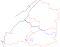
Bristol area with county boundaries, rivers, towns.
Bristol area with county boundaries, rivers, towns, roads and railways, no words.
Bristol area with most important/recognisable features.
Bristol area with county boundaries, rivers, towns, roads and railways.
Cropped version.
County boundary.
Ward boundaries.
Roads and rivers.
1866 map showing major streets
Bristol channel
This is a gallery page containing specially selected image and media files. They have been chosen as highlights of a particular topic, but do not represent the full range of files that are available on Commons. For a wider selection of files connected with Bristol, see Category:Bristol.


 The district of Redland
 Bristol Cathedral 1
 Bristol Cathedral 2
 Bristol Cathedral 3
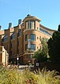 Bristol University School of Chemistry
 Bristol University Chemistry Department (old building)
 St Augustine's Parade at night
 Millenium Square at night
 Clifton Suspension Bridge from Brunel Way
 Bristol University, Wills Memorial Building
 The Triangle, Clifton
 The Industrial Museum
 St Mary Redcliffe Church
 St Pauls church
 Broadmead shopping centre in 2005
 Looking across Castle Park
 River Avon flowing past Castle Park
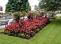 A flower bed in the gardens of Bristol Zoo.
 The Old Market roundabout
 Cabot Tower, distant view
 Cabot Tower, medium view
 Cabot Tower, close up
 Cabot Tower, extreme close up
 EasyJet Boeing 737 and Air Southwest DHC-8 Dash 8 at Bristol Airport
 Parkway railway station at Stoke Gifford, north of Bristol
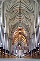 Interior of Bristol cathedral.
 The Llandoger Trow public house
 Temple Meads station
 Broadmead gateway feature; Christmas, at night
 The Tobacco Factory in Southville.
 Clifton Suspension Bridge
 Clifton Suspension Bridge
 1933
1933


 Bristol area with county boundaries, rivers.
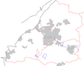 Bristol area with county boundaries, rivers, towns.
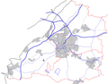 Bristol area with county boundaries, rivers, towns, roads and railways, no words.
 Bristol area with most important/recognisable features.
 Bristol area with county boundaries, rivers, towns, roads and railways.
 Cropped version.
 County boundary.
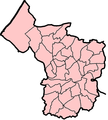 Ward boundaries.
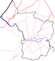 Roads and rivers.
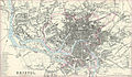 1866 map showing major streets
 Bristol channel


