Category:Þingeyjarsveit
Jump to navigation
Jump to search
English: Þingeyjarsveit is an icelandic municipality created by fusioning former municipalities Háls, Ljósavatn, Bárðdælahreppur, Reykdælahreppur und Aðaldalur.
Deutsch: Þingeyjarsveit ist eine isländische Gemeinde, die durch die Fusion der früheren Gemeinden Háls, Ljósavatn, Bárðdælahreppur, Reykdælahreppur und Aðaldalur entstand.
municipality of Iceland    | |||||
| Upload media | |||||
| Instance of | |||||
|---|---|---|---|---|---|
| Location | Northeastern Region, Iceland | ||||
| Capital | |||||
| Head of government |
| ||||
| Population |
| ||||
| Area |
| ||||
| official website | |||||
 | |||||
Subcategories
This category has the following 4 subcategories, out of 4 total.
G
- Grenjaðarstaður (6 F)
L
Media in category "Þingeyjarsveit"
The following 20 files are in this category, out of 20 total.
-
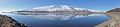
 2008-05-18 14 Ljósavatn.jpg 8,162 × 1,412; 3.3 MB
-
 2014-05-01 10-16-34 Iceland - Fosshólli Svalbarðseyri.jpg 13,625 × 2,617; 21.87 MB
-
 2014-05-01 10-17-43 Iceland - Fosshólli Svalbarðseyri.jpg 10,649 × 2,405; 13.89 MB
-
 2014-05-01 10-21-48 Iceland - Fosshólli Svalbarðseyri.jpg 12,844 × 2,467; 18.91 MB
-
 CoA of Þingeyjarsveit.png 216 × 288; 4 KB
-
 Controluce della cascata di Godafoss - panoramio.jpg 4,000 × 2,700; 5.14 MB
-
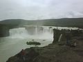 Goðafoss - panoramio.jpg 1,600 × 1,200; 290 KB
-
 Landscape at Goðafoss (14602914887).jpg 2,560 × 1,441; 433 KB
-
 Laugar.jpg 604 × 453; 35 KB
-
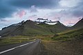
 Northern Ring Road of Iceland - 2013.08 - panoramio.jpg 4,250 × 3,188; 4.32 MB
-
 The Lone Pilgrimage (129439295).jpeg 2,048 × 1,365; 643 KB
-
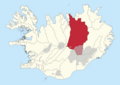
 Thingeyjarsveit map.png 507 × 373; 136 KB
-
 Twilight Of The Gods (237010075).jpeg 2,048 × 1,365; 554 KB
-
 Þingey.jpg 721 × 481; 86 KB
-
 Þingeyjarskóli í Þingeyjarsveit-2023.jpg 782 × 285; 53 KB
-
 Þingeyjarsveit 2002-2008 kort.png 3,507 × 2,480; 1.07 MB
-
 Þingeyjarsveit 2008-2022 kort.png 3,507 × 2,480; 1.05 MB
-
 Þingeyjarsveit frá 2022 kort.png 3,507 × 2,480; 1.03 MB
-
 Þingeyjarsveit Loc.svg 7,837 × 5,618; 295 KB
-
Þingeyjarsveit pronunciation.ogg 3.8 s; 206 KB


.jpg)


.jpeg)

.jpeg)


