Category:1560s maps of France
Jump to navigation
Jump to search
Subcategories
This category has the following 3 subcategories, out of 3 total.
Media in category "1560s maps of France"
The following 12 files are in this category, out of 12 total.
-

-
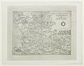
 La Carte de Berry - btv1b55004855d.jpg 4,061 × 3,947; 2.06 MB
-
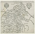
 Le Duché de Berry - par Jean Chaumeau - btv1b8493394k.jpg 5,664 × 5,056; 4.65 MB
-
 Lázaro Luis 1563.jpg 2,519 × 3,636; 7.12 MB
-

-

-
-
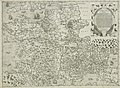
 Totius Galliae exactissima descriptio - Paulus Forlani Veronensis - btv1b55000084s.jpg 8,081 × 6,215; 6.24 MB
-
 Totius Galliae exactissima descriptio - Paulus Forlani Veronensis - btv1b550044960.jpg 8,146 × 6,214; 6.25 MB
-
 Totius Galliae exactissima descriptio - Paulus Forlani Veronensis - btv1b55004896h.jpg 7,714 × 5,630; 5.84 MB
-

-
 UBBasel Map 1563 Kartenslg AA 16b Gallia.tiff 10,475 × 9,015, 2 pages; 270.2 MB
.jpg)


_-_btv1b55004718q.jpg)


.jpg)