Category:1620s maps of Germany
Jump to navigation
Jump to search
Countries of Europe: Cyprus‡ · Denmark · Finland · France‡ · Georgia‡ · Germany · Greece · Republic of Ireland · Italy · Netherlands‡ · Poland · Portugal‡ · Russia‡ · Spain‡ · Turkey‡ · Ukraine
‡: partly located in Europe
‡: partly located in Europe
Federal states of Germany:
Subcategories
This category has the following 11 subcategories, out of 11 total.
- 1625 maps of Germany (empty)
- 1627 maps of Germany (empty)
- 1628 maps of Germany (4 F)
B
H
- 1620s maps of Hesse (2 F)
L
M
Media in category "1620s maps of Germany"
The following 4 files are in this category, out of 4 total.
-

-
-
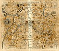
 A Newe mape of Germany - newly augmented by John Speed - btv1b10111216f (1 of 2).jpg 6,731 × 5,148; 6.53 MB
-

_(BM_1870,1112.208).jpg)
_(BM_1874,0613.2525).jpg)
.jpg)
_(BM_1870,1112.207).jpg)