Category:1650s maps of France
Jump to navigation
Jump to search
Countries of Europe: Armenia‡ · Belgium · Bosnia and Herzegovina · Bulgaria · Croatia · Cyprus‡ · Denmark · France‡ · Germany · Greece · Hungary · Republic of Ireland · Italy · Latvia · Lithuania · Netherlands‡ · Norway · Poland · Portugal‡ · Romania · Russia‡ · Slovenia · Spain‡ · Sweden · Switzerland · Turkey‡ · Ukraine
‡: partly located in Europe
‡: partly located in Europe
Former administrative regions of Metropolitan France (until end of 2015):
Alsace
Alsace
Subcategories
This category has the following 12 subcategories, out of 12 total.
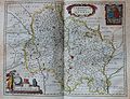
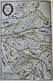
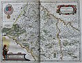
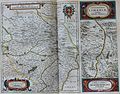
Media in category "1650s maps of France"
The following 63 files are in this category, out of 63 total.
-
 "Dioecese de Rheims, et le pais de Rethel - par Iean Iubrien...." (21633362704).jpg 3,710 × 2,982; 2.26 MB
-
 "Perchensis Comitatus = La perche comté." (21633061954).jpg 1,698 × 2,846; 1.14 MB
-
 "Pictaviae ducatus descriptio, vulgo Le Pais de Poictou." (21633035894).jpg 4,026 × 2,980; 2.58 MB
-
 1650-carte du gouvernement général d'Orléans.JPG 391 × 300; 34 KB
-
 A-3-37-56-France.jpg 3,000 × 2,239; 892 KB
-
 Gouvernement general de la Picardie (...)Sanson Nicolas btv1b59717469 1.jpg 1,370 × 1,053; 566 KB
-
 Gouvernement général de Languedoc divisé en ses vingt deux diocèses. - btv1b10678251h.jpg 6,640 × 5,031; 7.72 MB
-
 Gouvernement général du Languedoc (Nicolas Sanson, 1651).jpg 6,656 × 5,120; 24.46 MB
-
 Dioecese de lEvesché dOrleans (5121154146).jpg 2,000 × 1,492; 3.31 MB
-
 1653-carte du diocèse de l'évêché d'Orléans.JPG 398 × 300; 36 KB
-

-

-

-

-

-
 "Britannia Ducatus = Duché de Bretaigne." (21633186294).jpg 3,939 × 2,927; 2.62 MB
-
 "Carte du Bourdelois du pais de Medoc et de la provosté de Born." (21634612573).jpg 1,756 × 2,862; 1.04 MB
-
 "Normandia ducatus" (22069102069).jpg 3,926 × 2,925; 2.63 MB
-

-
 "Archiepiscopatus Cameracensis = Archevesché de Cambray." (22244014692).jpg 3,815 × 2,980; 2.22 MB
-
 "Artesia Comitatus = Artois" (22267367091).jpg 3,837 × 3,019; 2.93 MB
-
 "Auvergne" (22229091776).jpg 3,639 × 3,043; 2.49 MB
-
 "Belsia, vulgo La Beausse" (22243063572).jpg 3,779 × 2,928; 2.53 MB
-
 "Bituricum Ducatus = Duche de Berri." (22255722655).jpg 3,918 × 3,000; 2.41 MB
-
 "Borbonium ducatus = Bourbonnois" (22242381592).jpg 4,002 × 3,072; 2.63 MB
-
 "Bressia, vulgo Bresse" (21634105453).jpg 4,078 × 3,120; 2.65 MB
-
 "Burgundia comitatus vulgo la Franche comté." (21632334314).jpg 3,774 × 2,976; 2.73 MB
-
 "Cadurcium Vernacule Querci" (22067626240).jpg 4,050 × 3,108; 2.41 MB
-
 "Champagne, latine Campania, comitatus" (22256134525).jpg 3,915 × 3,033; 3 MB
-
 "Comitatus Blesensis" (21634773093).jpg 1,830 × 2,837; 1.21 MB
-

-
 "Dioecesis Ebroicensis vulgo L´Eveschè d´Evreux." (22255976735).jpg 3,733 × 3,084; 2.3 MB
-

-

-
 "Episcopatus Albiensis = Evesche D`Alby" (22265986951).jpg 3,690 × 3,000; 2.28 MB
-
 "Gallia, vulgo La France" (21633571964).jpg 3,856 × 3,008; 2.83 MB
-
 "Gastinois et Hurepois" (22068162500).jpg 3,647 × 2,803; 2.45 MB
-
 "Gouvernement de La Guienne & Gascogne." (22255624975).jpg 3,906 × 3,049; 2.89 MB
-
 "Gouvernement General du Lyonnois" (21634199413).jpg 4,176 × 3,072; 2.68 MB
-
 "Gouvernement general du Pays Orleanois." (22243048762).jpg 3,791 × 3,033; 2.97 MB
-

-
 "Languedoc" (22229404636).jpg 3,894 × 3,126; 3.07 MB
-
 "Le Duche D'Aiguillon - par... Pierre du Val..." (21634542633).jpg 4,062 × 3,108; 2.02 MB
-
 "Le gouvernement de L'Isle de France - par Damien de Templeux..." (22230152446).jpg 3,589 × 2,857; 2.46 MB
-
 "Le Pays & diocese de Mans vulgairement Le Maine ubi olim Cenomanni." (22229861726).jpg 3,921 × 3,092; 2.94 MB
-
 "Le Pays de Caux." (21634885783).jpg 4,101 × 2,910; 2.73 MB
-
-

-
 "Les souverainetez de Sedan et de Raucourt et la prevosté de Doncheri." (22228898096).jpg 3,694 × 2,934; 2.19 MB
-
 "Lionnois, Forest, Beaviolois et Masconois" (21634336003).jpg 4,158 × 3,084; 2.68 MB
-
 "L´Evesché D´Aire - tracé par... Pierre de Val..." (22067797878).jpg 3,695 × 2,982; 2.06 MB
-
 "Nivernium ducatus, Gallicè Duche de Nevers." (22234378416).jpg 3,897 × 3,013; 2.97 MB
-
 "Principatus Benearnia = La principaute de Bearn." (22068716599).jpg 2,098 × 3,045; 1.35 MB
-
 "Provincia = Provence - auctore Petro Joanne Bompario." (22068567609).jpg 4,175 × 3,002; 2.97 MB
-

-
 "Senonois & La partie meridionale de la Champagne." (22230005356).jpg 4,215 × 3,102; 3.17 MB
-
 "Territorium Bergense - Iacobus de la Fontaine" (21635941713).jpg 3,777 × 2,972; 2.55 MB
-
 Le Duche D'Aiguillon.jpg 1,280 × 979; 1.01 MB
-
 Carte du Dauphiné - btv1b530532836.jpg 11,237 × 10,367; 20.16 MB
-
 Duché et gouvernement de Bretagne - par N. Sanson d'Abbeville - btv1b8592534x.jpg 8,546 × 6,368; 9.77 MB
-
 Plan Rade Lorient XVIIe siècle.jpg 1,355 × 899; 611 KB
-

-
 The Game of France WDL3026.png 1,341 × 1,024; 2.5 MB
.jpg)
.jpg)
.jpg)


Sanson_Nicolas_btv1b59717469_1.jpg)

.jpg)
.jpg)


_-_btv1b52511195b_(21_of_85).jpg)
.jpg)
.jpg)
.jpg)

.jpg)
.jpg)
.jpg)
.jpg)
.jpg)
.jpg)
.jpg)
.jpg)
.jpg)
.jpg)
.jpg)
.jpg)
.jpg)
.jpg)
.jpg)
.jpg)
.jpg)
.jpg)
.jpg)
.jpg)
.jpg)
.jpg)
.jpg)
.jpg)
.jpg)
.jpg)
.jpg)
.jpg)
.jpg)
.jpg)
.jpg)
.jpg)
.jpg)
.jpg)
.jpg)
.jpg)
.jpg)
.jpg)


.jpg)
