Category:1810s maps of India
Jump to navigation
Jump to search
Subcategories
This category has the following 5 subcategories, out of 5 total.
- 1812 maps of India (1 F)
- 1814 maps of India (8 F)
- 1815 maps of India (4 F)
- 1816 maps of India (3 F)
- 1818 maps of India (3 F)
Media in category "1810s maps of India"
The following 7 files are in this category, out of 7 total.
-
 1801 - 20 - 42 1811 Survey of Part of the Sunderbunds by Morrieson.jpg 9,095 × 6,584; 2.87 MB
-
 1801 - 20 - 26(C) 1802 Kurungotte District.jpg 6,213 × 7,793; 16.29 MB
-
 Outlines of the Countries Between Delhi and Constantinople By A. Arrowsmith 1814. Additions to 1816.jpg 51,566 × 29,000; 367.93 MB
-

-
 Ground plan of the Jami Masjid, Delhi.jpg 634 × 712; 184 KB
-
 Historical Records of the Survey of India Vol.-3.pdf 1,816 × 2,641, 590 pages; 43.84 MB
-
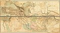
 Northeast-India-in-1814-Thomson-map.jpg 971 × 1,319; 881 KB

_1802_Kurungotte_District.jpg)

.jpg)

