Category:1840s maps of India
Jump to navigation
Jump to search
Countries of Asia: Afghanistan · Armenia‡ · Azerbaijan‡ · People's Republic of China · Cyprus‡ · Egypt‡ · Georgia‡ · India · Indonesia‡ · Iran · Iraq · Japan · Lebanon · Pakistan · Philippines · Russia‡ · Syria · Turkey‡ · Turkmenistan · Uzbekistan
Limited recognition: Abkhazia‡ · Taiwan · State of Palestine
‡: partly located in Asia
Limited recognition: Abkhazia‡ · Taiwan · State of Palestine
‡: partly located in Asia
Subcategories
This category has the following 6 subcategories, out of 6 total.
- 1842 maps of India (2 F)
- 1844 maps of India (3 F)
- 1845 maps of India (2 F)
- 1846 maps of India (2 F)
- 1847 maps of India (1 F)
- 1848 maps of India (1 F)
Media in category "1840s maps of India"
The following 15 files are in this category, out of 15 total.
-

-
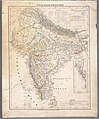 Vorderindien.jpg 4,519 × 5,452; 7.48 MB
-
 Kashmir Map.jpg 7,723 × 11,478; 30.89 MB
-

-

-
 Vorder Indien Platt 1848.pdf 2,395 × 2,864; 815 KB
-

-

-
 Barclay's Dictionary India.jpg 4,639 × 6,193; 18.13 MB
-
 Battle of Alliwal 18460128.jpg 2,724 × 2,382; 2.71 MB
-
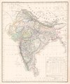
 India in 1848 Joppen.jpg 2,026 × 2,913; 1.82 MB
-

-
 Meyer‘s Zeitungsatlas 054 – Ostindien.jpg 7,358 × 6,265; 15.27 MB
-
 Sujat Khan Mosque, Tomb and Sarai Complex plan (11229568313).jpg 1,546 × 845; 232 KB
-
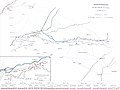 Sutlej-Campaign 1845-6 Map-German.jpg 3,106 × 2,326; 1.93 MB
_and_India_(Hindoostan)_in_1840_from_10_of_%27(A_universal_Gazetteer;_or_geographical_dictionary_of_the_World._Founded_on_the_works_of_Brookes_and_Walker,_etc.)%27_(11017880235)_(cropped).jpg)


.jpg)
.jpg)
.jpg)
.jpg)


_and_Lhasa_(HLassa)_in_1840_from_Oestliche_Halbkugel_(cropped).jpg)

.jpg)
