Category:1848 maps of South America
Jump to navigation
Jump to search
Temperate regions: North America · South America · Africa · Europe · Asia · Oceania – Polar regions: – Other regions:
| ← 1840 1841 1842 1843 1844 1846 1847 1848 1849 → |
Media in category "1848 maps of South America"
The following 7 files are in this category, out of 7 total.
-
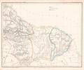 Karte vom englischen holländischen und französischen Guyana Platt 1848.pdf 2,904 × 2,425; 484 KB
-
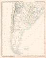 Karte von La Plata Chili Paraguay Uruguay und Patagonien Platt 1848.pdf 2,397 × 2,993; 632 KB
-
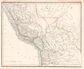 Karte von Peru und Bolivia Platt 1848.pdf 2,920 × 2,410; 588 KB
-
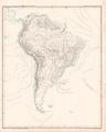 Oro- und Hydrographische Karte von Südamerika Platt 1848.pdf 2,397 × 2,993; 615 KB
-
 Amérique du Sud - par A.-H. Dufour - btv1b8469146v.jpg 6,140 × 7,512; 6.39 MB
-
 Amérique du Sud - par A.-H. Dufour - btv1b8469625d.jpg 5,928 × 7,312; 5.89 MB
-


