Category:1886 maps of Wisconsin
Jump to navigation
Jump to search
States of the United States: California · Connecticut · Georgia · Illinois · Iowa · Kansas · Kentucky · Louisiana · Maine · Maryland · Massachusetts · Michigan · Mississippi · Missouri · Montana · New Hampshire · New Jersey · New Mexico · New York · Ohio · Pennsylvania · Rhode Island · South Carolina · South Dakota · Tennessee · Texas · Utah · Vermont · Virginia · West Virginia · Wisconsin · Wyoming
Puerto Rico
Puerto Rico
| 1880 1883 1884 1885 1886 1887 1888 1889 → |
Subcategories
This category has only the following subcategory.
Media in category "1886 maps of Wisconsin"
The following 19 files are in this category, out of 19 total.
-

-
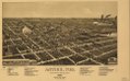 A bird's eye view of the city of Antigo, Wis. county seat of Langlade County 1886. LOC 75696698.tif 7,760 × 4,848; 107.63 MB
-
 A bird's eye view of the city of Ashland, Wis., county seat of Ashland County 1886. LOC 75696701.jpg 10,736 × 5,968; 14.85 MB
-
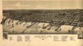 A bird's eye view of the city of Ashland, Wis., county seat of Ashland County 1886. LOC 75696701.tif 10,736 × 5,968; 183.31 MB
-
 Bird's eye view of Bayfield, Wis., county seat of Bayfield County 1886. LOC 75696703.jpg 6,592 × 5,208; 6.12 MB
-
 Bird's eye view of Bayfield, Wis., county seat of Bayfield County 1886. LOC 75696703.tif 6,592 × 5,208; 98.22 MB
-
 Birds eye view of Washburn, Wis. Bayfield County 1886. LOC 75696724.jpg 7,056 × 5,136; 7.43 MB
-
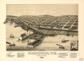 Birds eye view of Washburn, Wis. Bayfield County 1886. LOC 75696724.tif 7,056 × 5,136; 103.68 MB
-
 Chippewa-Falls, Wis., county-seat of Chippewa-County 1886. LOC 75696705.jpg 9,088 × 6,848; 12.95 MB
-
 Chippewa-Falls, Wis., county-seat of Chippewa-County 1886. LOC 75696705.tif 9,088 × 6,848; 178.05 MB
-
 Hurley, Wis., Ashland County 1886. LOC 75696708.jpg 6,448 × 4,000; 5.13 MB
-
 Hurley, Wis., Ashland County 1886. LOC 75696708.tif 6,448 × 4,000; 73.79 MB
-
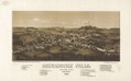
 Menomonee Falls, Waukesha County, Wisconsin. 1886. LOC 75696714.jpg 6,824 × 4,248; 4.84 MB
-
 Menomonee Falls, Waukesha County, Wisconsin. 1886. LOC 75696714.tif 6,824 × 4,248; 82.94 MB
-

-

-
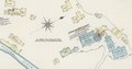
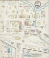
 Sanborn Fire Insurance Map from Mazomanie, Dane County, Wisconsin. LOC sanborn09612 001.jpg 6,406 × 7,547; 3.91 MB
-
 Sanborn Fire Insurance Map from Mazomanie, Dane County, Wisconsin. LOC sanborn09612 001.tif 6,406 × 7,547; 138.32 MB
-