Category:1900 United States gubernatorial election maps
Jump to navigation
Jump to search
Media in category "1900 United States gubernatorial election maps"
The following 11 files are in this category, out of 11 total.
-
 1900 Alabama gubernatorial election results map by county.svg 800 × 1,254; 861 KB
-
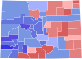 1900 Colorado gubernatorial election results map by county.svg 275 × 218; 21 KB
-
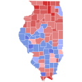 1900 Illinois gubernatorial election results map by county.svg 810 × 810; 30 KB
-

-
 1900 Massachusetts gubernatorial election results map by county.svg 201 × 118; 13 KB
-
 1900 Michigan gubernatorial election results map by county.svg 287 × 313; 43 KB
-
 1900 Minnesota gubernatorial election results map by county.svg 289 × 324; 1.38 MB
-
 1900 New York gubernatorial election results map by county.svg 744 × 577; 295 KB
-
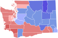 1900 Washington gubernatorial election results map by county.svg 166 × 124; 35 KB
-
 Map of Results of Colorado Gubernatorial Election 1900, by county.png 1,280 × 1,010; 57 KB
-
 USgubernatorial1900.png 2,000 × 1,237; 104 KB


