Category:1906 United States gubernatorial election maps
Jump to navigation
Jump to search
Media in category "1906 United States gubernatorial election maps"
The following 13 files are in this category, out of 13 total.
-
 1906 Alabama gubernatorial election results map by county.svg 744 × 744; 329 KB
-
 1906 CA Gov.svg 512 × 602; 853 KB
-
 1906 California gubernatorial election results map by county.svg 234 × 262; 68 KB
-
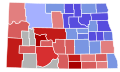
 1906 Colorado gubernatorial election results map by county.svg 800 × 579; 843 KB
-
 1906 Massachusetts gubernatorial election results map by county.svg 810 × 502; 27 KB
-
 1906 Michigan gubernatorial election results map by county.svg 287 × 313; 43 KB
-
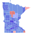 1906 Minnesota gubernatorial election results map by county.svg 289 × 324; 1.38 MB
-
 1906 New York gubernatorial election results map by county.svg 744 × 577; 295 KB
-
 1906 North Dakota gubernatorial election results map by county.svg 512 × 306; 22 KB
-
 1906 Pennsylvania gubernatorial election results map by county.svg 810 × 471; 50 KB
-
 1906 Wisconsin gubernatorial election results map by county.svg 245 × 262; 27 KB
-
 Map of Results of Colorado Gubernatorial Election 1906, by county.png 1,280 × 1,010; 57 KB
-
 USgubernatorial1906.png 2,000 × 1,237; 49 KB


