Category:1900 maps of North Dakota
Jump to navigation
Jump to search
States of the United States: California · Connecticut · Georgia · Idaho · Illinois · Iowa · Kansas · Michigan · Minnesota · Missouri · Nebraska · New Jersey · New York · North Carolina · North Dakota · Ohio · Oklahoma · Pennsylvania · South Carolina · South Dakota · Tennessee · Texas · Utah · Virginia · Washington · West Virginia · Wisconsin · Wyoming – Washington, D.C.
| 1900 1901 1904 1905 1906 1907 1908 1909 → |
Media in category "1900 maps of North Dakota"
This category contains only the following file.
-
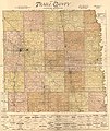 Map of Traill County, North Dakota LOC 2011590017.jpg 12,963 × 15,425; 33.28 MB
