Category:1900 maps of South Carolina
Jump to navigation
Jump to search
States of the United States: California · Connecticut · Georgia · Idaho · Illinois · Iowa · Kansas · Massachusetts · Michigan · Minnesota · Missouri · Nebraska · New Jersey · New York · North Carolina · North Dakota · Ohio · Oklahoma · Pennsylvania · South Carolina · South Dakota · Tennessee · Texas · Utah · Virginia · Washington · West Virginia · Wisconsin · Wyoming – Washington, D.C.
| ← 1900 |
Media in category "1900 maps of South Carolina"
The following 5 files are in this category, out of 5 total.
-
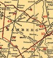 Bamberg County on South Carolina railroads 1900 (cropped).tif 750 × 820; 1.76 MB
-

-

-
 South Carolina railroads. LOC 98688558.jpg 8,416 × 6,256; 9.68 MB
-
 South Carolina railroads. LOC 98688558.tif 8,416 × 6,256; 150.63 MB

