Category:1911 maps of India
Jump to navigation
Jump to search
| ← 1910 1911 1912 1913 1914 1915 1916 1917 1918 1919 → |
English: 1911 maps made in India or from India or showing history of India
Media in category "1911 maps of India"
The following 14 files are in this category, out of 14 total.
-

-
 A Handbook for Travellers in India, Burma, and Ceylon.djvu 1,861 × 2,802, 792 pages; 22.43 MB
-
 Bangalore Murray.jpg 1,329 × 1,095; 1.26 MB
-
 Bashar 1911.png 734 × 604; 198 KB
-
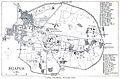 Bijapur Murray.jpg 2,464 × 1,616; 2.3 MB
-
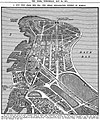 BombayReclamation 1911.jpg 1,622 × 1,948; 2.5 MB
-
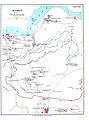
 Chamba Kangra Bilaspur Mandi Kulu 1911.jpeg 744 × 873; 130 KB
-
 Hampi Murray.jpg 1,446 × 1,943; 1.42 MB
-
 Kalsia-Punjab-Districts 1911.png 569 × 448; 162 KB
-
 Ludhiana District 1911.png 534 × 493; 111 KB
-
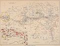
 Population density map of British India according to 1911 Census.jpg 2,976 × 2,544; 7.09 MB
-
 Punjab-Districts 1911.png 569 × 448; 113 KB
-
 Simla and Jutogh 1911 map.jpg 1,740 × 1,346; 350 KB
-
 Yangi-hindutash-aurel-stein-map-1911.jpg 1,965 × 2,824; 1.92 MB


