Category:1914 United States gubernatorial election maps
Jump to navigation
Jump to search
Media in category "1914 United States gubernatorial election maps"
The following 19 files are in this category, out of 19 total.
-
 1914 Arkansas gubernatorial election results map by county.svg 744 × 655; 385 KB
-
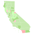 1914 California gubernatorial election results map by county.svg 744 × 744; 601 KB
-
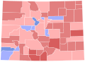 1914 Colorado gubernatorial election results map by county.svg 810 × 589; 36 KB
-
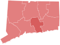 1914 Connecticut gubernatorial election results map by county.svg 810 × 595; 22 KB
-
 1914 Kansas gubernatorial election results map by county.svg 744 × 400; 215 KB
-
 1914 Massachusetts gubernatorial election results map by county.svg 810 × 502; 22 KB
-
 1914 Michigan gubernatorial election results map by county.svg 287 × 313; 43 KB
-
 1914 Minnesota gubernatorial election results map by county.svg 289 × 324; 1.16 MB
-
 1914 Nevada gubernatorial election results map by county.svg 810 × 810; 15 KB
-
 1914 New York gubernatorial election results map by county.svg 810 × 621; 67 KB
-
 1914 North Dakota gubernatorial election results map by county.svg 273 × 163; 30 KB
-
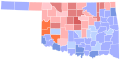 1914 Oklahoma gubernatorial election results map by county.svg 320 × 168; 47 KB
-
 1914 Pennsylvania gubernatorial election results map by county.svg 810 × 471; 50 KB
-

-
 1914 Wisconsin gubernatorial election results map by county.svg 245 × 262; 1.85 MB
-
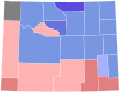 1914 Wyoming gubernatorial election results map by county.svg 221 × 184; 10 KB
-
 1914ALGOV.svg 744 × 744; 329 KB
-
 Connecticut Governor Election Results by County, 1914.svg 166 × 136; 9 KB
-
 USgubernatorial1914.png 2,000 × 1,237; 48 KB


