Category:1918 United States gubernatorial election maps
Jump to navigation
Jump to search
Media in category "1918 United States gubernatorial election maps"
The following 27 files are in this category, out of 27 total.
-
 1918 Alabama gubernatorial election results map by county.svg 744 × 744; 329 KB
-
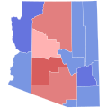 1918 Arizona gubernatorial election results map by county.svg 810 × 810; 18 KB
-
 1918 Arkansas gubernatorial election results map by county.svg 810 × 709; 46 KB
-
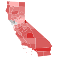 1918 California gubernatorial election results map by county.svg 744 × 744; 601 KB
-
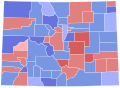 1918 Colorado gubernatorial election results map by county.svg 810 × 589; 36 KB
-
 1918 Connecticut gubernatorial election results map by county.svg 810 × 595; 22 KB
-

-
 1918 Idaho gubernatorial election results map by county.svg 800 × 1,243; 1.07 MB
-
 1918 Massachusetts gubernatorial election results map by county.svg 810 × 502; 22 KB
-
 1918 Michigan gubernatorial election results map by county.svg 810 × 810; 43 KB
-
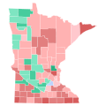 1918 Minnesota gubernatorial election results map by county.svg 794 × 794; 266 KB
-
 1918 Nevada gubernatorial election results map by county.svg 810 × 810; 15 KB
-
 1918 New Hampshire gubernatorial election results map by county.svg 810 × 810; 14 KB
-
 1918 New Mexico gubernatorial election results map by county.svg 810 × 810; 189 KB
-
 1918 New York gubernatorial election results map by county.svg 744 × 577; 297 KB
-
 1918 North Dakota gubernatorial election results map by county.svg 810 × 488; 29 KB
-
 1918 Ohio gubernatorial election results map by county.svg 810 × 810; 40 KB
-
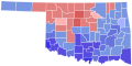 1918 Oklahoma gubernatorial election results map by county.svg 810 × 404; 37 KB
-
 1918 Oregon gubernatorial election results map by county.svg 810 × 608; 33 KB
-
 1918 Pennsylvania gubernatorial election results map by county.svg 810 × 471; 50 KB
-
 1918 South Dakota gubernatorial election results map by county.svg 800 × 497; 30 KB
-
 1918 Tennessee gubernatorial election results map by county.svg 810 × 206; 69 KB
-
 1918 Vermont gubernatorial election results map by county.svg 810 × 810; 17 KB
-
 1918 Wisconsin gubernatorial election results map by county.svg 794 × 794; 217 KB
-
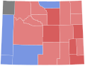 1918 Wyoming gubernatorial election results map by county.svg 810 × 624; 15 KB
-
 New York Governor Election Results by County, 1918.png 1,700 × 1,100; 32 KB
-
 Wisconsin gubernatorial election, 1918 County Results.png 325 × 273; 4 KB


