Category:1950s maps of India
Jump to navigation
Jump to search
Countries of Asia: Afghanistan · People's Republic of China · Egypt‡ · Georgia‡ · India · Indonesia‡ · Iran · Iraq · Israel · Japan · Jordan · Laos · Lebanon · Malaysia · Mongolia · Myanmar · Nepal · Pakistan · Philippines · Russia‡ · Syria · Thailand · Turkey‡ · Vietnam
Limited recognition: Abkhazia‡ · Taiwan · State of Palestine
‡: partly located in Asia
Limited recognition: Abkhazia‡ · Taiwan · State of Palestine
‡: partly located in Asia
Subcategories
This category has the following 10 subcategories, out of 10 total.
- 1950 maps of India (4 F)
- 1952 maps of India (4 F)
- 1953 maps of India (2 F)
- 1954 maps of India (5 F)
- 1956 maps of India (15 F)
- 1957 maps of India (9 F)
- 1958 maps of India (3 F)
- 1959 maps of India (10 F)
Media in category "1950s maps of India"
The following 5 files are in this category, out of 5 total.
-
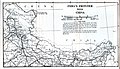 1959 India's Frontier with China by Indian Ministry of External Affairs.jpg 4,392 × 2,514; 1.04 MB
-
 1959 Political Map of India showning boundary with China.jpg 7,056 × 4,926; 3.17 MB
-
 India 1955-60.jpg 1,378 × 924; 422 KB
-
 Jammu and Kashmir in 1959 Political Map of India.jpg 2,137 × 1,515; 937 KB
-
 Wahltermine in Indien 1951–1952.svg 1,020 × 1,154; 162 KB


